City of Mackay
| City of Mackay Queensland | |||||||||||||
|---|---|---|---|---|---|---|---|---|---|---|---|---|---|
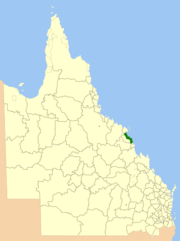 Location within Queensland | |||||||||||||
| Population | 84,890 (2006)[1] | ||||||||||||
| • Density | 29.2977/km2 (75.881/sq mi) | ||||||||||||
| Established | 1869 | ||||||||||||
| Area | 2,897.5 km2 (1,118.7 sq mi) | ||||||||||||
| Council seat | Mackay | ||||||||||||
| Region | Central Queensland | ||||||||||||
 | |||||||||||||
| Website | City of Mackay | ||||||||||||
| |||||||||||||
The City of Mackay was a local government area located in the Central Queensland region of Queensland, Australia, encompassing the regional city of Mackay and the surrounding region. The City was created as a municipal borough in 1869, and prior to amalgamation with the Shire of Pioneer in 1994, the City was limited to the central suburbs on the south shore of the Pioneer River. From 1994 until 2008, the City covered an area of 2,897.5 square kilometres (1,118.7 sq mi). In 2008, it amalgamated with the Shires of Mirani and Sarina to become the Mackay Regional Council.
History
The Borough of Mackay was proclaimed on 22 September 1869 under the Municipal Institutions Act 1864.[2] The Pioneer Division was established on 11 November 1879 as one of 74 founding divisions under the Divisional Boards Act 1879.
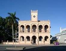
Initially the council meetings were held in the Court House in River Street, the Post and Telegraph office in Wood Street, and in a building on Sydney Street owned by Mr R. Fleming. The first town hall was a timber structure constructed in 1872 on land that the council purchased at 63 Sydney Street.[3]
With the passage of the Local Authorities Act 1902, Pioneer Division became the Shire of Pioneer and Mackay became Town of Mackay on 31 March 1903. Mackay received City status on 17 August 1918.
During the boom in sugar prices, the borough council decided in 1884 that a larger town hall was needed. However, it was not until 1909 that they decided to proceed with a brick building on the site of the existing town hall in Sydney Street. The council held a design competition, which was won by a local architect and engineer Arthur Rigby. The first town hall was moved to the rear of the block to be behind the new building. The first official Council meeting was held in the new town hall on 19 October 1912 with the official opening the next day.[3]
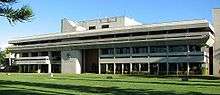
After the council moved into their new Civic Administration Centre in 1974, they proposed to demolish the town hall and sell off the land to defray the costs of the new civic centre. However, following public protest, they renovated the building to make it available for community purposes.[3]
On 21 November 1991, the Electoral and Administrative Review Commission, created two years earlier, produced its second report, and recommended that local government boundaries in the Mackay area be rationalised. The Local Government (Mackay and Pioneer) Regulation 1993 was gazetted on 17 December 1993, and on 30 March 1994, the two amalgamated into a larger City of Mackay, which first met on 8 April 1994.
On 15 March 2008, under the Local Government (Reform Implementation) Act 2007 passed by the Parliament of Queensland on 10 August 2007, the City of Mackay merged with the Shires of Mirani and Sarina to form the Mackay Regional Council.
Towns and localities
Prior to 1994, Mackay consisted of the suburbs of North Mackay, West Mackay, South Mackay and East Mackay.
All other suburbs of Mackay belonged into the defunct Shire of Pioneer.
After the amalgamation, the City of Mackay included the following settlements:
|
Suburbs:
|
Towns:
National Parks: |
Other localities: |
Mayors
- 1918: William Crawford Weir [4]
- 1924–1927: Lewis Windermere Nott[5]
- 1994–1999: Gordon White (prior to the amalgamation, White had been chairman of the Pioneer Shire Council (1983–1994)[6]
Transport
- Mackay Airport
- North Coast railway line, Mackay Station
- Bruce Highway
Sister cities
 Matsuura, Japan (Nagasaki Prefecture)
Population
| Year | Population (Mackay) |
Population (Pioneer) |
Population (Total) |
|---|---|---|---|
| 1933 | 10,665 | 9,926 | 20591 |
| 1947 | 13,486 | 11,606 | 25092 |
| 1954 | 14,762 | 14,316 | 29,078 |
| 1961 | 16,809 | 15,741 | 32,550 |
| 1966 | 18,640 | 19,900 | 38,540 |
| 1971 | 19,148 | 22,561 | 41,709 |
| 1976 | 20,224 | 26,938 | 47,162 |
| 1981 | 20,664 | 33,732 | 54,396 |
| 1986 | 22,199 | 36,084 | 58,283 |
| 1991 | 23,052 | 40,614 | 63,666 |
| 1996 | 71,894 | ||
| 2001 | 75,020 | ||
| 2006 | 20,803 | 85,399 | |
| 2015 | 120,000 | ||
References
- ↑ Australian Bureau of Statistics (25 October 2007). "Mackay (C) (Local Government Area)". 2006 Census QuickStats. Retrieved 16 April 2015.
- ↑ "Agency ID10385, Mackay Municipal Council". Queensland State Archives. Retrieved 22 January 2014.
- 1 2 3 "Mackay Town Hall (former) (entry 601107)". Queensland Heritage Register. Queensland Heritage Council. Retrieved 22 January 2014.
- ↑ Australian History Publishing Co (1936), Queensland and Queenslanders : incorporating 'Prominent Queenslanders', Australian History Publishing Co, p. 299, retrieved 1 October 2015 — available online
- ↑ Pugh, Theophilus Parsons (1927). Pugh's Almanac for 1927. Retrieved 13 June 2014.
- ↑ "Pioneer Shire Council Building (former) (entry 602603)". Queensland Heritage Register. Queensland Heritage Council. Retrieved 1 August 2014.
Coordinates: 21°08′28.31″S 149°11′08.26″E / 21.1411972°S 149.1856278°E