Shire of Baw Baw
| Shire of Baw Baw Victoria | |||||||||||||
|---|---|---|---|---|---|---|---|---|---|---|---|---|---|
 Location in Victoria | |||||||||||||
| Population | 46,638 (2015 est)[1] | ||||||||||||
| • Density | 11.5698/km2 (29.966/sq mi) | ||||||||||||
| Established | 1994 | ||||||||||||
| Gazetted | 2 December 1994[2] | ||||||||||||
| Area | 4,031 km2 (1,556.4 sq mi) | ||||||||||||
| Mayor | Cr Murray Cook | ||||||||||||
| Council seat | Warragul | ||||||||||||
| Region | Eastern Victoria | ||||||||||||
| State electorate(s) | Narracan | ||||||||||||
| Federal Division(s) | McMillan | ||||||||||||
|
| |||||||||||||
| Website | Shire of Baw Baw | ||||||||||||
| |||||||||||||
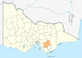
The Shire of Baw Baw is a local government area in Victoria, Australia, in the eastern part of the state. It covers an area of 4,031 square kilometres (1,556 sq mi) and, at the 2011 Census, had a population of 42,864.[3] It includes the towns of Drouin, Longwarry, Neerim South, Trafalgar, Warragul and Yarragon. It was formed in 1994 from the amalgamation of the Shire of Buln Buln, Shire of Narracan, Rural City of Warragul and some parts of the Shire of Upper Yarra.[2]
The Shire is governed and administered by the Baw Baw Shire Council; its seat of local government and administrative centre is located at the council headquarters in Warragul, it also has service centres located in Drouin, Trafalgar and Warragul. The Shire is named after the major geographical feature in the region, Mount Baw Baw, the highest peak in the region. A small alpine ski resort on the mountain is an unincorporated area forming an enclave surrounded by the Shire.
Location and geography
The more densely populated southern half of the Shire consists of low rolling hills given over primarily to dairy farming and other agriculture. The northern half lies in the Great Dividing Range and its foothills, where forestry remains an important industry. Tourism is also important in the region, aided by its proximity to and easy access from Melbourne. The shire is noted for its rural scenery and natural beauty, as well as gourmet foods and wines. The historic gold-mining town of Walhalla is located in the northeast of the shire. The major electricity-producing region of the Latrobe Valley lies immediately to the shire's east.
Many of the Shire's larger towns are located along the Princes Highway and main Gippsland Railway line, which cross the southern part of the shire. From west to east these include: Longwarry, Drouin, Warragul, Darnum, Yarragon and Trafalgar. North of Warragul are Buln Buln, Fumina South, Neerim South and Noojee (from which runs the main road to Mount Baw Baw), while south of Trafalgar in the Strzelecki Ranges lies the town of Thorpdale. The towns of Rawson, Erica and Parkers Corner are located near Walhalla amongst the foothills of Mount Baw Baw. The continuing inclusion of these small centres in Baw Baw Shire is locally contentious due to the isolation from the administrative capital of Warragul. Being geographically and socially connected to the major Latrobe Valley towns of Moe, Morwell and Traralgon, there are strong local feelings that their needs would be better met by a minor boundary adjustment that would place the northern towns into the City of Latrobe. Poor financial management has allegedly dogged the performance of the local council to carry out its obligations to the area. However, the periurban issues facing Baw Baw in its western boundary with outer Melbourne certainly restrains its resources for minor areas such as the Walhalla area. Focusing on the populated sections of the Shire disenfranchises residents in the outer areas which are still heavily promoted as tourist destinations but not destinations for resources required for maintenance.
Council
Current composition
The council is composed of four wards and nine councillors, with three councillors elected to represent the Warragul Ward and two councillors per remaining ward elected to represent each of the other wards.[4]
| Ward | Councillor | Notes | |
|---|---|---|---|
| Drouin | Tricia Jones | ||
| Terry Williamson | |||
| Mount Worth | Murray Cook | Mayor 2012 - 2014 | |
| Peter Kostos | |||
| North | David Balfour | ||
| Deborah Brown | Mayor 2014 - | ||
| Warragul | Joe Gauci | ||
| Gerard Murphy | |||
| Mikaela Power | |||
Administration and governance
The council meets in the council chambers at the council headquarters in the Warragul Civic Centre, which is also the location of the council's administrative activities. It also provides customer services at both its administrative centre on Civic Place in Warragul, and the service centre in Drouin. Service centres in Trafalgar and on Smith Street in Warragul were closed in 2015.[5]
Localities
|
See also
References
- ↑ "3218.0 – Regional Population Growth, Australia, 2014–15". Australian Bureau of Statistics. Retrieved 29 September 2016.
- 1 2 Victoria Government Gazette – Online Archive (1837–1997). "S94 of 1994". State Library of Victoria. State Government of Victoria (published 2 December 1994). p. 2. Retrieved 10 January 2014.
|article=ignored (help) - ↑ Census QuickStats (2011). "Baw Baw (S) – LGA20830". Australian Bureau of Statistics. Government of Australia. Retrieved 10 January 2014.
- ↑ Local Government in Victoria. "Baw Baw Shire Council". Department of Transport, Planning and Local Infrastructure. State Government of Victoria. Retrieved 10 January 2014.
- ↑ "Customer Service Centre Locations". Baw Baw Shire. Baw baw Shire. Retrieved 20 April 2016.
External links
- Baw Baw Shire Council official website
- Baw Baw Tourism official website
- Metlink local public transport map
- Link to Land Victoria interactive maps
Coordinates: 37°57′00″S 146°07′00″E / 37.95000°S 146.11667°E