City of Brimbank
| City of Brimbank Victoria | |||||||||||||
|---|---|---|---|---|---|---|---|---|---|---|---|---|---|
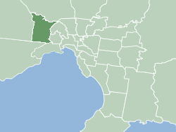
 Map of Melbourne showing City of Brimbank | |||||||||||||
| Population | 199,432 (2015)[1] (22nd) | ||||||||||||
| • Density | 1,617.5/km2 (4,189.2/sq mi) | ||||||||||||
| Established | 1994 | ||||||||||||
| Area | 123.3 km2 (47.6 sq mi) | ||||||||||||
| Mayor | Brimbank currently has administrators. | ||||||||||||
| Council seat | Sunshine | ||||||||||||
| Region | West Metropolitan Melbourne | ||||||||||||
| State electorate(s) | |||||||||||||
| Federal Division(s) | |||||||||||||
 | |||||||||||||
| Website | City of Brimbank | ||||||||||||
| |||||||||||||
The City of Brimbank is a local government area located within the metropolitan area of Melbourne, Victoria, Australia. It comprises the western suburbs between 10 and 20 km west and northwest from the Melbourne city centre.
The City has an area of 123 km² and at the 2011 Census, Brimbank had a population of 182,735.
History
The Wurundjeri people have been the custodians of the land in the Port Phillip Bay region, including the current City of Brimbank, for over 40,000 years before European settlement. Brimbank lies within the area occupied by the Kurung-Jang-Balluk and Marin-Balluk clans of the Wurundjeri people (also known as the Woiwurung language group) who form part of the larger Kulin Nation. Other groups who occupied land in the area include the Yalukit-Willam and Marpeang-Bulluk clans.
Brimbank was founded on 15 December 1994 during the amalgamations of local councils by the Kennett Liberal government. It was formed after the merger of the former Cities of Keilor and Sunshine. It was named after Brimbank Park in Keilor, which itself was named for the practice of local farmers driving livestock "around the brim of the bank" of the Maribyrnong River.[2]
Wards and councillors
The Local Government Act to dismiss Council was passed by the Victorian Parliament on 12 November 2009. As a result, the Minister for Local Government, Richard Wynne, appointed three administrators – Mr Peter Lewinsky, Ms Joanne Anderson and Ms Meredith Sussex AM – for a three-year period.[3] In 2012, the State government decided to extend the period of administration. The three administrators appointed were Mr Peter Lewinsky, Ms Jane Nathan and Mr John Watson (Chair of Administrators).[4] In March 2014 Mr John Tanner replaced Mr Peter Lewinsky.[5]
For electing councillors Brimbank is divided into the following wards:
- Grasslands Ward (includes the suburbs of Albanvale, Cairnlea, Kings Park, Deer Park and St Albans West) with 3 Councillors.
- Harvester Ward (includes the suburbs of Albion, Ardeer, Brooklyn, Derrimut, Sunshine, Sunshine North and Sunshine West) with 3 Councillors.
- Horseshoe Bend Ward (includes the suburbs of Keilor Park, Keilor East, Kealba, Tullamarine, St Albans East, Keilor and Tullamarine) with 2 Councillors.
- Taylors Ward (includes the suburbs of Calder Park, Keilor North, Keilor Lodge, Keilor Downs, Taylors Lakes, Delahey, Sydenham and Hillside) with 3 Councillors.
Mayors
- Cr John Hedditch (2016)
- Cr Troy Atanasovski (2009)
- Cr Sam David (2008)
- Cr Margaret Giudice (2007)
- Cr Natalie Suleyman (2006)
- Cr Natalie Suleyman (2005)
- Cr Sam David (2004)
Suburbs
- Albanvale
- Albion
- Ardeer
- Brooklyn (shared with the City of Hobsons Bay)
- Cairnlea
- Calder Park
- Deer Park
- Delahey
- Derrimut
- Hillside (shared with the Shire of Melton)
- Kealba
- Keilor
- Keilor Downs
- Keilor East (shared with the City of Moonee Valley)
- Keilor Lodge
- Keilor North
- Keilor Park
- Kings Park
- St Albans
- Sunshine (see Sunshine Residents and Ratepayers Association)
- Sunshine North
- Sunshine West
- Sydenham
- Taylors Lakes
- Tullamarine (shared with the Cities of Hume & Moreland)
References
- ↑ "3218.0 – Regional Population Growth, Australia, 2014–15". Australian Bureau of Statistics. Retrieved 29 September 2016.
- ↑ http://www.parkweb.vic.gov.au/1park_display.cfm?park=72
- ↑ http://www.premier.vic.gov.au/component/content/article/8736.html
- ↑ "Brimbank council troika complete". Brimbank Weekly. Fairfax. Retrieved 17 March 2013.
- ↑ http://www.brimbank.vic.gov.au/News_Updates/Media_Releases_2014/March_2014/Brimbank_City_Council_welcomes_announcement_of_third_Administrator
External links
- Official website
- Metlink local public transport map
- City of Brimbank at the Local Government Victoria website
Coordinates: 37°45′S 144°48′E / 37.750°S 144.800°E