Sirá
| Sira | |||
|---|---|---|---|
| Municipality | |||
 | |||
| |||
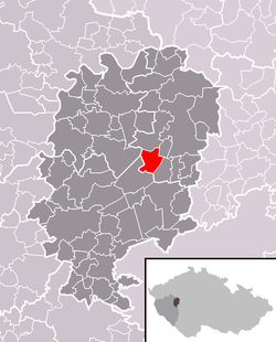 Location in Rokycany District | |||
 Sira Location in the Czech Republic | |||
| Coordinates: 49°48′59″N 13°44′11″E / 49.81639°N 13.73639°ECoordinates: 49°48′59″N 13°44′11″E / 49.81639°N 13.73639°E | |||
| Country |
| ||
| Region | Plzeň | ||
| District | Rokycany | ||
| Area | |||
| • Total | 6.43 km2 (2.48 sq mi) | ||
| Elevation | 497 m (1,631 ft) | ||
| Population (1.1.2016) | |||
| • Total | 136 | ||
| • Density | 21/km2 (55/sq mi) | ||
| Postal code | 337 01 | ||
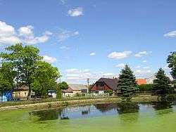
Sirá is a village and municipality (obec) in Rokycany District in the Plzeň Region of the Czech Republic.
The municipality covers an area of 6.43 square kilometres (2.48 sq mi), and has a population of 105 (as at 3 July 2006).
Sirá lies approximately 14 kilometres (9 mi) north-east of Rokycany, 28 km (17 mi) east of Plzeň, and 58 km (36 mi) south-west of Prague.
References
| Wikimedia Commons has media related to Sirá. |
This article is issued from Wikipedia - version of the 11/28/2016. The text is available under the Creative Commons Attribution/Share Alike but additional terms may apply for the media files.