South Bowers, Delaware
| South Bowers, Delaware | |
|---|---|
| Unincorporated community | |
|
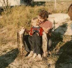
A father and son celebrating the day's catch. South Bowers, DE. 1976. | |
 South Bowers  South Bowers | |
| Coordinates: 39°3′26″N 75°23′51″W / 39.05722°N 75.39750°WCoordinates: 39°3′26″N 75°23′51″W / 39.05722°N 75.39750°W | |
| Country | United States |
| State | Delaware |
| County | Kent |
| Elevation | 3 ft (0.9 m) |
| Time zone | Eastern (EST) (UTC-5) |
| • Summer (DST) | EDT (UTC-4) |
| Area code(s) | 302 |
| GNIS feature ID | 214676[1] |
South Bowers is an unincorporated community in Kent County, Delaware, United States. South Bowers is located on the Delaware Bay on the south side of the Murderkill River opposite Bowers.[2]
The Island Field Site was listed on the National Register of Historic Places in 1972.[3]
References
- ↑ "South Bowers". Geographic Names Information System. United States Geological Survey.
- ↑ Delaware Department of Transportation (2008). Delaware Official Transportation Map (PDF) (Map). Dover: Delaware Department of Transportation.
- ↑ National Park Service (2010-07-09). "National Register Information System". National Register of Historic Places. National Park Service.
Municipalities and communities of Kent County, Delaware, United States | ||
|---|---|---|
| Cities | ||
| Towns | ||
| CDPs | ||
| Unincorporated communities |
| |
| Hundreds | ||
| Footnotes | ‡This populated place also has portions in an adjacent county or counties | |
This article is issued from Wikipedia - version of the 11/10/2016. The text is available under the Creative Commons Attribution/Share Alike but additional terms may apply for the media files.