South Ferry–Whitehall Street (New York City Subway)
| South Ferry–Whitehall Street | |||||||||||
|---|---|---|---|---|---|---|---|---|---|---|---|
| New York City Subway rapid transit station complex | |||||||||||
|
One of the entrances to the station | |||||||||||
| Station statistics | |||||||||||
| Address |
South Street & Whitehall Street New York, NY 10004 | ||||||||||
| Borough | Manhattan | ||||||||||
| Locale | Battery Park and Financial District | ||||||||||
| Coordinates | 40°42′09″N 74°00′46″W / 40.702472°N 74.012833°WCoordinates: 40°42′09″N 74°00′46″W / 40.702472°N 74.012833°W | ||||||||||
| Division | A (IRT), B (BMT) | ||||||||||
| Line |
BMT Broadway Line IRT Broadway–Seventh Avenue Line | ||||||||||
| Services |
1 N R W | ||||||||||
| Transit connections |
| ||||||||||
| Other information | |||||||||||
| Opened | March 16, 2009[1] | ||||||||||
| Traffic | |||||||||||
| Passengers (2015) |
8,750,364 (station complex)[2] | ||||||||||
| Rank | 40 out of 422 | ||||||||||
| |||||||||||
| |||||||||||


South Ferry–Whitehall Street is a New York City Subway station complex in the Manhattan neighborhood of Financial District, under Battery Park. The complex is shared by the IRT Broadway–Seventh Avenue Line and the BMT Broadway Line. It is served by the:
Formerly two unconnected stations, the 2009 completion of the new South Ferry IRT terminal added a free transfer between the 1 and the N, R, and W trains at the older Whitehall Street station. In 2013, the MTA also added a connection to the old South Ferry station while the new station was closed.
This station complex is the third on the site to bear the name South Ferry. The second, opened from 1905 to 2009, was a Balloon loop that served the IRT Broadway–Seventh Avenue and IRT Lexington Avenue Lines. The loop was replaced by a newer station in 2009, but reopened to replace its successor in 2013. The first was an elevated station opened from 1877 to 1950, and served the former IRT Ninth, Sixth, Third, and Second Avenue lines.
Station layout
| G | Street Level | Exit / Entrance (Elevator at SW corner of Whitehall and State Streets. Note: Elevator out of service) |
| B1 Loop platforms |
Side platform, not in service | |
| Separating wall | ||
| Inner loop | → | |
| Outer loop | → | |
| Side platform, doors open on the right for the first five cars only | ||
| Mezzanine | to entrances/exits, station agent, MetroCard vending machines | |
| B2 | Mezzanine | Passageway between platforms |
| B3 Broadway Line platforms |
Northbound | ← ← |
| Island platform, doors will open on the left, right | ||
| Center track | ← → | |
| Island platform, doors will open on the left, right | ||
| Southbound | → → | |
| B4 Seventh Avenue Line platform | ||
| Track 4 | → No regular service ← | |
| Island platform, not in service | ||
| Track 1 | →No regular service ← | |
Entrances and Exits
Entrances and exits are located at the following places:[3]
- Two staircases at the west side of Whitehall and Stone Streets, east of the Alexander Hamilton U.S. Custom House and National Museum of the American Indian
- One staircase at the northeast corner of Whitehall and Stone Streets
- Two staircases at the southwest corner of Whitehall and Water Streets
-
 One set of staircase/escalators and one elevator northwest of the Staten Island Ferry Whitehall Terminal
 - One set of staircase/escalator outside of the bus stop at the southeast corner of Water and State Streets
- One staircase on the southwest side of State Street, south of the intersection with Pearl Street
IRT Broadway–Seventh Avenue Line platform
Old South Ferry station loop platforms (1905–2009, 2013–present)
| South Ferry | |||||||
|---|---|---|---|---|---|---|---|
| New York City Subway rapid transit station | |||||||
|
Outer loop platform on reopening day (April 4, 2013). | |||||||
| Station statistics | |||||||
| Division | A (IRT) | ||||||
| Line | IRT Broadway–Seventh Avenue Line, IRT Lexington Avenue Line | ||||||
| Services |
1 | ||||||
| Structure | Underground | ||||||
| Platforms | originally 2 side platforms, the inner platform is walled off | ||||||
| Tracks | 2 balloon loops | ||||||
| Other information | |||||||
| Opened |
July 19, 1905 (outer loop) July 1, 1918 (inner loop) April 4, 2013 (outer loop reopening) | ||||||
| Closed |
March 16, 2009 (outer loop) February 13, 1977 (inner loop) | ||||||
| Station succession | |||||||
| Next north |
Rector Street: 1 Bowling Green: no regular service | ||||||
| Next south |
(Terminal): 1 | ||||||
| |||||||
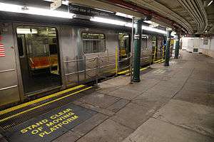
The South Ferry loops, used by the 1 train as of April 2013, are two side platforms (the inner one is walled off) on curved balloon loop tracks; however, free transfers were unavailable between the platforms and each platform was meant to be served by its own line. The most recent configuration using both tracks consisted of the IRT Broadway–Seventh Avenue Line on the outer loop platform and the IRT Lexington Avenue Line on the inner loop platform. Both stations are individually named South Ferry due to their connection to Manhattan's South Ferry; the name "South Ferry loops" is used to distinguish these platforms from the successor station. The newer island platform station was used by the Broadway–Seventh Avenue Line's 1 service from 2009 to 2012 until it was damaged by Hurricane Sandy. The outer loop platform reopened on April 4, 2013, to provide temporary replacement service.[4][5]
Outer platform
On July 10, 1905,[6] the outer South Ferry platform was the first of the two platforms to open and was an extension of the original trunk line of the Interborough Rapid Transit Company. The inner track existed when the station was built, but only as a storage track. When the "H" system of the IRT opened on July 1, 1918, Broadway–Seventh Avenue Line trains used the outer platform while the inner platform was opened for IRT Lexington Avenue Line trains which used the original trunk line in Lower Manhattan.
Services on the Broadway–Seventh Avenue Line, including the 1 and 9 trains (the latter of which was a rush-hour skip-stop duplicate of the former from 1989–2005), have used the outer platform as a terminal station since its inception, except for two relatively short periods of time. The first period was between September 2001 and September 2002 since the main branch south of Chambers Street was impassable after the September 11 attacks. The second was from March 16, 2009, when the new South Ferry station opened for 1 train passengers, to April 4, 2013, when the outer platform reopened with a transfer to the BMT section of the station complex. The newer station, located underneath this one, allowed a free transfer to the BMT station whereas neither of this station's platforms originally did.[7]
Station features
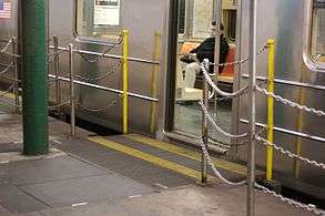
The outer platform serves 1 trains at all times and is the station's only operational platform. The platform accommodates the first five cars of a train, but the rear five cars of a 10-car 1 train cannot load or unload.[6] In addition, spray nozzles are required to lubricate the track to reduce the friction caused by the tight curve, which slows train operation and generates a loud metallic scraping noise. Because of the curve, gap fillers were required, and are still used, to bridge the gap between the platform and the doors.[6][8] The now-automated gap fillers previously required manual operation, with a foreman and at least two train crew, all of who could directly see each other; the train crew had to give a signal to the foreman, who pulled a 4 to 5 feet (1.2 to 1.5 m) tall wooden lever to manually extend and retract the gap fillers.[9]
The platform featured an oak ticket booth and an oak-cased clock from the Self-Winding Clock Company of New York. Evidence of the now-demolished ticket booth is a Beaux Arts design engraved on the ceiling.[9] The platform also features station tiling by Heins & LaFarge, who designed the station plaque in a sans-serif font. The walls are made of small white rectangular tiles, except for the bottom 3 feet (0.91 m), which is marble.[9] There are also fifteen ceramic plaques toward the top of the platform wall, all of which depict a sloop in the New York Harbor to signify the station's location and use. The top of the wall also includes festooned garlands and station monograms, in addition to ceramic trim where the wall intersects the ceiling. The station artwork on the original exit's landing is a 1990 mural, "South Sails", by former MTA Arts & Design director Sandra Bloodworth.[9]
Replacement and restoration
In order to eliminate this special operation, the new station was built as a two-track, full (10-car)-length island platform on a less severe curve, permitting the operation of a typical terminal station.[6][10] The MTA claimed that the new station saved four to six minutes of a passenger's trip time and increased the peak capacity of the 1 service to 24 trains per hour, as opposed to 16 to 17 trains per hour with the loop station.[11]
The platform's only point of egress was within the Staten Island Ferry Whitehall Terminal and was not ADA-accessible; originally, the exits consisted solely of two stairs that led toward the ferry terminal.[9] By contrast, the successor station is fully accessible (although its transfer to the BMT Broadway Line is not) and has three entrances; the main entrance is across from the ferry terminal building's entrance.[10] After Hurricane Sandy in late October 2012, the outer loop was brought back into service in order to turn trains uptown after terminating at Rector Street, since the replacement station suffered extensive flooding damage and closed for repairs; the station is expected to reopen in the summer of 2017.[12] After a few months, the MTA decided to reopen the loop station as an interim terminal to restore the connection from 1 service to the Staten Island Ferry. The station reopened on April 4, 2013, with a connection to Whitehall Street.[4][5][13]
Inner platform
The inner platform opened for IRT Lexington Avenue Line passengers on July 1, 1918, as that line's service was moved from the outer platform. This platform has an even sharper curve than the outer platform, and only the center doors opened here, with special arched openings in a wall between the platform and track at the locations of the doors.
In the late 1950s, when the IRT division began to use mostly R-type cars which could not have only the center doors opened, 5 trains (which ended at South Ferry evenings and weekends only) and 6 trains (which ended at South Ferry late nights) were rerouted to the outer loop. The Bowling Green–South Ferry shuttle, which ran weekdays and at first also late nights, continued to use the inner loop, running to the west platform at Bowling Green until 1977, when the inner platform was closed and Lexington Avenue trains stopped using the outer loop. Specially modified R12 cars were used starting in the late 1960s until the service ended. These cars had two different door controls; the first opened the outer two sets of doors while the second opened the center set of doors only. There was no free transfer between the inner loop and the outer loop platforms.
The inner track is used to turn 5 trains when they terminate at Bowling Green on weekday evenings and weekends.
New South Ferry station (2009–2012)
| South Ferry no regular service | |
|---|---|
| Closed New York City Subway rapid transit station | |
|
Station condition as of January 2013 | |
| Station statistics | |
| Division | A (IRT) |
| Line | IRT Broadway–Seventh Avenue Line |
| Services | no regular service |
| Structure | Underground |
| Platforms | 1 island platform |
| Tracks | 2 |
| Other information | |
| Opened | March 16, 2009[1] |
| Closed | October 28, 2012[14] |
| Rebuilt | 2017 (planned)[15] |
| Accessible |
|
| Station succession | |
| Next north | Rector Street: no regular service |
| Next south | (Terminal): no regular service |
|
| |
| Next | Chambers Street: no regular service |
| Next | none: no regular service |
The South Ferry station, which serves the IRT Broadway–Seventh Avenue Line exclusively, has two tracks and one island platform. The two tracks end at bumper blocks at the south end of the platform. This station was built as a replacement for the loop station, which was relegated to being used for turn-arounds once the new station opened. Unlike the loop station, this station only can access IRT Broadway–Seventh Avenue Line local trains, and does not connect with the Lexington Avenue Line.
The new station, which is located underneath the loop station, is designed as an ADA-accessible, two-track terminal, which allows all ten cars of the train to platform and all doors to be opened. The new station offers three street entrances (the loop station originally had only one before it reopened with a connection to the South Ferry–Whitehall Street complex in 2013) and has added a free transfer to the Whitehall Street–South Ferry station on the BMT Broadway Line. Landscaping for Peter Minuit Plaza was completed in May 2010.[16]
Construction
In 2003, money was allocated for the new station's construction, and in 2005, construction commenced on the new station.[17] Initially, the station's construction had been opposed because of the high cost and low perceived time savings.[18]
On December 8, 2005, New York City authorities announced that builders working on the new station had found the remains of a 200-year-old stone wall. After archaeological analysis, it was widely reported to be the oldest man-made structure still in place in Manhattan. Four walls and over 250,000 individual artifacts were found in the excavation of this subway station. A portion of one wall was placed on temporary display inside Castle Clinton.[19]
On December 11, 2008, the New York Times and the cable news channel NY1 reported that the new station was essentially finished. It features monumental artwork, See it split, see it change,[20] consisting of fused glass wall, stone mosaic, and a stainless steel fence. The artwork by artists Doug & Mike Starn depicting Manhattan topography is installed in the mezzanine.[21]
Originally budgeted at $400 million, the new South Ferry station cost a total of $530 million, with most of the money being a grant from the Federal Transit Administration earmarked for World Trade Center reconstruction.[6] In January 2009, the opening was delayed because the tracks were too far from the edge of the platform. The problem was corrected and the station opened on March 16, 2009.[22][23] Other delays were attributed to leaks in the station.[24] It was the first new subway station completed since 1989 when the IND 63rd Street Line stations opened.[lower-alpha 1] On April 16, 2009, MTA Capital Construction awarded a $19.2 million contract to Tully Construction Company to reconstruct Peter Minuit Plaza, which is above the station.[26]
After the station opened, a long portion of the excavated historic wall was embedded permanently into the wall of the entrance to the newly constructed station. "This wall most likely is a portion of the gun batteries that once protected the city in the late 17th and 18th centuries and gave rise to the modern park name," said Robert Tierney, chairman of the New York City Landmarks Preservation Commission. The city and the New York City Transit Authority plan to work together to preserve the remains, which were described as "an important remnant of the history of New York City."[19]
Post-Hurricane Sandy closure
On October 29, 2012, the new South Ferry station suffered extensive flooding damage caused by Hurricane Sandy. The station was flooded in up to 80 feet (24 m) of salt water,[27] submerging it from the track level to the mezzanine, and turned the station into a "large fish tank," as then-MTA chairman Joseph Lhota described it.[14] As a result, this section of the complex was closed until further notice. The MTA estimated that repairs would cost $600 million and might continue until 2016.[14][28] The terminal for the routes serving the station was moved back to Rector Street until the old loop station could be put back into service. The old loop station reopened on April 4, 2013, as a temporary replacement until the new station is restored to revenue service.[4][5][13] The connection between the loop station and the rest of the station necessitated the temporary removal of a 20-foot (6.1 m) section of the See it split, see it change artwork.[29]
The station is expected to reopen in the summer[12] of 2017[27][30] after renovations, signal room relocations, and extensive waterproofing work.[31] The signal room itself could be delayed until 2019. The $194 million contract was awarded on December 8, 2014, and the station is currently undergoing extensive reconstruction, including the installation of retractable floodgates at exits and entrances; sealing vents, manholes, hatches, conduits, and ducts; and cleaning up the station.[27] The renovation itself costs $345 million.[12] These improvements necessitated the closure of the station complex's main entrance for almost a year starting in October 2015.[32]
Gallery
- Old station
 Movable gap filler at station
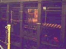 The closed inner platform as seen from the outer platform
 Mezzanine
 Mosaic tile name tablet
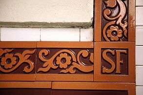 Mosaics that bear the initials of the station name
 One of the many boat mosaics within the station
 Looking down the platform in 2016.
 The former
 train at the outer platform in 2004
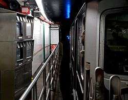 Conductor controls the whole length of the curved platform using monitors
- New station
 The platform view
 A train at the platform
 New artwork
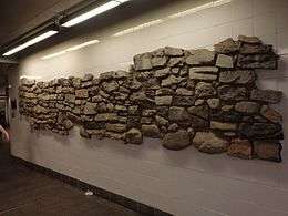 Excavated wall
.jpg) After Hurricane Sandy, in January 2013
After Hurricane Sandy, in January 2013
- Entrances
 Newly renovated entrance inside the Staten Island Ferry Terminal in May 2005
 Entrance constructed for new station
.jpg) New station's damaged fare control area in January 2013
New station's damaged fare control area in January 2013.jpg) New entrance to old station, opened in May 2013
New entrance to old station, opened in May 2013
BMT Broadway Line platforms
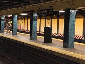
| Whitehall Street–South Ferry | |||||||||
|---|---|---|---|---|---|---|---|---|---|
| New York City Subway rapid transit station | |||||||||
 | |||||||||
| Station statistics | |||||||||
| Division | B (BMT) | ||||||||
| Line | BMT Broadway Line | ||||||||
| Services |
N R W | ||||||||
| Structure | Underground | ||||||||
| Platforms |
2 island platforms cross-platform interchange | ||||||||
| Tracks | 3 (2 in regular service) | ||||||||
| Other information | |||||||||
| Opened | September 20, 1918 | ||||||||
| Station succession | |||||||||
| Next north |
Rector Street: N (Terminal): R | ||||||||
| Next south |
Court Street: N (Terminal): W | ||||||||
| |||||||||
Whitehall Street–South Ferry[33] on the BMT Broadway Line has three tracks and two island platforms. The outer tracks continue south into the Montague Street Tunnel to the BMT Fourth Avenue Line in Brooklyn. The center track, used to terminate late-night R trains from Brooklyn[34] and weekday W trains from Queens,[35] merges with the outer tracks at either end of the station. However, select rush hour and late evening W trains continue beyond this station and terminate at 86th Street on the Sea Beach Line. The station is rather deep, as much of it goes under Bowling Green on the IRT Lexington Avenue Line. The fare control area and transfer to the IRT Broadway – Seventh Avenue Line platforms are at the extreme south end of the station, with additional exits at the north end. Both platforms are approximately 12–15 feet (3.7–4.6 m) wide, enough to fit several narrow stairways along the platform's length; this is why, although the IRT Broadway – Seventh Avenue Line's island platform is wheelchair-accessible, the BMT Broadway Line's platforms are not.
South of this station, a pair of bellmouths exists, allowing for a connection to a never-built East River tunnel south of the Montague Street Tunnel, going towards the proposed DeKalb Avenue bypass, using the old LIRR Atlantic Avenue Tunnel or under another street in Brooklyn. Further south is a flying junction joining from Broad Street on the BMT Nassau Street Line. Also south of this station, the emergency exit from the Montague Street Tunnel is located in the Nassau Street Connection which means before the Nassau Street Line was built, the emergency exit was actually in the bellmouth for the proposed line. The bellmouth was visible for years until it was used by the Nassau Street Connection when the entire line opened in 1931.
When this station opened on September 20, 1918, it was the terminal for the Broadway Line until the connection to Brooklyn opened in March 1920.[36]
On January 6, 1994, Automated Fare Collection turnstiles went into service at this station, and at the Wall Street station.[37]
Gallery
 An
An train rushing into the station
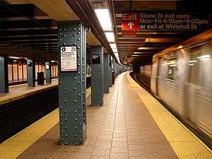 Looking down the platform
.jpg) Entrance, shuttered during Hurricane Sandy
Entrance, shuttered during Hurricane Sandy
Notable places nearby
- Downtown Manhattan Heliport
- Staten Island Ferry's Whitehall Street Ferry Terminal
- Ferries to Statue of Liberty, Ellis Island, and Governors Island
- Other places in the neighborhood
Notes
- ↑ However, the South Ferry station did not qualify as a completely new subway station, as it was connected to a pre-existing station. On the other hand, the 34th Street–Hudson Yards station, which opened in 2015, is the first completely new subway station since 1989, since it is standalone and does not connect to any pre-existing stations.[25]
References
- 1 2 MTA Opens New South Ferry Station Retrieved March 16, 2009
- ↑ "Facts and Figures: Annual Subway Ridership". Metropolitan Transportation Authority. Retrieved 2016-04-19.
- ↑ "MTA Neighborhood Maps: Lower Manhattan" (PDF). mta.info. Metropolitan Transportation Authority. 2016. Retrieved 27 June 2016.
- 1 2 3 "Old South Ferry Station to Reopen for Service in early April" (Press release). Metropolitan Transportation Authority. March 8, 2013. Retrieved May 5, 2016.
- 1 2 3 Flegenheimer, Matt (2013-03-08). "Storm Damage Prompts Return of Old Subway Stop". nytimes.org. The New York Times. Retrieved 2016-07-23.
- 1 2 3 4 5 Neuman, William (December 11, 2008). "At the Last Subway Stop, a New Exit Strategy". The New York Times. Retrieved June 7, 2009.
- ↑ "MTA Opens New South Ferry Subway Terminal" (Press release). Metropolitan Transportation Authority. March 16, 2009. Retrieved June 7, 2009.
- ↑ MTA South Ferry FEIS, 2004, p.1-5
- 1 2 3 4 5 Kevin Walsh (December 2008). "LAST DAYS AT SOUTH FERRY". Forgotten NY. Retrieved 7 July 2015.
- 1 2 Yates, Maura (December 12, 2008). "New subway station has plenty of upside". Staten Island Advance. Retrieved June 7, 2009.
- ↑ Cuza, Bobby (December 11, 2008). "Brand-New South Ferry Station To Open Soon". NY1. Retrieved June 7, 2009.
- 1 2 3 "mta.info | Superstorm Sandy: One Year Later". web.mta.info. Metropolitan Transportation Authority. Retrieved 2016-07-23.
- 1 2 "With Old South Ferry Reopening, a Connection Restored". Retrieved 2016-07-23.
- 1 2 3 "Flood, Rebuild, Repeat: Are We Ready for a Superstorm Sandy Every Other Year?". Mother Jones. July–August 2013.
- ↑ For South Ferry, mitigation and a new signal room
- ↑ "South Ferry Terminal Project". MTA Capital Construction. Retrieved 2015-10-31.
- ↑ "About FTA". FTA. 2003-12-03. Retrieved 2015-10-31.
- ↑ Young, Dana. "Opposition to South Ferry subway project grows". DOWNTOWN EXPRESS | The Newspaper of Lower Manhattan. Retrieved 2015-10-31.
- 1 2 "Unearthing Colonial New York: South Ferry Project Yields 65K Artifacts". AM New York. February 26, 2010. Retrieved May 22, 2010.
- ↑ "MTA - Arts & Design | NYCT Permanent Art". web.mta.info. Retrieved 2016-07-23.
- ↑ "New subway station has plenty of upside - SILive.com". www.silive.com. Retrieved 2016-07-23.
- ↑ NEW AND OLD DOWNTOWN: Wall Street and South Ferry. Forgotten NY. Retrieved 2014-06-11.
- ↑ "MTA opens new $530M South Ferry station". Retrieved 2016-07-21.
- ↑ "Staten Island commuters counting down days until new subway station opens". SILive.com. 2009-03-11. Retrieved 2015-10-31.
- ↑ Fitzsimmons, Emma G. (September 12, 2015). "Subway Station to Open This Weekend, Bringing 7 Line to Far West Side". The New York Times. Retrieved September 13, 2015.
- ↑ "MTA Capital Construction - Procurement". web.mta.info. Retrieved 2016-10-23.
- 1 2 3 Donohue, Peter (8 December 2014). "$194 million contract awarded to upgrade South Ferry subway station". Daily News. NYDailyNews.com. Retrieved 7 February 2015.
- ↑ Restoring South Ferry Station
- ↑ "mta.info | Superstorm Sandy: One Year Later". web.mta.info. Retrieved 2016-07-24.
- ↑ Furfaro, Danielle (2016-10-29). "Sandy-ravaged subway entrance to be closed 9 months". New York Post. Retrieved 2015-10-31.
- ↑ Kabak, Benjamin (28 April 2014). "Board docs: South Ferry reopening still targeting mid-2016". Second Avenue Sagas. Retrieved 28 April 2014.
- ↑ Rivoli, Dan (2016-10-29). "South Ferry station entrance to close for more than 9 months". NY Daily News. Retrieved 2015-10-31.
- ↑ "Subway Map" (PDF). Metropolitan Transportation Authority. November 2016. Retrieved 2016-11-07.
- ↑ "R Subway Timetable, Effective November 7, 2016" (PDF). New York Metropolitan Transportation Authority. Retrieved November 7, 2016.
- ↑ "W Subway Timetable, Effective November 7, 2016" (PDF). New York Metropolitan Transportation Authority. Retrieved November 7, 2016.
- ↑ Legislative Documents. J.B. Lyon Company. 1920-01-01.
- ↑ "About NYC Transit - History". 2002-10-19. Retrieved 2016-09-18.
Further reading
- Lee Stokey. Subway Ceramics : A History and Iconography. 1994. ISBN 978-0-9635486-1-0
External links
| Wikimedia Commons has media related to South Ferry – Whitehall Street (New York City Subway). |
|
|
- Track diagram - The New York Times
- nycsubway.org – IRT West Side Line: South Ferry (loops)
- nycsubway.org – IRT West Side Line: South Ferry
- nycsubway.org – BMT Broadway Line: Whitehall Street–South Ferry
- nycsubway.org — See It Split, See It Change mosaic by Doug and Mike Starn (2007)
- nycsubway.org — Passages mosiac by Frank Giorgini (2000)
- Abandoned Stations — Bowling Green & South Ferry platforms
- Video of loops taken in 1997-1998.
- South Ferry Terminal Project — Official MTA South Ferry Station Project Page
- MTA's Arts For Transit — South Ferry (IRT Broadway–Seventh Avenue Line)
- MTA's Arts For Transit — Whitehall Street (BMT Broadway Line)
- entrance and elevator in front of the Staten Island Ferry Whitehall Terminal from Google Maps Street View
- Whitehall Street and Stone Street entrance from Google Maps Street View
- Whitehall Street and State Street entrance from Google Maps Street View
- State Street entrance from Google Maps Street View
- Old loops' entrance from Google Maps Street View
- Loop platform from Google Maps Street View
- Loop station staircase from Google Maps Street View
- BMT platforms from Google Maps Street View
- BMT lobby from Google Maps Street View
- BMT escalator from Google Maps Street View