Southport, Maine
| Southport, Maine | |
|---|---|
| Town | |
|
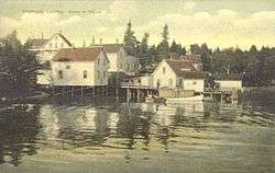
Southport Landing in 1910 | |
 Location in Lincoln County and the state of Maine. | |
| Coordinates: 43°49′23″N 69°40′0″W / 43.82306°N 69.66667°W | |
| Country | United States |
| State | Maine |
| County | Lincoln |
| Incorporated | 1842 |
| Area[1] | |
| • Total | 23.16 sq mi (59.98 km2) |
| • Land | 5.38 sq mi (13.93 km2) |
| • Water | 17.78 sq mi (46.05 km2) |
| Elevation | 62 ft (19 m) |
| Population (2010)[2] | |
| • Total | 606 |
| • Estimate (2012[3]) | 599 |
| • Density | 112.6/sq mi (43.5/km2) |
| Time zone | Eastern (EST) (UTC-5) |
| • Summer (DST) | EDT (UTC-4) |
| ZIP code | 04576 |
| Area code(s) | 207 Exchange: 633 |
| FIPS code | 23-71955 |
| GNIS feature ID | 0582737 |

Southport is a town in the county of Lincoln, state of Maine, in the United States. The population was 606 at the 2010 census. It includes the villages of Southport, West Southport, Cape Newagen, and Squirrel Island. The majority of the town's residents live on Southport Island.
History
Cape Newagen, at the southern tip of the island, was an early European fishing outpost. Southport was part of Boothbay until it separated on February 12, 1842.[4] Originally called Townshend after Lord Townshend, the name was changed to Southport in 1850.[5]
Geography
According to the United States Census Bureau, the town has a total area of 23.16 square miles (59.98 km2), of which, 5.38 square miles (13.93 km2) of it is land and 17.78 square miles (46.05 km2) is water.[1] Southport is on Southport Island in the mouth of the Sheepscot River. The Town of Southport constitutes the whole of Southport Island.
It is crossed by state routes 27 and 238. It is connected by a green swing bridge to the adjacent municipality of Boothbay Harbor.
Demographics
| Historical population | |||
|---|---|---|---|
| Census | Pop. | %± | |
| 1850 | 543 | — | |
| 1860 | 708 | 30.4% | |
| 1870 | 684 | −3.4% | |
| 1880 | 679 | −0.7% | |
| 1890 | 533 | −21.5% | |
| 1900 | 527 | −1.1% | |
| 1910 | 409 | −22.4% | |
| 1920 | 272 | −33.5% | |
| 1930 | 412 | 51.5% | |
| 1940 | 405 | −1.7% | |
| 1950 | 435 | 7.4% | |
| 1960 | 416 | −4.4% | |
| 1970 | 473 | 13.7% | |
| 1980 | 598 | 26.4% | |
| 1990 | 645 | 7.9% | |
| 2000 | 684 | 6.0% | |
| 2010 | 606 | −11.4% | |
| Est. 2014 | 594 | [6] | −2.0% |
2010 census
As of the census[2] of 2010, there were 606 people, 316 households, and 195 families residing in the town. The population density was 112.6 inhabitants per square mile (43.5/km2). There were 1,051 housing units at an average density of 195.4 per square mile (75.4/km2). The racial makeup of the town was 96.5% White, 1.7% from two or more races, 1.3% Asian, 0.3% African American and 0.2% Native American. Latino of any race were 0.2% of the population.
There were 316 households of which 14.2% had children under the age of 18 living with them, 55.1% were married couples living together, 4.7% had a female householder with no husband present, 1.9% had a male householder with no wife present, and 38.3% were non-families. 33.2% of all households were made up of individuals and 18.4% had someone living alone who was 65 years of age or older. The average household size was 1.92 and the average family size was 2.38.
The median age in the town was 60.1 years. 12% of residents were under the age of 18; 2.3% were between the ages of 18 and 24; 13% were from 25 to 44; 35.6% were from 45 to 64; and 37% were 65 years of age or older. The gender makeup of the town was 48.5% male and 51.5% female.
2000 census
As of the census[8] of 2000, there were 684 people, 331 households, and 218 families residing in the town. The population density was 127.0 people per square mile (49.0/km²). There were 912 housing units at an average density of 169.3 per square mile (65.3/km²). The racial makeup of the town was 98.83% White, 0.58% Asian, and 0.58% from two or more races.
There were 331 households out of which 19.9% had children under the age of 18 living with them, 59.8% were married couples living together, 3.3% had a female householder with no husband present, and 34.1% were non-families. 29.9% of all households were made up of individuals and 14.5% had someone living alone who was 65 years of age or older. The average household size was 2.07 and the average family size was 2.52.
In the town the population was spread out with 14.6% under the age of 18, 3.5% from 18 to 24, 15.4% from 25 to 44, 35.7% from 45 to 64, and 30.8% who were 65 years of age or older. The median age was 53 years. For every 100 females there were 95.4 males. For every 100 females age 18 and over, there were 97.3 males.
The median income for a household in the town was $38,125, and the median income for a family was $52,750. Males had a median income of $35,500 versus $24,583 for females. The per capita income for the town was $33,481. About 4.2% of families and 6.8% of the population were below the poverty line, including 11.2% of those under age 18 and 3.3% of those age 65 or over.
Sites of interest
- Boothbay Register newspaper
- Cuckolds Light
- Hendricks Head Light
- Hendricks Hill Museum
- Southport Yacht Club
Notable people
- Ralph H. Cameron, US senator and congressman
- Rachel Carson, marine biologist, nature writer
- Wilder Hobson, writer, editor
- Hart Day Leavitt, teacher, jazz musician
- Gustaf Tenggren, illustrator
- Claggett Wilson, painter
References
- 1 2 "US Gazetteer files 2010". United States Census Bureau. Retrieved 2012-12-16.
- 1 2 "American FactFinder". United States Census Bureau. Retrieved 2012-12-16.
- ↑ "Population Estimates". United States Census Bureau. Retrieved 2013-07-06.
- ↑ Maine League of Historical Societies and Museums (1970). Doris A. Isaacson, ed. Maine: A Guide 'Down East'. Rockland, Me: Courier-Gazette, Inc. p. 325.
- ↑ Coolidge, Austin J.; John B. Mansfield (1859). A History and Description of New England. Boston, Massachusetts. p. 310.
- ↑ "Annual Estimates of the Resident Population for Incorporated Places: April 1, 2010 to July 1, 2014". Retrieved June 4, 2015.
- ↑ "Census of Population and Housing". Census.gov. Retrieved June 4, 2015.
- ↑ "American FactFinder". United States Census Bureau. Retrieved 2008-01-31.
Further reading
External links
- Town of Southport, Maine
- Southport Memorial Library
- Boothbay Register newspaper
- Boothbay Region Historical Society
- Epodunk profile
- Maine Genealogy: Southport, Lincoln County, Maine
Municipalities and communities of Lincoln County, Maine, United States | ||
|---|---|---|
| Towns |  | |
| Plantation | ||
| Gore | ||
| CDPs | ||
| Other villages | ||
Coordinates: 43°50′27″N 69°39′31″W / 43.84083°N 69.65861°W