Spinete
| Spinete | |
|---|---|
| Comune | |
| Comune di Spinete | |
 | |
 Spinete Location of Spinete in Italy | |
| Coordinates: 41°33′N 14°29′E / 41.550°N 14.483°ECoordinates: 41°33′N 14°29′E / 41.550°N 14.483°E | |
| Country | Italy |
| Region | Molise |
| Province / Metropolitan city | Province of Campobasso (CB) |
| Area | |
| • Total | 17.6 km2 (6.8 sq mi) |
| Elevation | 600 m (2,000 ft) |
| Population (2010) | |
| • Total | 1,384 |
| • Density | 79/km2 (200/sq mi) |
| Time zone | CET (UTC+1) |
| • Summer (DST) | CEST (UTC+2) |
| Postal code | 86020 |
| Dialing code | 0874 |
| Website | Official website |
Spinete is a comune (municipality) in the Province of Campobasso in the Italian region Molise, located about 15 kilometres (9 mi) west of Campobasso. As of 31 December 2004, it had a population of 1,437 and an area of 17.6 square kilometres (6.8 sq mi).[1]
Spinete borders the following municipalities: Baranello, Bojano, Busso, Casalciprano, Colle d'Anchise, Sant'Elena Sannita.
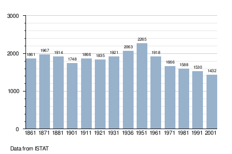
Demographic evolution
References
This article is issued from Wikipedia - version of the 5/19/2016. The text is available under the Creative Commons Attribution/Share Alike but additional terms may apply for the media files.