Srikalahasti
| Srikalahasti శ్రీకాళహస్తి Kalahasti | |
|---|---|
| Town | |
|
Srikalahasti aerial view | |
 Srikalahasti Location in Andhra Pradesh, India | |
| Coordinates: 13°46′N 79°42′E / 13.76°N 79.70°ECoordinates: 13°46′N 79°42′E / 13.76°N 79.70°E | |
| Country | India |
| State | Andhra Pradesh |
| District | Chittoor |
| Mandal | Srikalahasti |
| Area[1] | |
| • Total | 24.50 km2 (9.46 sq mi) |
| Population (2011)[2] | |
| • Total | 80,056 |
| • Density | 3,300/km2 (8,500/sq mi) |
| Languages | |
| • Official | Telugu |
| Time zone | IST (UTC+5:30) |
| Website |
oursrikalahasti |

Srikalahasti is a holy town in Chittoor district of the Indian state of Andhra Pradesh. It is a municipality and the mandal headquarters of Srikalahasti mandal in Tirupati revenue division.[3][4] The town is a part of Tirupati Urban Development Authority, which is located on the banks of the River Swarnamukhi.[5] The Srikalahasti Temple is one of the important ancient Shiva Temples of Southern India.
History

The Srikalahasti temple was originally built during Pallava period and current structures are built by Chola king Kulothunga Cholan I, II and III during the 11th century.
It is one of the ancient temples included in the Saiva pilgrimages and is fairly close to the famous hill temple of Lord Venkateshwara at Tirupati. A huge hundred pillared mantapam was built by Sri Krishnadevaraya of Vijayanagara dynasty during the 16th century, an important feature of this shrine. The historical reference to this temple occur in the works of Nakkeerar, a Tamil poet during the Tamil Sangam Dynasty. He called it as Southern Kailash. Nakkeera composed hundreds of Tamil stanzas to praise Srikalahasteeswara. Dhoorjati a Telugu poet native of this place and one among the ashtadiggajas of Sri Krishnadevaraya’s court composed hundred stanzas on Sri Kalahasteeswara.
Geography
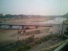
Srikalahasti is located at 13°45′N 79°42′E / 13.750°N 79.700°E on the bank of river Swarnamukhi. It is located 38 km north of Tirupati central.
Demographics
As of 2011 Census of India, the town had a population of 80,056. The total population constitute, 38,995 males and 41,061 females—a sex ratio of 1053 females per 1000 males, higher than the national average of 940 per 1000.[2][6] 8,224 children are in the age group of 0–6 years, of which 4,227 are boys and 3,997 are girls—a ratio of 946 per 1000. The average literacy rate stands at 78.66% (male 85.15%; female 72.57%) with 56,501 literates, significantly higher than the national average of 73.00%.[2][7]
Education
The primary and secondary school education is imparted by government, aided and private schools, under the School Education Department of the state.[8][9] The medium of instruction followed by different schools are English, Telugu.

Srikalahasthi has educational institutions ranging from Elementary schools to Engineering & Degree Colleges. Srikalahasteeswara Institute of Technology is an engineeried by Srikalahasteeswara Trust board. It is affiliated to J.N.T.U, Anantapur.
Economy
The town depends mainly on agriculture and tourism. The main crops are paddy, sugar cane and ground nuts. Hundreds of Kalamkari artists also bring some revenue. Pilgrims visiting the Venkateswara Temple, Tirumala also visit the Srikalahasti temple.
Transport
Srikalahasti railway station is on the Renigunta-Gudur section of Guntakal (GTL) Division of the South Central Railway (SCR). Andhra Pradesh State owned Bus services APSRTC operates buses from Tirupati, Chittoor and Nellore.
References
- ↑ "Srikalahasthi Municipality". Commissioner & Director of Municipal Administration. Municipal Administration and Urban Development Department, Govt. of Andhra Pradesh. Retrieved 19 August 2014.
- 1 2 3 "Census 2011". The Registrar General & Census Commissioner, India. Retrieved 1 September 2014.
- ↑ "Chittoor District Mandals" (PDF). Census of India. pp. 454, 510–11. Retrieved 19 June 2015.
- ↑ "District Census Handbook - Chittoor" (PDF). Census of India. pp. 22–23. Retrieved 20 January 2016.
- ↑ "Right to Information Act – 2005". Tirupati Urban Development Authority. Retrieved 1 September 2014.
- ↑ "Sex Ratio". The Registrar General & Census Commissioner, India. Retrieved 1 September 2014.
- ↑ "Chapter–3 (Literates and Literacy rate)" (PDF). Registrar General and Census Commissioner of India. Retrieved 3 September 2014.
- ↑ "School Eduvation Department" (PDF). School Education Department, Government of Andhra Pradesh. Retrieved 7 November 2016.
- ↑ "The Department of School Education - Official AP State Government Portal | AP State Portal". www.ap.gov.in. Retrieved 7 November 2016.
External links
| Wikimedia Commons has media related to Srikalahasti. |