St. Lucie Nuclear Power Plant
| St. Lucie Nuclear Power Plant | |
|---|---|
 | |
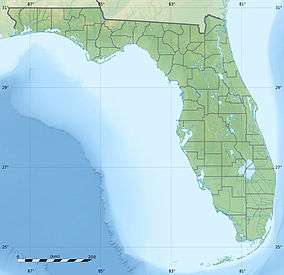
 Location of St. Lucie Nuclear Power Plant in Florida | |
| Country | United States |
| Location | Port St. Lucie, Florida |
| Coordinates | 27°20′55″N 80°14′47″W / 27.34861°N 80.24639°WCoordinates: 27°20′55″N 80°14′47″W / 27.34861°N 80.24639°W |
| Status | Operational |
| Commission date |
Unit 1: March 1, 1976 Unit 2: June 10, 1983[1] |
| Operator(s) | Florida Power & Light |
| Nuclear power station | |
| Reactor type | Pressurized water reactor |
| Reactor supplier | Combustion Engineering |
| Power generation | |
| Units operational | 2 x 1002 MW |
| Capacity factor | 64.9% |
| Average generation | 11,390 GWh |
|
Website www.fpl.com/environment/nuclear/about_st_lucie.shtml | |
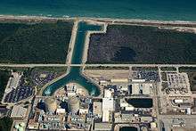
St. Lucie Nuclear Power Plant is a twin nuclear power station located on Hutchinson Island, near Port St. Lucie in St. Lucie County, Florida. Both units are Combustion Engineering pressurized water reactors. Florida Power & Light commissioned the station in 1976 and continues to operate the station. Minor shares of Unit 2 are owned by the Florida Municipal Power Agency (8.81%) and the Orlando Utilities Commission (6.08%).
The plant contains two nuclear reactors in separate containment buildings. However, the plant does not have the classic hyperboloid cooling towers found at many inland reactor sites; instead, it uses nearby ocean water for coolant of the secondary system.
In 2003 the Nuclear Regulatory Commission (NRC) extended the operating licenses of the St. Lucie units by twenty years, to March 1, 2036 for Unit 1 and April 6, 2043 for Unit 2.
Extended Power Uprate
In 2012, Extended Power Uprate modifications were completed, increasing the electric output from approximately 853 MW to 1,002 MW. The project involved replacing pipes, valves, pumps, heat exchangers, electrical transformers, and generators, some of which were original components of the plant.[2][3]
Surrounding population
The Nuclear Regulatory Commission defines two emergency planning zones around nuclear power plants: a plume exposure pathway zone with a radius of 10 miles (16 km), concerned primarily with exposure to, and inhalation of, airborne radioactive contamination, and an ingestion pathway zone of about 50 miles (80 km), concerned primarily with ingestion of food and liquid contaminated by radioactivity.[4]
The 2010 U.S. population within 10 miles (16 km) of Saint Lucie was 206,596, an increase of 49.7 percent in a decade, according to an analysis of U.S. Census data for msnbc.com. The 2010 U.S. population within 50 miles (80 km) was 1,271,947, an increase of 37.0 percent since 2000. Cities within 50 miles include Ft. Pierce (8 miles to city center) and West Palm Beach (42 miles to city center).[5]
Seismic risk
The Nuclear Regulatory Commission's estimate of the risk each year of an earthquake intense enough to cause core damage to the reactor at Saint Lucie was 1 in 21,739, according to an NRC study published in August 2010.[6][7]
See also
References
- ↑ Florida Nuclear Power Plants, eia.doe.gov
- ↑ http://www.myhometownnews.net/index.php?id=99433
- ↑ http://www.nrc.gov/reading-rm/doc-collections/news/2012/12-105.pdf
- ↑ http://www.nrc.gov/reading-rm/doc-collections/fact-sheets/emerg-plan-prep-nuc-power-bg.html
- ↑ Bill Dedman, Nuclear neighbors: Population rises near US reactors, msnbc.com, April 14, 2011 http://www.msnbc.msn.com/id/42555888/ns/us_news-life/ Accessed May 1, 2011.
- ↑ Bill Dedman, "What are the odds? US nuke plants ranked by quake risk," msnbc.com, March 17, 2011 http://www.msnbc.msn.com/id/42103936/ Accessed April 19, 2011.
- ↑ http://msnbcmedia.msn.com/i/msnbc/Sections/NEWS/quake%20nrc%20risk%20estimates.pdf
External links
Plant in South Florida]
- "St. Lucie Nuclear Power Plant, Florida". U.S. Department of Energy (DOE). September 15, 2008. Retrieved 2008-11-17.
- "Saint Lucie 1 Pressurized Water Reactor". Operating Nuclear Power Reactors. U.S. Nuclear Regulatory Commission (NRC). February 14, 2008. Retrieved 2008-11-17.
- "Saint Lucie 2 Pressurized Water Reactor". Operating Nuclear Power Reactors. NRC. February 14, 2008. Retrieved 2008-11-17.