Steelton, Pennsylvania
| Steelton, Pennsylvania | |
|---|---|
| Borough | |
|
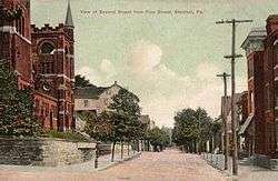
Second Street in 1910 | |
| Motto: "Our Renaissance Continues..." | |
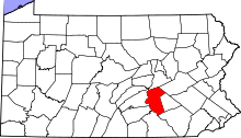
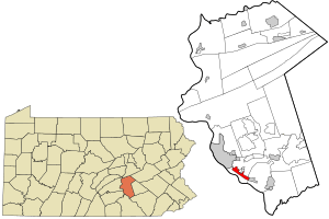 Location in Dauphin County and state of Pennsylvania. | |
| Coordinates: 40°13′52″N 76°49′56″W / 40.23111°N 76.83222°WCoordinates: 40°13′52″N 76°49′56″W / 40.23111°N 76.83222°W | |
| Country | United States |
| State | Pennsylvania |
| County | Dauphin |
| Settled | 1866 |
| Incorporated | 1880 |
| Government | |
| • Type | Borough Council |
| Area | |
| • Total | 1.9 sq mi (4.9 km2) |
| • Land | 1.9 sq mi (4.9 km2) |
| • Water | 0.0 sq mi (0.0 km2) |
| Elevation | 315 ft (96 m) |
| Population (2010) | |
| • Total | 5,990 |
| • Density | 3,160/sq mi (1,220.1/km2) |
| Time zone | Eastern (EST) (UTC-5) |
| • Summer (DST) | EDT (UTC-4) |
| ZIP code | 17113 |
| Area code(s) | 717 |
| Website |
www |
Steelton is a borough in Dauphin County, Pennsylvania, United States, 4 miles (6 km) southeast of Harrisburg. The population was 5,990 at the 2010 census.[1] The borough is part of the Harrisburg–Carlisle Metropolitan Statistical Area.
History
Steelton was incorporated as a borough on January 19, 1880. It was named from the steel industry contained within its borders.[2] The extensive works of the Pennsylvania Steel Company, later operated by Bethlehem Steel, are located along the Susquehanna River in Steelton. Also present at one time were brickyards, a flouring mill, and machine shops.
Steelton is the birthplace of Homer Litzenberg, the Korean War hero who commanded the 7th Marine Regiment during the Battle of Chosin Reservoir.
19 people were killed and 199 injured, when a Baseball Special train from Harrisburg to Philadelphia derailed at Steelton on July 28, 1962. Three of the nine cars landed in the Susquehanna River. A passing U.S. Navy drill team participated in the rescue efforts.[3]
Steelton High School was added to the National Register of Historic Places in 2011.[4]
Geography
Steelton is located in southern Dauphin County along the northeast bank of the Susquehanna River. It is bordered to the southeast by the borough of Highspire and to the northeast by the unincorporated communities of Enhaut and Bressler. To the northwest, the city limits of Harrisburg, the state capital, come within 0.3 miles (0.48 km) of the borough limits of Steelton; the city center is 4 miles (6 km) northwest of Steelton's center.
According to the United States Census Bureau, the borough has a total area of 1.9 square miles (4.9 km2), all of it land.[1]
Pennsylvania Route 230 (Front Street) is the main road through the borough, connecting Harrisburg to the northwest with Highspire and Middletown to the southeast. Steelton has two neighborhoods, Uptown and East End.
Demographics
| Historical population | |||
|---|---|---|---|
| Census | Pop. | %± | |
| 1880 | 2,447 | — | |
| 1890 | 9,250 | 278.0% | |
| 1900 | 12,086 | 30.7% | |
| 1910 | 14,246 | 17.9% | |
| 1920 | 13,428 | −5.7% | |
| 1930 | 13,291 | −1.0% | |
| 1940 | 13,115 | −1.3% | |
| 1950 | 12,574 | −4.1% | |
| 1960 | 11,266 | −10.4% | |
| 1970 | 8,556 | −24.1% | |
| 1980 | 6,484 | −24.2% | |
| 1990 | 5,152 | −20.5% | |
| 2000 | 5,858 | 13.7% | |
| 2010 | 5,990 | 2.3% | |
| Est. 2015 | 5,932 | [5] | −1.0% |
| Sources:[6][7][8][9] | |||
As of the census[8] of 2000, there were 5,858 people, 2,312 households, and 1,518 families residing in the borough. The population density was 3,215.6 people per square mile (1,242.7/km²). There were 2,533 housing units at an average density of 1,390.4 per square mile (537.4/km²). The racial makeup of the borough was 62.03% White, 31.12% African American, 0.22% Native American, 0.65% Asian, 0.03% Pacific Islander, 2.41% from other races, and 3.53% from two or more races. Hispanic or Latino of any race were 7.48% of the population. 15.0% were of German, 7.7% American, 6.0% Irish, 5.7% Italian and 5.4% Croatian ancestry according to Census 2000.
There were 2,312 households, out of which 33.0% had children under the age of 18 living with them, 38.1% were married couples living together, 22.0% had a female householder with no husband present, and 34.3% were non-families. 29.7% of all households were made up of individuals, and 13.7% had someone living alone who was 65 years of age or older. The average household size was 2.53 and the average family size was 3.13.
In the borough the population was spread out, with 28.8% under the age of 18, 7.8% from 18 to 24, 27.5% from 25 to 44, 19.9% from 45 to 64, and 16.0% who were 65 years of age or older. The median age was 36 years. For every 100 females there were 87.0 males. For every 100 females age 18 and over, there were 80.6 males.
The median income for a household in the borough was $34,829, and the median income for a family was $39,556. Males had a median income of $30,488 versus $24,701 for females. The per capita income for the borough was $16,612. About 9.1% of families and 11.8% of the population were below the poverty line, including 19.5% of those under age 18 and 3.1% of those age 65 or over.
Notable people
- Bull Behman, former NFL player and coach
- Troy Drayton, former NFL and Penn State football player
- Orrin C. Evans, pioneering African-American journalist and comic book publisher
- Don Falcone, musician and producer
- Jordan Hill, defensive tackle for Penn State and 2013 NFL draft to Seattle Seahawks
- Marne Intrieri, football offensive lineman
- Homer Litzenberg, lieutenant general
- Walter M. Mumma, congressman
- Allen Sangree, sports writer and war journalist
- Frank Sinkovitz, football center
- John Yovicsin, football player and coach
References
- 1 2 "Geographic Identifiers: 2010 Demographic Profile Data (G001): Steelton borough, Pennsylvania". U.S. Census Bureau, American Factfinder. Retrieved December 16, 2015.
- ↑ Notes and Queries, Historical, Biographical and Genealogical, Relating Chiefly to Interior Pennsylvania. Harrisburg Publishing Company. 1895. p. 15.
- ↑ U.S. Navy All Hands magazine December 1962, pp. 16-19.
- ↑ "National Register of Historic Places Listings". Weekly List of Actions Taken on Properties: 9/06/11 through 9/09/11. National Park Service. 2011-09-16.
- ↑ "Annual Estimates of the Resident Population for Incorporated Places: April 1, 2010 to July 1, 2015". Retrieved July 2, 2016.
- ↑ "Number of Inhabitants: Pennsylvania" (PDF). 18th Census of the United States. U.S. Census Bureau. Retrieved 22 November 2013.
- ↑ "Pennsylvania: Population and Housing Unit Counts" (PDF). U.S. Census Bureau. Retrieved 22 November 2013.
- 1 2 "American FactFinder". United States Census Bureau. Retrieved 2008-01-31.
- ↑ "Incorporated Places and Minor Civil Divisions Datasets: Subcounty Population Estimates: April 1, 2010 to July 1, 2012". U.S. Census Bureau. Retrieved 25 November 2013.
External links
- Borough of Steelton official website
- Historical Society of Dauphin County
- Images of the Steelton steel mill