Storm tides of the North Sea
A storm tide is a tide with a high flood period caused by a storm. Storm tides can be a severe danger to the coast and the people living along the coast. The water level can rise to more than 5 metres (17 ft) above the normal tide.
The North Sea, especially the Netherlands, northern Germany and Denmark is particularly susceptible to storm tides. The coastline of the German Bight forms an L-shape facing northwest. Also vulnerable is the southern North Sea between England and the Netherlands, where the sea shallows and is funnelled between the land. For the protection of the low-lying areas along the coast, long and high dike systems have been built. Storm tides are a regular occurrence in these areas; usually, there are several storm tides each winter. Most of them do not cause significant damage.
Effect on coast line
The Danish coastline changed following the flood of 1825; the North Jutlandic Island got separated from the Jutland Peninsula.[1]
Major storm tides
- 838, December 26, Netherlands, more than 2,400 deaths
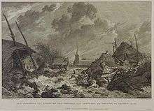
- 1014, September 28, Netherlands, several thousands of deaths[2]
- 1099, November 11, The Anglo-Saxon Chronicle states, that in London 'On the festival of St Martin, the sea flood sprung up to such a height and did so much harm as no man remembered that it ever did before'.[3]
- 1164, February 16, Saint Juliana flood, Netherlands and Germany, several thousands of deaths
- 1170, November 1, All Saints' Flood, Netherlands, marks beginning of creation of Zuiderzee
- 1206, Netherlands, 60,000 deaths
- 1219, January 16, Saint Marcellus flood, Netherlands and Germany, 36,000 deaths struck West Friesland[4]
- 1248, a year with three storm tides in The Netherlands with major inundations
- 1277, Netherlands and Germany, formation of Dollart
- 1277, Netherlands and Germany, formation of Lauwerszee
- 1282, Netherlands, separates island of Texel from mainland
- 1287, December 13, Saint Lucia flood, Netherlands, formation of Waddenzee and Zuiderzee, 50,000 - 80,000 deaths. Major impact on Cinque Ports in England.
- 1288, February 5, Saint Agathaflood, Netherlands, several thousands of deaths
- 1322, Netherlands and Belgium, Flanders loses all coastal islands, many deaths especially in Holland, Zeeland and Flanders
- 1334, November 23, Netherlands, several thousands of deaths
- 1362, January 16, Grote Mandrenke (big drowner of men) or Saint Marcellus flood, Belgium, Netherlands, Germany and Denmark, created a great part of the Wadden Sea and caused the end of the city of Rungholt; 25,000 to 40,000 deaths, according to some sources 100,000 deaths
- 1404, November 19, first Saint Elisabeth flood, Belgium and Netherlands, major loss of land
- 1421, November 19, second Saint Elisabeth flood, Netherlands, storm tide in combination with extreme high water in rivers due to heavy rains, 10,000 to 100,000 deaths
- 1424, November 18, third Saint Elisabeth flood, Netherlands
- 1468, Ursula flood, should have been more forceful than second Saint Elisabeth flood
- 1477, first Cosmas- and Damianus flood, Netherlands and Germany, many thousands of deaths
- 1530, November 5, St. Felix's Flood, Belgium and Netherlands, many towns disappear, more than 100,000 deaths
- 1532, November 1, All Saints flood, Belgium, Netherlands and Germany, several towns disappear, many thousands of deaths
- 1570, November 1, All Saints flood, Belgium and Netherlands, several towns disappear, more than 20,000 deaths
- 1571-72, unknown date, marine flooding on the Lincolnshire coast between Boston and Grimsby resulted in the loss of 'all the saltcotes where the best salt was made'.[5]
- 1634, October 11–12, Burchardi flood, broke the Island of Strand into parts (Nordstrand and Pellworm) in Nordfriesland
- 1651, February 22 in Germany, March 4–5 Netherlands, St. Peter's Flood
- 1663, December 7 The diarist Samuel Pepys noted "the greatest tide that ever was remembered in England to have been in this river, all Whitehall having been drowned."[6]
- 1686, November 12, Saint Martin flood, Netherlands, 1586 deaths
- 1703, December 7, Great Storm of 1703, England, Belgium, Netherlands and Germany, many thousands of deaths
- 1717, December 24, Christmas flood 1717, Netherlands, Germany and Scandinavia, more than 14,000 deaths
- 1810, November 10, In Boston, Lincolnshire up to 10 deaths are thought to have occurred in the town due to a storm surge.[7]
- 1825, February 3, Netherlands, 800 deaths
- 1916, January 13–14, Zuiderland flood Netherlands, 16 casualties and ~300 km2 flooded around the Zuiderzee this flood led to the construction of the Afsluitdijk, creating the IJsselmeer.[8]
- 1949, January 8, Storm disturbance in the North Sea.[9]
- 1953, January 31–1, (North Sea flood of 1953) most severe in the Netherlands, leading to the Delta Works, 2533 deaths
- 1962, February 16–17, (Hamburg-Flut) flooded one fifth of Hamburg and claimed 315 lives
- 1976, January 3–4, Gale of January 1976
- 1978, January 11–12, 1978 North Sea storm surge East coast of England.
- 1981, November 24–25, North Frisian Flood, severe surge with dike breaches in Denmark.
- 1982, December 19, the largest negative surge recorded in the North Sea coincided with a high tide, water levels dropped rapidly posing a navigational hazard.
- 1993, February 21, an internal surge in the North Sea and high waves brought flooding to the Norfolk Broads.[10]
- 1999, December 3, Cyclone Anatol
- 2007, November 8–9, North Sea flood of 2007 (Tilo)
- 2011, November 24–27, Cyclone Berit (Xaver) and "Lille Berit" (Yoda).
- 2013, October 10, east coast of England surge (Xenon), Environment Agency warning of minor flooding and disruption, tide passed without major flooding.[11]
- 2013, December 5–7, On 4 December the Environment Agency released a warning to communities along the East Coast of England to prepare for the most serious tidal surge in 30 years, with a significant threat of coastal flooding, associated with Cyclone Xaver.[12]
Recent storm tides
The flood of 1976 and the "North Frisian Flood" of 1981 brought the highest water levels measured to date on the North Sea coast, but because of sea defences such as improved warning systems and dikes built and modified after the flood of 1962, these led only to property damage.[13][14]
Comparative table of surge heights along the east coast of Britain
| Location | 1953 evening tide | 1976 evening tide | 1978 observed evening tide | 1983 February [16] | 1993 January/February 1993 | 2006 November 1 | 2013 December 5 [17] |
|---|---|---|---|---|---|---|---|
| Wick | - | - | 3.92 | - | - | - | 2.07 |
| North Shields | 3.32 | 3.43 | 3.52 | - | - | - | 3.58 |
| Barton on Humber | - | - | 5.15 | - | - | - | - |
| South Ferriby | 4.79 | 5.30 | 5.30 | - | - | - | - |
| Immingham | 4.50 | 4.50 | 4.67 | - | - | - | 5.80 |
| Grimsby | - | 4.35 | 4.50 | - | - | - | - |
| Boygrift | - | 4.30 | 4.50 | - | - | - | - |
| Boston Dock | 5.25 | 5.24 | 5.50 | - | - | - | - |
| Boston Grand Sluice | 5.40 | 5.22 | 5.63 | - | - | - | - |
| Boston | - | - | - | - | - | - | 6.10[18] |
| Fosdyke | ca. 5.40 | 5.18 | 5.90 | - | - | - | - |
| Wisbech | ca. 5.10 | 4.99 | 5.60 | - | - | - | - |
| King's Lynn | 5.65 | 4.99 | 5.92 | - | - | - | - |
| Wells | 5.13 | 4.46 | 4.91 | - | - | - | 5.31[19] |
| Great Yarmouth | 3.28 | 2.69 | 2.19 | 2.59 | - | 2.52 | - |
| Haddiscoe | - | - | 1.76 | 1.70 | 1.58 | 1.74 | - |
| Lowestoft | - | - | - | - | - | - | 2.97 |
| Southwold | 3.50 | 2.50 | 2.00 | - | - | - | - |
| Aldeburgh | 3.78 | 2.83 | 2.45 | - | - | - | - |
| Sheerness | - | - | - | - | - | - | 3.00[20] |
See also
- eSurge Surge Event Database: North Sea
- Floods in the Netherlands
- Geography of Germany
- List of settlements lost to floods in the Netherlands
- Storm surge
References
- ↑ "Vendsyssel-Thy – Britannica Online Encyclopedia". 2008. Retrieved 2008-11-23.
- ↑ This event is recorded by the Anglo-Saxon Chronicle: "This year on Michaelmas Eve came the great sea-flood widely through the land, and it ran farther up than it ever had, flooded many towns, and drowned countless human beings."
- ↑ "Flood alert!" (PDF). Met Office. Retrieved 6 February 2013.
- ↑ "netherlands map and map of the netherlands information page". Graphic Maps. World Atlas.com. 2006. Retrieved 2008-12-04.
- ↑ "Newton Marsh Sewage Treatment Works, Tetney, Lincolnshire" (PDF). Archaeological Monitoring of Project Clear Water. 1995. doi:10.5284/1014822. Retrieved 10 June 2014.
- ↑ "Thames Barrier Project Pack 2012" (PDF). Environment Agency. Retrieved 13 January 2013.
- ↑ "200 years since flood to end all floods...". Lincolnshire Echo. 10 November 2010. Retrieved 4 January 2015.
- ↑ "Coastal Flood Risk and Trends for the future in the North Sea Region" (PDF). Safecoast. Retrieved 25 August 2012.
- ↑ Corkan, R. H. (4 July 1950). "The Levels in the North Sea Associated with the Storm Disturbance of 8 January 1949". Philosophical Transactions of the Royal Society A: Mathematical, Physical and Engineering Sciences. 242 (853): 493–525. Bibcode:1950RSPTA.242..493C. doi:10.1098/rsta.1950.0008.
- ↑ Pratt, Ian (1 February 1995). "The storm surge of 21 February 1993". Weather. 50 (2): 42–48. Bibcode:1995Wthr...50...42P. doi:10.1002/j.1477-8696.1995.tb06075.x. Retrieved 20 October 2013.
- ↑ Batson, Richard (10 October 2013). "Video: Walcott relief as high tide passes without major flooding". Eastern Daily Press 24. Retrieved 20 October 2013.
- ↑ "Communities urged to prepare for worst east coast tidal surge in 30 years". Environment Agency. 4 December 2013. Retrieved 4 December 2013.
- ↑ Lamb, H. H. (1988). Weather, Climate & Human Affairs: A Book of Essays and (Digitized online by Google books) (illustrated ed.). Taylor & Francis. p. 187. ISBN 9780415006743. Retrieved 2009-01-12.
- ↑ Lamb, Hubert; Knud Frydendahl (2005). Historic Storms of the North Sea, British Isles and North-west Europe. Cambridge University Press. ISBN 0-521-61931-9.
- ↑ Steers, J. A.; Stoddart, D. R.; Bayliss-Smith, T. P.; Spencer, T.; Durbidge, P. M. (July 1979). "The Storm Surge of 11 January 1978 on the East Coast of England". The Geographical Journal. 145 (2): 192–205. doi:10.2307/634386. JSTOR 634386.
- ↑ "Partnership of Norfolk district councils strategic flood risk assessment" (PDF). South Norfolk Council. Retrieved 5 January 2013.
- ↑ "SEA LEVEL STATION MONITORING FACILITY". UNESCO Intergovernmental Oceanographic Commission. Retrieved 14 December 2013.
- ↑ "Boston High Tide and Surge Tide Briefing". Environment Agency. 18 December 2013. Retrieved 9 September 2014.
- ↑ Spencer, Thomas; Brooks, Susan M.; Möller, Iris; Evans, Ben R. (29 July 2014). "Where Local Matters: Impacts of a Major North Sea Storm Surge". Eos, Transactions American Geophysical Union. 95 (30): 269–270. Bibcode:2014EOSTr..95..269S. doi:10.1002/2014EO300002.
- ↑ "6 December 2013: Severe weather — Northern Europe" (PDF). European Commission. 6 December 2013. Retrieved 14 December 2013.
Munich Re Historical storm surge events.
Literature
- Gevaar van water, water in gevaar uit 2001 ISBN 90-71736-21-0
- Methode voor de bepaling van het aantal slachtoffers ten gevolge van een grootschalige overstroming, Ministerie van Verkeer en Waterstaat, Netherlands, 2004