Stronghold, California
| Stronghold | |
|---|---|
| Unincorporated community | |
 Stronghold  Stronghold Location in California | |
| Coordinates: 41°54′20″N 121°24′35″W / 41.90556°N 121.40972°WCoordinates: 41°54′20″N 121°24′35″W / 41.90556°N 121.40972°W | |
| Country | United States |
| State | California |
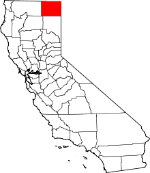
| County | Modoc County |
| Elevation[1] | 4,035 ft (1,230 m) |
Stronghold is an unincorporated community in Modoc County, California.[1] It is located on the Southern Pacific Railroad, 3 miles (4.8 km) northwest of Newell,[2] at an elevation of 4035 feet (1230 m).[1]
Stronghold is located near the Oregon border. The ZIP Code is 96134. The community is inside area code 530.
Its coordinates are 41°54′20″N 121°24′35″W / 41.90556°N 121.40972°W at 4,035 feet (1,230 m) elevation. The place was named for Captain Jack's Stronghold held by the Modoc in 1872 and 1873 during the Modoc War,[2] at the nearby Lava Beds National Monument.
Politics
In the state legislature, Stronghold is in the 1st Senate District, represented by Republican Dave Cox, and in the 2nd Assembly District, represented by Republican Jim Nielsen.
Federally, Stronghold is in California's 1st congressional district, represented by Republican Doug LaMalfa.[3]
References
- 1 2 3 U.S. Geological Survey Geographic Names Information System: Stronghold, California
- 1 2 Durham, David L. (1998). California's Geographic Names: A Gazetteer of Historic and Modern Names of the State. Clovis, Calif.: Word Dancer Press. p. 422. ISBN 1-884995-14-4.
- ↑ "California's 1st Congressional District - Representatives & District Map". Civic Impulse, LLC. Retrieved March 3, 2013.