Sycamore, Kansas
| Sycamore, Kansas | |
|---|---|
| Unincorporated community | |
 Sycamore, Kansas  Sycamore, Kansas Location within the state of Kansas | |
| Coordinates: 37°19′37″N 95°42′56″W / 37.32694°N 95.71556°WCoordinates: 37°19′37″N 95°42′56″W / 37.32694°N 95.71556°W | |
| Country | United States |
| State | Kansas |
| County | Montgomery |
| Time zone | Central (CST) (UTC-6) |
| • Summer (DST) | CDT (UTC-5) |
| ZIP codes | 67363 |

Sycamore (also Lay) is an unincorporated community in northern Montgomery County, Kansas, United States. It lies along U.S. Route 75 north of the city of Independence, the county seat of Montgomery County.[1] Its elevation is 843 feet (257 m), and it is located at 37°19′37″N 95°42′56″W / 37.32694°N 95.71556°W (37.3270085, -95.7155358).[2] Although it is unincorporated, it has a post office, with the ZIP code of 67363.[3]
History
Sycamore had its start by the building of the railroad through that territory.[4]
The post office, established as Lay in 1887, was renamed Sycamore in 1896.[5]
Climate
The climate in this area is characterized by hot, humid summers and generally mild to cool winters. According to the Köppen Climate Classification system, Sycamore has a humid subtropical climate, abbreviated "Cfa" on climate maps.[6]
References
- ↑ Rand McNally. The Road Atlas '08. Chicago: Rand McNally, 2008, p. 41.
- ↑ Geographic Names Information System Feature Detail Report, Geographic Names Information System, 1978-10-13. Accessed 2008-04-12.
- ↑ Zip Code Lookup
- ↑ Duncan, L. Wallace (1903). History of Montgomery County, Kansas. Press of Iola Register. p. 82.
- ↑ "Kansas Post Offices, 1828-1961". Kansas Historical Society. Retrieved 16 June 2014.
- ↑ Climate Summary for Sycamore, Kansas
Municipalities and communities of Montgomery County, Kansas, United States | ||
|---|---|---|
| Cities | 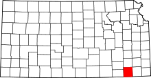 | |
| Unincorporated communities | ||