Coffeyville, Kansas
| Coffeyville, Kansas | |
|---|---|
| City | |
|
Sign at the entrance to the city (2006) | |
 Location within Montgomery County and Kansas | |
 KDOT map of Montgomery County (legend) | |
| Coordinates: 37°2′16″N 95°37′35″W / 37.03778°N 95.62639°WCoordinates: 37°2′16″N 95°37′35″W / 37.03778°N 95.62639°W[1] | |
| Country | United States |
| State | Kansas |
| County | Montgomery |
| Founded | 1869 |
| Incorporated | March 1873[2] |
| Government | |
| • Mayor | Jim Faulkner |
| Area[3] | |
| • Total | 7.43 sq mi (19.24 km2) |
| • Land | 7.43 sq mi (19.24 km2) |
| • Water | 0 sq mi (0 km2) |
| Elevation[1] | 738 ft (225 m) |
| Population (2010)[4] | |
| • Total | 10,295 |
| • Estimate (2013)[5] | 9,949 |
| • Density | 1,400/sq mi (540/km2) |
| • µSA | 34,292 |
| Time zone | CST (UTC-6) |
| • Summer (DST) | CDT (UTC-5) |
| ZIP code | 67337 |
| Area code | 620 |
| FIPS code | 20-14600 [1] |
| GNIS feature ID | 0469230 [1] |
| Website | coffeyville.com |

Coffeyville is a city in southeastern Montgomery County, Kansas, United States, located along the Verdigris River in the state's southeastern region.[1] As of the 2010 census, the city population was 10,295.[6] It is the most populous city of Montgomery County and with its southeast Kansas location is located in the Tulsa, Oklahoma media market. The town of South Coffeyville, Oklahoma is located approximately 1 mile south of the city, existing as a separate political entity immediately south of the state line.
History
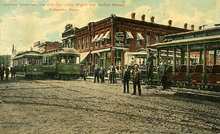
This settlement was founded in 1869 as an Indian trading post by Col. James A. Coffey, serving the population across the border in what was then the Indian Territory. The town was stimulated in 1871 by being made a stop on the Leavenworth, Lawrence & Galveston Railroad, which connected it to other markets and developments. With the arrival of the railroad, a young surveyor, Napoleon B. Blanton, was dispatched to lay out the town. The naming of the town was left to the toss of a coin between Col. Coffey and U.S. Army Captain Blanton. Coffey won the toss and the town was officially named Coffeyville.
The city was first incorporated in 1872, but the charter was voided as illegal, and the city was re-incorporated in March 1873.[2][7]
As a frontier settlement, Coffeyville had its share of violence. On October 5, 1892, four of the Dalton Gang were killed in a shootout during an attempted bank robbery; Emmett Dalton survived with 23 gunshot wounds and convicted at trial for his crimes. He served 14 years before being pardoned. The gang had been trying to rob the First National and Condon banks, located across the street from each other. Residents recognized them under their disguises of fake beards and attacked the gang members as they fled one of the banks. Four citizens, including a U.S. marshal, Marshal Charles T. Connelly, died defending the town. The town holds an annual celebration each October to commemorate the Dalton Raid and the citizens who were lost.
After the discovery of its resources of plentiful natural gas and abundant clay, Coffeyville enjoyed rapid growth from 1890 to 1910, as its population expanded sixfold. From the turn of the 20th century to the 1930s, it was one of the largest glass and brick manufacturing centers in the nation. During this same period, the development of oil production attracted the founding of several oil field equipment manufacturers, and more workers and residents.[7]
Coffeyville industrialist Douglas Brown founded Coffeyville Multiscope, which produced components of the Norden bombsight. This played a determining role in the perfection of precision daylight bombing during World War II as a result of the bombsight's advanced accuracy and drift correction capability.
In 1930 residents in Coffeyville organized a Church of Latter Day Saints (LDS) Sunday School; it was one of only 11 places in Kansas to have such a facility then.[8]
2007 flood
On July 1, 2007, Coffeyville suffered a major flood when the Verdigris River crested at 10 feet above flood stage and flooded approximately a third of the city. The flood topped the local refinery (Coffeyville Resources LLC) levees by 4 feet, allowing oil to pollute the water. Approximately 1700 barrels (71,000 gallons) of crude oil mingled with the already contaminated flood waters.[9] The EPA worked to prevent the oil and flood water mix from continuing downriver, where it could damage the water in Oologah Lake near Oologah, Oklahoma. Many residential water supplies are drawn from that lake. A minimal amount of oil reached Oolagah Lake, and it did not pose a threat to the water supplies of other cities along the Verdigris River or from the lake. A number of animals were found dead or injured in flood areas, covered with oil.
By July 2, areas east of Patterson Street were off limits, and a curfew was enacted in other areas of the city. On July 3, the city lost its supply of potable water, but the water service was restored and the order to boil water rescinded on July 7. The Federal Emergency Management Agency (FEMA) and the Red Cross came to aid residents, and Kansas Governor Kathleen Sebelius and President George W. Bush declared the city a federal disaster area. Most displaced residents found shelter with family and friends, but many were sheltered in two area churches and a senior citizens' apartment complex. Some pets were rescued to a temporary animal shelter built for them at LeClere Park.
The flooded area on the city's east side was reopened on July 11 for residents and business owners to begin assessing damage and to retrieve salvageable items.

In order to focus on the post-flood recovery and clean-up, the city and state cancelled the 2007 Inter-State Fair & Rodeo.[10] The ongoing flood recovery included a wholesale environmental remediation of the flood-affected eastern portion of the city, which continued through late 2008 to early 2009. Many of the flood-damaged homes were purchased by Coffeyville Resources LLC as a part of its effort to compensate the homeowners affected by the oil spill.[11]
Geography
Coffeyville is located in the southeast corner of Kansas, about 75 miles (121 km) north of Tulsa, Oklahoma, and 60 miles (97 km) west of Joplin, Missouri. The city is situated about one-half mile north of the Oklahoma state line at 37°2′16″N 95°37′35″W / 37.03778°N 95.62639°W (37.037708, -95.626438),[1] along the west bank of the Verdigris River. The city is the location of the lowest point in the state of Kansas at 679 feet (207 m) above sea level. Coffeyville Municipal Airport is a few miles northeast of the city along US-169. Though Coffeyville is the largest city in Montgomery County, the county seat is Independence, 16 miles (26 km) northwest of the city.
Coffeyville, specifically a spot just north of Coffeyville Country Club, is the default center starting point of Google Maps, being the accidental center point of the default starting map being displayed, which shows the 48 contiguous United States.[12] (Lawrence, Kansas also claims to be the Google center). Other locations that are considered to be the geographic center of the contiguous United States are also in Kansas.
According to the United States Census Bureau, the city has a total area of 7.43 square miles (19.24 km2), all land.[3]
Climate
| Climate data for Coffeyville, Kansas | |||||||||||||
|---|---|---|---|---|---|---|---|---|---|---|---|---|---|
| Month | Jan | Feb | Mar | Apr | May | Jun | Jul | Aug | Sep | Oct | Nov | Dec | Year |
| Record high °F (°C) | 74 (23) |
86 (30) |
90 (32) |
100 (38) |
95 (35) |
104 (40) |
116 (47) |
112 (44) |
108 (42) |
98 (37) |
86 (30) |
78 (26) |
116 (47) |
| Average high °F (°C) | 42 (6) |
48 (9) |
58 (14) |
68 (20) |
76 (24) |
85 (29) |
90 (32) |
91 (33) |
82 (28) |
70 (21) |
57 (14) |
45 (7) |
67.7 (19.8) |
| Average low °F (°C) | 20 (−7) |
25 (−4) |
34 (1) |
43 (6) |
55 (13) |
64 (18) |
68 (20) |
66 (19) |
57 (14) |
45 (7) |
34 (1) |
23 (−5) |
44.5 (6.9) |
| Record low °F (°C) | −20 (−29) |
−16 (−27) |
−6 (−21) |
14 (−10) |
28 (−2) |
40 (4) |
47 (8) |
45 (7) |
27 (−3) |
15 (−9) |
2 (−17) |
−18 (−28) |
−20 (−29) |
| Average precipitation inches (mm) | 1.65 (41.9) |
2.04 (51.8) |
3.47 (88.1) |
4.32 (109.7) |
6.60 (167.6) |
5.98 (151.9) |
3.83 (97.3) |
3.54 (89.9) |
4.87 (123.7) |
4.14 (105.2) |
2.98 (75.7) |
2.28 (57.9) |
45.7 (1,160.7) |
| Average snowfall inches (cm) | 7.7 (19.6) |
6 (15) |
3.8 (9.7) |
1 (3) |
0 (0) |
0 (0) |
0 (0) |
0 (0) |
0 (0) |
0.1 (0.3) |
1.6 (4.1) |
6 (15) |
26.2 (66.7) |
| Source: http://www.weather.com/weather/wxclimatology/monthly/graph/USKS0119 | |||||||||||||
Demographics
| Historical population | |||
|---|---|---|---|
| Census | Pop. | %± | |
| 1880 | 753 | — | |
| 1890 | 2,282 | 203.1% | |
| 1900 | 4,953 | 117.0% | |
| 1910 | 12,687 | 156.1% | |
| 1920 | 13,452 | 6.0% | |
| 1930 | 16,198 | 20.4% | |
| 1940 | 17,355 | 7.1% | |
| 1950 | 17,113 | −1.4% | |
| 1960 | 17,382 | 1.6% | |
| 1970 | 15,116 | −13.0% | |
| 1980 | 15,185 | 0.5% | |
| 1990 | 12,917 | −14.9% | |
| 2000 | 11,021 | −14.7% | |
| 2010 | 10,295 | −6.6% | |
| Est. 2015 | 9,669 | [13] | −6.1% |
| U.S. Decennial Census[14] | |||
Coffeyville has experienced a slow and steady population decline since around 1960, when its population peaked at more than 17,000. Changes in industry and oil production have caused a loss of jobs in the area, and residents have moved to find work. As of 2006 the population was estimated to be 10,387 in the year 2006, a decrease of 645, or -5.8%, over the previous six years.[15]
2010 census
As of the census[4] of 2010, there were 10,295 people, 4,226 households, and 2,456 families residing in the city. The population density was 1,385.6 inhabitants per square mile (535.0/km2). There were 5,021 housing units at an average density of 675.8 per square mile (260.9/km2). The racial makeup of the city was 72.3% White, 11.7% African American, 5.0% Native American, 0.7% Asian, 0.2% Pacific Islander, 3.3% from other races, and 6.8% from two or more races. Hispanic or Latino of any race were 7.4% of the population.
There were 4,226 households of which 28.2% had children under the age of 18 living with them, 39.9% were married couples living together, 13.5% had a female householder with no husband present, 4.8% had a male householder with no wife present, and 41.9% were non-families. 35.7% of all households were made up of individuals and 16.1% had someone living alone who was 65 years of age or older. The average household size was 2.29 and the average family size was 2.98.
The median age in the city was 37.1 years. 22.6% of residents were under the age of 18; 13.3% were between the ages of 18 and 24; 22.4% were from 25 to 44; 23.6% were from 45 to 64; and 18.1% were 65 years of age or older. The gender makeup of the city was 47.5% male and 52.5% female.
2000 census
As of the U.S. Census in 2000,[16] there were 11,021 people, 4,691 households, and 2,847 families residing in the city. The population density was 1,562.1 people per square mile (602.7/km²). There were 5,550 housing units at an average density of 786.6 per square mile (303.5/km²). The racial makeup of the city was 75.76% White, 12.12% Black or African American, 4.97% Native American, 0.60% Asian, 0.04% Pacific Islander, 1.63% from other races, and 4.87% from two or more races. Hispanic or Latino of any race were 3.82% of the population.
There were 4,691 households out of which 26.8% had children under the age of 18 living with them, 45.0% were married couples living together, 11.9% had a female householder with no husband present, and 39.3% were non-families. 35.4% of all households were made up of individuals and 18.6% had someone living alone who was 65 years of age or older. The average household size was 2.25 and the average family size was 2.90.
In the city the population was spread out with 24.0% under the age of 18, 10.0% from 18 to 24, 23.3% from 25 to 44, 21.3% from 45 to 64, and 21.4% who were 65 years of age or older. The median age was 39 years. For every 100 females there were 87.2 males. For every 100 females age 18 and over, there were 82.1 males.
The median income for a household in the city was $25,542, and the median income for a family was $33,180. Males had a median income of $29,199 versus $17,940 for females. The per capita income for the city was $15,182. About 10.9% of families and 15.0% of the population were below the poverty line, including 18.6% of those under age 18 and 10.9% of those age 65 or over.
Economy
Coffeyville has a long history as a center of industry and manufacturing. Coffeyville Resources operates a 100,000 barrels per day refinery and a large nitrogen fertilizer plant, using a unique Texaco process of ammonia extraction from coke byproducts produced in the refinery. Sherwin Williams Chemical Co. has operated a chemical plant in the community since 1909.
Coffeyville is also home to John Deere Corporation's Coffeyville Works, which is a major manufacturer of off-road equipment automatic transmissions for the construction, agriculture and mining industries. Acme Foundry is a foundry that has been in operation since 1905 and employs more than 300 people.[17]
Taylor Crane & Rigging is a regional hauling operation, full-service industrial mover and craning services company. Taylor also maintains a facility in Tulsa, Oklahoma[18] Other nearby in-county employers include Cessna Aircraft Division of Textron and Spears Manufacturing, a large producer of extruded PVC pipe products.
- Historic
Southwire Corp is a maker of stranded and solid core wire and acquired the Leviton Industries facility of American Insulated Wire in 2010. The plant was closed in 2014.
Coffeyville is home to a fulfillment center leased since 1999 by online retailer Amazon.com.[19] It was opened in a facility previously operated by Golden Books. After more than a decade of operations here, Amazon announced that it would close this warehouse in February 2015, because it was shifting to warehouses located closer to large cities.[20][21]
Education
- Public
Public education is provided by the Coffeyville School District (USD 445). The district educates almost 2,000 students in three facilities.[22] The district has one early learning center, one large consolidated elementary school with four pods and an Age-to-Age kindergarten, one middle school and one high school.
- Field Kindley High School, grades 9–12, named after Field Kindley.[23]
- Roosevelt Middle School, grades 7–8.
- Community Elementary School, grades K–6. Age-to-Age Kindergarten
Five-year-old kindergarten children spend their days learning beside community members who have 80, 90, and even 100 years of life skills and experiences. Now, as we end our seventh year of intergenerational learning, it is evident that both age groups benefit from what the other generation has to offer. The needs of the elderly are met through reasons most people understand: the children offer them purpose and fill their days with energy and productive activities. The children’s needs are met at a different but equal level. The grandmas and grandpas have time to listen to their stories about family and pets and about what makes them happy and what scares them.
Age-to-Age Kindergarten offers a unique experience for students on a daily basis. Age-to-Age days are spent with intergenerational exercise, small group table times, individual sign-in times with a grandma, one-on-one reading, and regular social studies and science experiences. This is in partnership with Windsor Place.
- Dr. Jerry Hamm Early Learning Center, grades preschool. The educational opportunities provided by the teachers and staff at the early learning center are designed to allow young children experiences to increase their social and emotional skills as well as their cognitive, literacy and numeracy skills. The children who attend the ELC are entering the kindergarten classroom better prepared to thrive in the classroom environment. The goal is to create a foundation which will impact students’ learning for a lifetime. This is in partnership with Kansas Head Start Association.
- Private
- Holy Name School, grades PK-6, parochial private school operated by the Roman Catholic Church.
- College
Advanced education is provided by Coffeyville Community College at three campuses. The main campus and technical trades campus are each located in Coffeyville, while a third campus is located in Columbus, Kansas. Four-year college degrees are offered by Oklahoma Wesleyan University, Friends University and Sterling College at the main Coffeyville Community College campus.[24] Coffeyville Community College has a long history of academic and athletic success.
Transportation
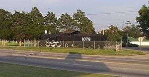
Bus service is provided northward towards Kansas City, Missouri and southward towards Tulsa, Oklahoma by Jefferson Lines (subcontractor of Greyhound Lines).[25][26] Coffeyville and surrounding communities are also served by Connections Transportation which has its headquarters in nearby Independence, Kansas. Coffeyville has two railroads that serve the community, Union Pacific and a short line railroad SKO and WATCO. Coffeyville is served by two US highways, US 166 which runs east-west from where the highway enters from the east at the Verdigris River bridge on Northeast Street to Eleventh Street, and exits to the west at the Union Pacific Railroad viaduct on Eighth Street. US 169 which is a north-south highway, enters from the east at the Verdigris River bridge on Northeast Street to Eleventh Street, then turns left just past the SKO-WATCO railroad overpass onto Walnut Street and continues south on Walnut Street and exits the city and continues south towards Tulsa, Oklahoma.
Media
The Coffeyville Journal is the local newspaper, published twice a week.[27]
One AM and three FM radio stations are licensed to and/or broadcast from Coffeyville. KGGF (AM) broadcasts on 690 AM, playing a News/Talk format.[28] KUSN, a Country station, is licensed to Dearing, Kansas, but broadcasts from Coffeyville on 98.1 FM. KGGF-FM, licensed to Fredonia, Kansas, broadcasts an Oldies format from Coffeyville on 104.1 FM.[28][29] KQQF is licensed to Coffeyville and broadcasts on 98.9 FM.[28]
Coffeyville is in the Tulsa, Oklahoma television market.[30]
In popular culture
- Coffeyville is mentioned in the song "Doolin–Dalton" by The Eagles from their 1973 album, Desperado.
- In the 2002 movie, Reign of Fire character Denton Van Zan (Matthew McConaughey) refers to Coffeyville when describing his moment of realizing how to kill dragons in the movie.
- Coffeyville is a featured location in the 2009 video game Call of Juarez : Bound in Blood, and its successor Call of Juarez: Gunslinger.
Notable people
Notable individuals who were born in and/or have lived in Coffeyville include:
- Mildred "Micky" Axton, aviator and educator
- Terry Beeson, NFL lineman, Seattle Seahawks
- Bob Bettisworth, member of the Alaska House of Representatives
- Mildred Burke, member of the Professional Wrestling Hall of Fame
- Phil Ehart, drummer of the rock band "Kansas"
- Mondriel Fulcher, NFL player
- Denver David Hargis, Kansas politician
- Kenyon Hopkins, musician and composer
- Walter Johnson, Hall of Fame baseball player
- Ron Kenoly, popular worship leader
- Field Eugene Kindley, aviator and World War I ace
- Jack "Dusty" Kleiss, World War II naval aviator and Navy Cross recipient[31]
- Omar Knedlik, inventor of the ICEE frozen drink
- Rudy May, former Major League baseball pitcher
- William Mueller, professional wrestler known under the names, "Trevor Murdoch" and "Jethro Holiday"
- Gary S. Paxton, American record producer of 1962 novelty song "Monster Mash"
- Lafayette "Reb" Russell, football player and western movie actor
- Johnny Rutherford, race car driver
- Henry Schichtle, football player
- Cynthia Sikes, actress
- Ralph "Tut" Tuttle, World War II Army Air Corps pilot in the Pacific Theater, flying more than 250 missions, earning two Distinguished Flying Crosses and a Silver Star, brother of Micky Axton (see above)[32]
- Frank Wickware, Negro Leagues and Pre-Negro Leagues baseball pitcher
- Wendell Willkie, 1940 Republican presidential candidate
See also
References
- Notes
- 1 2 3 4 5 6 Geographic Names Information System (GNIS) details for Coffeyville, Kansas; United States Geological Survey (USGS); October 13, 1978.
- 1 2 "Coffeyville History". City of Coffeyville. Retrieved 2006-07-16.
Coffeyville was incorporated in March, 1872, but the corporation was found to be illegal and it was again incorporated in March, 1873.
- 1 2 "US Gazetteer files 2010". United States Census Bureau. Archived from the original on 2012-01-24. Retrieved 2012-07-06.
- 1 2 "American FactFinder". United States Census Bureau. Retrieved 2012-07-06.
- ↑ "Population Estimates". United States Census Bureau. Retrieved 2014-11-29.
- ↑ "2010 City Population and Housing Occupancy Status". U.S. Census Bureau. Archived from the original on July 21, 2011. Retrieved March 6, 2011.
- 1 2 Federal Writers' Project (1939). Kansas: A Guide to the Sunflower State. Works Progress Administration. p. 174.
- ↑ Jenson, Andrew. Encyclopedic History of the Church of Jesus Christ of Latter-day Saints (Salt Lake City:Deseret Book, 1941) p. 391-392
- ↑ "Brownback, Roberts view flooded areas in Kansas". Kansas City. Retrieved 2007-07-06.
- ↑ "Fair Association Press Release". CoffeyvilleFlood.Com. Retrieved 2007-07-07.
- ↑ "Coffeyville resilient after refinery flood"; The Wichita Eagle; 25 September 2011
- ↑ Cadenhead, Rogers (2006-02-22). "All Google's Roads Lead to Kansas". Wired. Retrieved 2009-09-03.
- ↑ "Annual Estimates of the Resident Population for Incorporated Places: April 1, 2010 to July 1, 2015". Retrieved July 2, 2016.
- ↑ United States Census Bureau. "Census of Population and Housing". Archived from the original on May 11, 2015. Retrieved November 29, 2014.
- ↑ "Population Estimates". U.S. Census Bureau, Population Division. Annual estimates of the population to 2006-07-01. Released 2007-06-28. Population change is from 2000-07-01 to 2006-07-01.
- ↑ "American FactFinder". United States Census Bureau. Archived from the original on 2013-09-11. Retrieved 2008-01-31.
- ↑ http://www.acmefoundry.net/aboutus/
- ↑ http://www.taylorcrane.com/
- ↑ "Inside Amazon.com's Coffeyville Warehouse", Technomadia; Dec 2009
- ↑ Amazon to close Coffeyville warehouse; The Wichita Eagle; 1 October 2014.
- ↑ "Amazon closing distribution plant in Kansas", WSB-TV; 1 October 2014
- ↑ "Coffeyville schools". GreatSchools.net. Retrieved 2006-07-16.
- ↑ Year Books.
- ↑ http://www.ccc.cc.ks.us/academics/university_outreach.htm
- ↑ Jefferson Lines
- ↑ Greyhound Lines - Bus stops in Kansas
- ↑ "Record Details - Coffeyville Journal". Kansas Press Association. Retrieved 2013-08-15.
- 1 2 3 "Radio Stations in Coffeyville, Kansas". Radio-Locator. Retrieved 2013-08-15.
- ↑ "Radio Results Group". Radio Results Group. Retrieved 2013-08-15.
- ↑ "TV Market Maps - Tulsa, Oklahoma". EchoStar Knowledge Base. Retrieved 2013-08-15.
- ↑ Orr, Timothy, PhD, and Laura Orr, pp 8–11
- ↑ "Micky Axton". Eden Prairie News -. October 29, 2008. Retrieved 2013-02-27.
- Sources
- Orr, Timothy, PhD and Laura Orr. "Jack "Dusty" Kleiss and the Battle of Midway" (PDF). The Daybook, Volume 15, Issue 4. Hampton Roads Naval Museum (HRNM), Department of the Navy. Retrieved 9 February 2013.
Further reading
- Cadenhead, Rogers (2006-02-22). "All Google's Roads Lead to Kansas". Wired News. Retrieved 2006-07-16. Kristine Crispel's horse farm outside Coffeyville has the distinction of being the center of the world—according to Google.
- History of the State of Kansas; William G. Cutler; A.T. Andreas Publisher; 1883. (Online HTML eBook)
- Kansas : A Cyclopedia of State History, Embracing Events, Institutions, Industries, Counties, Cities, Towns, Prominent Persons, Etc; 3 Volumes; Frank W. Blackmar; Standard Publishing Co; 944 / 955 / 824 pages; 1912. (Volume1 - Download 54MB PDF eBook),(Volume2 - Download 53MB PDF eBook), (Volume3 - Download 33MB PDF eBook)
External links
| Wikimedia Commons has media related to Coffeyville, Kansas. |
- City
- Schools
- USD 445, local school district
- Historical
- Maps
- Coffeyville City Map, KDOT
Municipalities and communities of Montgomery County, Kansas, United States | ||
|---|---|---|
| Cities | 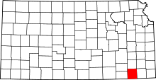 | |
| Unincorporated communities | ||