T'uruchipa River
| T'uruchipa | |
| River | |
| Name origin: Quechua | |
| Country | Bolivia |
|---|---|
| Region | Potosí Department |
| Municipality | José María Linares Province |
| Tributaries | |
| - left | Q'inqu |
| - right | Anawayu |
| Coordinates | BO 19°31′S 64°52′W / 19.517°S 64.867°WCoordinates: BO 19°31′S 64°52′W / 19.517°S 64.867°W |
| Mouth | Pillku Mayu |
| - location | T'uruchipa Canton |
T'uruchipa (Quechua t'uru mud, chipa trap,[1] hispanicized spelling Turuchipa) is a Bolivian river in the Potosí Department, José María Linares Province, Ckochas Municipality, T'uruchipa Canton.[2] It is a right tributary to the Pillku Mayu.[3]
Upstream in the Nor Cinti Province, San Lucas Municipality, the river is called San Lucas. The direction is mainly north east as it flows along the town San Lucas, Uruchini and T'uruchipa until reaching the Pillku Mayu between the villages Urunkuta and Ruphasqa.
See also
References
- ↑ Teofilo Laime Ajacopa, Diccionario Bilingüe, Iskay simipi yuyayk'ancha, Quechua – Castellano, Castellano – Quechua (Quechua - Spanish dictionary)
- ↑ Puna Municipality (still including the recently created Ckochas Municipality): population data and map
- ↑ Jorge Molina Carpio, Daniel Espinoza Romero, Balance hídrico superficial de la cuenca alta del río Pilcomayo, La Paz 2005 (Spanish)
Capital: Potosí | ||
| Provinces | 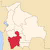 | |
| Municipalities (and seats) |
| |
This article is issued from Wikipedia - version of the 4/4/2016. The text is available under the Creative Commons Attribution/Share Alike but additional terms may apply for the media files.