Tapulikaupunki
| Tapulikaupunki Stapelstaden | |
|---|---|
| Helsinki Subdivision | |
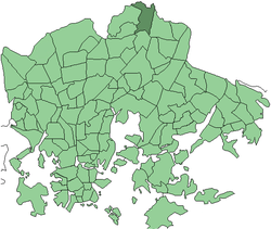 Position of Tapulikaupunki within Helsinki | |
| Country |
|
| Region | Uusimaa |
| Sub-region | Greater Helsinki |
| Municipality | Helsinki |
| Subdivision number | 402 |
| District | Northeastern |
| Area | 2,20 km2 (80 sq mi) |
| Population (1 January 2005) | 8,582 |
| • Density | 3,901/km2 (10,100/sq mi) |
| Postal codes | 00730, 00740, 00750 |
| Neighbouring subdivisions | Puistola, Tapaninkylä, Töyrynummi, Siltamäki, Tapanila |
Tapulikaupunki (Finnish), Stapelstaden (Swedish) is a northern neighborhood of Helsinki, Finland.
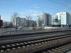
Tapulikaupunki is located on Main Line next to Puistola station. Subarea Puistola in the district Suursuo located on the opposite side of the railroad. Lower Tikkurila is a subarea of Tapulikaupunki.
Tapulikaupunki is built on the land that belonged to an agricultural research station that was on the field from 1925 to 1960 century. When operations ceased began planning what to do with the muddy fields. A high-rise district was born in the 1970s and was scheduled high and tight. It was square concrete houses. New innovation was the designated car parking separate from the houses so that you could create pedestrian areas.
The area was first called high-rise area of Puistola station, but residents quickly began calling area Tapulikaupunki, according to road named Tapulikaupungintie which went through the district. In the 1970s the name Tapulikaupunki became official.
Most of the buildings are from the 1970s and early 1980s. In the 1990s, built a new townhouse and apartment block area and in the 2000s they built modern high-rises along the railway.
The first residents are getting old and the number of children has decreased. A day care centers have already been demolished to give way to high-rise. Another day care centers have closed. Many residents feel unsafe around the station, where there are many of the city's rental housing where you placed the drug addicts and people with mental health problems. In practice, the area is still safe.

Coordinates: 60°16′30″N 25°02′00″E / 60.27500°N 25.03333°E