Tar Hill, Kentucky
| Tar Hill | |
|---|---|
| Unincorporated community | |
 Tar Hill Tar Hill's position in Kentucky. | |
| Coordinates: 37°33′56″N 86°13′06″W / 37.56556°N 86.21833°WCoordinates: 37°33′56″N 86°13′06″W / 37.56556°N 86.21833°W | |
| Country |
|
| State |
|
| County | Grayson |
| Named after the Federal Asphalt Mine nearby. The mine and store closed in 1928. | The "Tar Hill store" re-opened in 1928 by the Tulley family in its present location. |
| Elevation | 219 m (718 ft) |
| Time zone | Central (CST) (UTC-6) |
| • Summer (DST) | CDT (UTC-5) |
| GNIS feature ID | 509187 |
| U.S. Geological Survey Geographic Names Information System: Tar Hill, Kentucky | |
Tar Hill is an unincorporated community in Grayson County, Kentucky, United States.[1] On April 26, 2011, two tornadoes hit Tar Hill as part of the 2011 Super Outbreak.[2] The first tornado was rated as an EF2, was 440 yards (400 m) wide and traversed a path of 3 miles (4.8 km), snapping and uprooting numerous large hardwood trees, destroying a travel trailer, a mobile home, numerous outbuildings and barns, and that fifteen homes had major roof damage.[3] Farm equipment was reportedly thrown 50 yards (46 m).[3] Other reports stated that this tornado destroyed a house, a mobile home, several barns and other buildings.[4] The second tornado was rated as an EF0, was 60 yards (55 m) wide and travelled a path 0.28 miles (450 m), snapping and uprooting trees.[2][3]
References
- ↑ "Feature Detail Report for: Tar Hill, Kentucky." USGS. U.S. Geological Survey Geographic Names Information System: Tar Hill, Kentucky Retrieved May 2, 2011.
- 1 2 NOAA Report
- 1 2 3 NWS-Louisville Report
- ↑ http://www.courierpress.com/news/2011/apr/27/possible-tornado-damage-reported-two-kentucky-coun/?partner=RSS Courier Press Report
Municipalities and communities of Grayson County, Kentucky, United States | ||
|---|---|---|
| Cities | 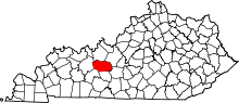 | |
| CDP | ||
| Other unincorporated communities | ||