Tayum, Abra
| Tayum | |
|---|---|
| Municipality | |
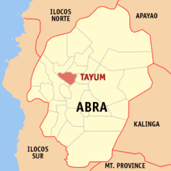 Location within Abra province | |
.svg.png) Tayum Location within the Philippines | |
| Coordinates: 17°37′N 120°40′E / 17.62°N 120.66°ECoordinates: 17°37′N 120°40′E / 17.62°N 120.66°E | |
| Country | Philippines |
| Region | Cordillera Administrative Region (CAR) |
| Province | Abra |
| District | Lone District of Abra |
| Barangays | 11 (see Barangays) |
| Government [1] | |
| • Type | Sangguniang Bayan |
| • Mayor | Felix Joash Eduarte[2] |
| Area[3] | |
| • Total | 61.14 km2 (23.61 sq mi) |
| Population (2015 census)[4] | |
| • Total | 14,467 |
| • Density | 240/km2 (610/sq mi) |
| • Voter (2016)[5] | 9,285 |
| Time zone | PST (UTC+8) |
| ZIP code | 2803 |
| IDD : area code | +63 (0)74 |
| Income class | 5th class |
| PSGC | 140124000 |
Tayum, officially the Municipality of Tayum (Ilocano: Ili ti Tayum, Filipino: Bayan ng Tayum), is a municipality in the province of Abra in the Cordillera Administrative Region (CAR) of the Philippines. The population was 14,467 at the 2015 census.[4] In the 2016 election, it had 9,285 registered voters.[5]
Tayum is just 7 kilometres (4.3 mi) east of capital Bangued. Roman Catholicism is the dominant religion. Every 25 November, Tayum celebrates its town fiesta.
History
Records show that Tayum got its name after the indigo plant which was commonly known to the Ilocanos as Tayum-Tayum. There was a time when indigo flourished in Tayum, then a source of wealth to the Ilocanos. In Barangay Deet, half kilometer away from the town proper, there was a big vat (Pagtimbugan) used in decaying the plant into a blue-black dye called ngila. The dye was used to color yams of cotton. At the beginning of the century, however, a powder dye from the Aniline Factories of Germany came into popular use among Ilocano weavers, causing the death of the indigo industry.
The earliest historical accounts of Tayum date back to 1626 when one adventurous priest, Father Juan Pareja, organized Tayum, also known as Bukaw. Sometime in 1569, an Augustinian Priest, Father Gabriel Alvarez, constructed a temporary chapel in Tayum during the time of his expedition to Lepanto. It was however in 1725 when Tayum was formally organized as a political unit under the Spanish Regime. Don Vidal Banganan served as the first Gobernadorcillo.
From a mere visita of Bangued, Tayum transformed into an independent mission in 1807 with the construction of the solid brick-walled church under the successive Augustinian missions. The church was dedicated to St. Catherine of Alexandria whose feastday is celebrated every 25th day of November. In 1904, Tayum reverted to a barrio of Bangued, due to the deterioration of peace and order at the time. Tayum ended as a barrio on December 31, 1907, with the designation of Don Pio Balmaceda y Belmonte as Teniente del barrio. Balmaceda organized his men in effectively curbing lawlessness thus restoring the town’s peacefulness. Shortly afterwards, it regained its town status with Don Manuel Brillantes as it first president.
Geography
Tayum is located at 17°37′N 120°40′E / 17.62°N 120.66°E.
According to the Philippine Statistics Authority, the municipality has a land area of 61.14 square kilometres (23.61 sq mi)[3] constituting 1.47% of the 4,165.25-square-kilometre- (1,608.21 sq mi) total area of Abra.
Barangays
Tayum is politically subdivided into 11 barangays.[6]
| PSGC | Barangay | Population | ±% p.a. | ||
|---|---|---|---|---|---|
| 2015[4] | 2010[7] | ||||
| 140124001 | Bagalay | 6.8% | 987 | 937 | +0.99% |
| 140124002 | Basbasa | 6.2% | 892 | 849 | +0.95% |
| 140124003 | Budac | 8.8% | 1,268 | 1,286 | −0.27% |
| 140124004 | Bumagcat | 5.3% | 764 | 794 | −0.73% |
| 140124005 | Cabaroan | 8.7% | 1,263 | 1,251 | +0.18% |
| 140124006 | Deet | 6.4% | 929 | 912 | +0.35% |
| 140124007 | Gaddani | 10.1% | 1,455 | 1,325 | +1.80% |
| 140124008 | Patucannay | 10.5% | 1,521 | 1,317 | +2.78% |
| 140124009 | Pias | 8.3% | 1,205 | 1,165 | +0.64% |
| 140124010 | Poblacion | 18.5% | 2,672 | 2,645 | +0.19% |
| 140124011 | Velasco | 10.4% | 1,511 | 1,459 | +0.67% |
| Total | 14,467 | 13,940 | +0.71% | ||
Demographics
| Population census of Tayum | |||||||||||||||||||||||||
|---|---|---|---|---|---|---|---|---|---|---|---|---|---|---|---|---|---|---|---|---|---|---|---|---|---|
|
| ||||||||||||||||||||||||
| Source: PSA[4][7][8] | |||||||||||||||||||||||||
In the 2015 census, Tayum had a population of 14,467.[4] The population density was 240 inhabitants per square kilometre (620/sq mi).
In the 2016 election, it had 9,285 registered voters.[5]
List of Cultural Properties of Tayum
| Cultural Property wmph identifier |
Site name | Description | Province | City/Municipality | Address/Location | Coordinates | Image |
|---|---|---|---|---|---|---|---|
| Saint Catherine of Alexandria Church | A 19th-century Baroque church, declared a National Cultural Treasure by the National Museum of the Philippines in 2001.[9] | Abra | Tayum | 17°37′07″N 120°39′16″E / 17.618511°N 120.654319°ESaint Catherine of Alexandria Church) |  | ||
| First SVD Regional House | Established by Fr. Luis Beckert in 1912. Fr. Beckert is the first regional superior of the SVD Missionaries in Abra. | Abra | Tayum | 17°37′07″N 120°39′16″E / 17.618511°N 120.654319°E |  | ||
| Flores Ancestral House | Built in 1890. | Abra | Tayum | Isidro Flores St. | 17°37′04″N 120°39′18″E / 17.617696°N 120.655003°E | .JPG) | |
| Jose Cariño Sr. Ancestral House | Abra | Tayum | 1 Brilliantes corner Jose Cariño | 17°37′00″N 120°39′17″E / 17.616621°N 120.654817°E | 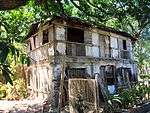 | ||
| Teodoro Brillantes Ancestral House | Abra | Tayum | Poblacion |  |
Transportation
The main mode of public transportation are tricycles and jeepneys.
See also
References
- ↑ "Municipality". Quezon City, Philippines: Department of the Interior and Local Government. Retrieved 31 May 2013.
- ↑ http://ph.rappler.com/local/region/Cordillera-Administrative-Region/Abra/Tayum
- 1 2 "Province: Abra". PSGC Interactive. Makati City, Philippines: Philippine Statistics Authority. Retrieved 28 October 2016.
- 1 2 3 4 5 "CORDILLERA ADMINISTRATIVE REGION (CAR)". Census of Population (2015): Total Population by Province, City, Municipality and Barangay (Report). PSA. Retrieved 20 June 2016.
- 1 2 3 "2016 National and Local Elections Statistics". Commission on Elections. 2016.
- ↑ "Municipal: Tayum, Abra". PSGC Interactive. Quezon City, Philippines: Philippine Statistics Authority. Retrieved 8 January 2016.
- 1 2 "CORDILLERA ADMINISTRATIVE REGION (CAR)". Census of Population and Housing (2010): Total Population by Province, City, Municipality and Barangay (Report). NSO. Retrieved 29 June 2016.
- ↑ "CORDILLERA ADMINISTRATIVE REGION (CAR)". Census of Population (1995, 2000 and 2007): Total Population by Province, City and Municipality (Report). NSO. Archived from the original on 24 June 2011.
- ↑ Alba, Reinerio. "The Restoration of 26 Philippine Churches". National Commission on Culture and the Arts. Retrieved 29 December 2014.
External links
| Wikimedia Commons has media related to Tayum, Abra. |
 |
La Paz | |
Dolores | |
| |
Lagangilang | |||
| ||||
| | ||||
| Bangued | |
Bucay |
Bangued (capital) | |
| Municipalities | |
| Barangays | |