Tenryū-Okumikawa Quasi-National Park
| Tenryū-Okumikawa Quasi-National Park | |
|---|---|
| 天竜奥三河国定公園 | |
|
IUCN category V (protected landscape/seascape) | |
|
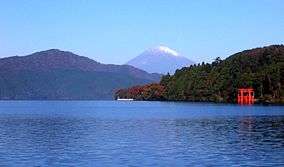
Tenryū River gorge, Nagano | |
 Tenryū-Okumikawa Quasi-National Park in Japan | |
| Location | Honshū, Japan |
| Coordinates | 35°16′N 137°50′E / 35.267°N 137.833°ECoordinates: 35°16′N 137°50′E / 35.267°N 137.833°E |
| Area | 25,756 ha |
| Established | October 1, 1969 |
| Governing body | Aichi, Nagano and Shizuoka prefectural governments [1] |

Tenryū-Okumikawa Quasi-National Park (天竜奥三河国定公園 Tenryū-Okumikawa Kokutei Kōen) is a quasi-national park in the Tokai region of Honshū in Japan. It is rated a protected landscape (category V) according to the IUCN.[2] The park includes the gorges of the upper Tenryū River, Sakuma Dam and its surrounding forests, Atera Seven Falls, Chausu Mountains and Mount Horaiji. It straddles the border between Shizuoka, Aichi and Nagano Prefectures.[3] The area was designated a quasi-national park on October 1, 1969.
Like all Quasi-National Parks in Japan, the park is managed by the local prefectural governments.[1]
See also
References
- Southerland, Mary and Britton, Dorothy. The National Parks of Japan. Kodansha International (1995). ISBN 4-7700-1971-8
- 1 2 "National Park systems: Definition of National Parks". National Parks of Japan. Ministry of the Environment of the Government of Japan. Retrieved 2008-08-29.
- ↑ "Teryu-Okumikawa". World Database on Protected Areas. United Nations Environment Programme, World Conservation Monitoring Center. Retrieved 2009-07-05.
- ↑ "List of Quasi-national Parks". Official Home Page of the Ministry of the Environment. Ministry of the Environment Government of Japan. 1994-03-31. Retrieved 2009-07-05.
This article is issued from Wikipedia - version of the 11/19/2016. The text is available under the Creative Commons Attribution/Share Alike but additional terms may apply for the media files.