Sanriku Fukkō National Park
| Sanriku Fukkō National Park | |
|---|---|
| 三陸復興国立公園 | |
|
IUCN category II (national park) | |
|
| |
| Location | Tōhoku, Japan |
| Area | 146.35 km2 |
| Established | 24 May 2013[2] |
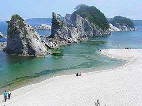
Sanriku Fukkō National Park (三陸復興国立公園 Sanriku Fukkō Kokuritsu Kōen) (lit. "Sanriku Reconstruction National Park") is a national park extending along the Sanriku Coast of Japan from Hachinohe in Aomori Prefecture through Iwate Prefecture to Kesennuma in Miyagi Prefecture. Created in 2013 in the aftermath of the 2011 Tōhoku earthquake and tsunami, it incorporates the former Rikuchū Kaigan National Park and Tanesashi Kaigan Hashikamidake Prefectural Natural Park. In 2014 the Ministry of the Environment plans to extend the park to include Minami Sanriku Kinkasan Quasi-National Park. Subsequently the park will be extended to include Kesennuma Prefectural Natural Park, Kenjōsan Mangokuura Prefectural Natural Park, and Matsushima Prefectural Natural Park.[2][3][4]
See also
| Wikimedia Commons has media related to Sanriku-Fukko National Park. |
References
- ↑ 浄土ヶ浜 [Jōdogahama] (in Japanese). Agency for Cultural Affairs. Retrieved 22 October 2013.
- 1 2 基礎情報 [Basic Information] (in Japanese). Ministry of the Environment. Retrieved 22 October 2013.
- ↑ "National park of restoration". The Japan Times. 28 May 2013. Retrieved 22 October 2013.
- ↑ Katsuragawa Hiroki. "Green reconstruction through the creating a new Sanriku Fukko (reconstruction) National Park" (PDF). IUCN. Retrieved 22 October 2013.
External links
Coordinates: 39°38′N 141°58′E / 39.633°N 141.967°E