The Towans

Towan (from Cornish: Tewyn,[1] meaning "sand dune") is found in many placenames in Cornwall (Porthtowan for example).[2] However, The Towans usually refers to the three-mile (5 km) stretch of coastal dunes which extends north-east from the estuary of the River Hayle (at 50°11′33″N 5°25′52″W / 50.19256°N 5.43111°W) to Gwithian beach (at 50°13′48″N 5°23′29″W / 50.22991°N 5.39145°W) with a midpoint near Upton (at 50°12′38″N 5°24′28″W / 50.21053°N 5.40768°WCoordinates: 50°12′38″N 5°24′28″W / 50.21053°N 5.40768°W).[3]
Although 'The Towans' refers to the whole stretch, individual areas of the dunes have their own identities. Those named by Ordnance Survey on its mapping are (from southwest to northeast) Lelant Towans, Hayle Towans, Riviere Towans, Mexico Towans, Common Towans, Phillack Towans, Upton Towans and Gwithian Towans.[4]
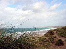
The Towans are bounded to the south-east by Phillack village and the B3301 Hayle to Portreath road; to the north-west, the dunes face St Ives Bay across an intertidal beach. Substantial areas of The Towans rise more than 50 metres (160 ft) above sea level, the highest point being 72 metres (236 ft) at Phillack Towans.[4] The southern half of The Towans is in Hayle civil parish and the northern half in Gwinear-Gwithian civil parish.[5] The southern half was in Phillack parish until 1935 when Phillack was absorbed in to the parish of Hayle.[6]
Gwithian to Mexico Towans SSSI
Much of the area falls within the Gwithian to Mexico Towans SSSI (Site of Special Scientific Interest), noted for both its geological and biological interest.[7][8] Two areas of the site are also Local Nature Reserves. Upton Towans is owned by the Cornwall Wildlife Trust. It is a habitat of sand dune and grassland is suited to a variety of wildlife and plants including the pyramidal orchid, glow worm, silver-studded blue butterfly, and skylark.[9][10][11] Species in Gwithian Towans Local Nature Reserve include skylarks and adders.[12][13]
Archaeology
Gwithian Towans cover the site of a Bronze Age farm which has been excavated although no remains are visible.
History
Upton Town was previously known as Great Towan, which contained an arable farm known as Upton Barton, and included a large area of towan grazing. At an uncertain date, sometime after 1650 the farmhouse was buried overnight with sand, following the frontal collapse of a high sand dune; the occupants escaped through the upper windows. The remains have not been since the winter of 1808–09. The evidence for Upton Barton was lost with the bombing of the Ordnance Survey, in Southampton during World War II.[14]
In 1879 the Reverend F Hockin, rector of Phillack, enclosed approximately 9 acres for tillage giving employment to a large number unemployed men. A large area of the Towans was already grazed.[15]
National Explosives Works
Upton Towans is the site of the National Explosives Works which was established in 1888 to supply explosives to the local mines. The dunes were flattened and small enclosures made to house individual buildings for the manufacture of the explosives. The enclosures were built to avoid chain reactions when an explosion occurred and although overgrown with vegetation, are still clearly seen today as is the network of single–track railways. On one occasion an explosion occurred in a nitroglycerine plant which broke windows in St Ives and, it was said, was heard on Dartmoor. During the First World War 1800 people were employed and the works supplied cordite to the Royal Navy. The company went into voluntary liquidation in 1919 and closed in 1920 but the storage of explosives continued until the 1960s. The site is now part of the Upton Towans Nature Reserve.[9][16]
Electricity transmission lines
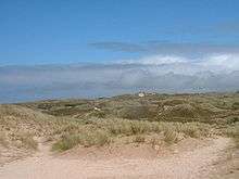
In 1910, a coal-fired power station was built on the northern flank of Hayle Towans beside the mouth of the River Hayle. The station was in use from 1910 until it closed in 1973.[17] The buildings were demolished soon after closure but the station's legacy can still be seen in the overhead transmission lines which cross the dunes, particularly at the southern section of The Towans (see photo).
Folklore
It is said that in a gale the turrets of a castle belonging to Theodoric can be seen. Once king of Cornwall he is notorious for beheading an Irish saint who came to Cornwall in the 5th-century.[18]
References
- ↑ Place-names in the Standard Written Form (SWF) : List of place-names agreed by the MAGA Signage Panel. Cornish Language Partnership.
- ↑ Into Cornwall website; Place Names in Cornwall. Retrieved June 2010
- ↑ Ordnance Survey: Landranger map sheet 203 Land's End ISBN 978-0-319-23148-7
- 1 2 Ordnance Survey: Explorer map (scale 1:25000); sheet 102 Land's End, Penzance & St Ives ISBN 978-0-319-24116-5
- ↑ Cornwall Council online mapping. Retrieved June 2010
- ↑ GENUKI website; Phillack. Retrieved June 2010
- ↑ "Gwithian to Mexico Towans citation" (PDF). Sites of Special Scientific Interest. Natural England. 1987. Retrieved 4 December 2011.
- ↑ "Map of Gwithian To Mexico Towans". Sites of Special Scientific Interest. Natural England. Retrieved 4 August 2013.
- 1 2 "Upton Towans Nature Reserve". Cornwall Wildlife Trust. Archived from the original on 14 January 2011. Retrieved 4 December 2011.
- ↑ "Upton Towans". Local Nature Reserves. Natural England. Retrieved 4 August 2013.
- ↑ "Map of Upton Towans". Local Nature Reserves. Natural England. Retrieved 4 August 2013.
- ↑ "Gwithian Towans". Local Nature Reserves. Natural England. Retrieved 4 August 2013.
- ↑ "Map of Gwithian Towans". Local Nature Reserves. Natural England. Retrieved 4 August 2013.
- ↑ Thomas, Charles (1964). "Minor sites in the Gwithian area (Iron Age to recent times)". Cornish Archaeology Hendhyscans Kernow. 3: 37–62.
- ↑ "Towans". The Cornishman (53). 17 July 1879.
- ↑ Holmes, Jonathan (1995). The Archive Photographs Series St Ives Bay. Stroud: Chalford Publishing Company. ISBN 0 7524 0186 6.
- ↑ "Electricity In Cornwall - Part 2 - Cornwall Electric Power Company" (PDF). 3 April 2009. Retrieved 8 April 2010.
- ↑ "The Sands and their Legends.". The Cornishman (10). 19 September 1878. p. 3.
Cornwall Portal | |
| Unitary authorities | |
| Major settlements |
|
| Rivers | |
| Topics | |