Topo da Coroa
| Topo da Coroa | |
|---|---|
|
View of the mountain summit (in the background) | |
| Highest point | |
| Elevation | 1,979 m (6,493 ft) [1] |
| Prominence | 1,979 m (6,493 ft) [1] |
| Listing | Ultra |
| Coordinates | 17°01′57″N 25°17′45″W / 17.03250°N 25.29583°WCoordinates: 17°01′57″N 25°17′45″W / 17.03250°N 25.29583°W |
| Geography | |
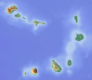 Topo da Coroa Location in Cape Verde, | |
| Location | Santo Antão, Cape Verde |
| Geology | |
| Mountain type | Stratovolcano |
| Last eruption | around 200,000 years ago |
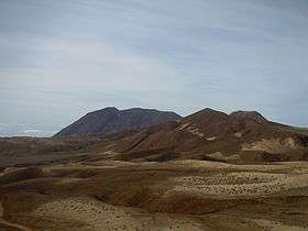
Topo da Coroa or Tope de Coroa is a mountain on the island of Santo Antão's, Cape Verde. At 1,979 m elevation, it is the highest point of the island and the second tallest mountain of Cape Verde after Pico do Fogo (2,829 m) and before Chã das Caldeiras (around 1,870 m) nationally and Monte Tomé (1,863 m) in the island. It is in the western part of the island. The mountain is entirely of volcanic origin and much of it is made of basalt. It is 25 km west of the island capital Porto Novo.
About the summit
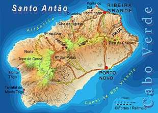
The area are the source of several streams including Ribeira do Tarrafal which flows westward to Tarrafal de Monte Trigo.
The mountain forms part of a natural park.[2] It contains 61% of the endemic angiosperm plants of Cape Verde, of which 25% are in the red list of endangered species. The causes relate to overgrazing.[3]
Its last eruption took place over 200,000 years ago and was a Plinian eruption and shrunk the Trigo Bay around 500 meters (1,500 feet). Much of the western terrain are of lava flows of the last eruption and made the Coroa and Tarrafal Group of rock formations.[4]
The Proto-Coroa Group of rock formation formed around 400,000 years ago which is largely now covered over the two later rock formations,, it mainly consists of nephelite rocks.
During the Ice Age, its mountain elevation was around 2,100 meters tall (over 2,000 meters), when sea levels rose, 5,000 years ago, its elevation dropped below the height of 2,000 meters above sea level.
The peak has a lot of flora, of which much of it are flowers or grasses, those listed endangered includes Tornabenea insularis.
See also
References
- 1 2 "Africa Ultra-Prominences" Peaklist.org. Retrieved 2012-04-22.
- ↑ Áreas protegidas, Cabo Verde (Portuguese)
- ↑ "Tope de Coroa. Auf den höchsten Berg der Insel", Wandern auf den Kapverdischen Inseln, DuMont, 2001, p. 124-128 ISBN 978-3770153688
- ↑ Holm, Paul Martin (2006). Sampling the Cape Verde Mantle Plume: Evolution of Melt Compositions on Santo Antão, Cape Verde Island. 47. p. 145-18. doi:10.1093/petrology/egi071.
Bibliography
- Reitmeier, Pitt and Fortes, Lucete. Goldstadt Hiking Map Santo Antão 1: 50,000. Goldstadt-Verlag 2008. ISBN 3-89550-467-X
- Ricardo A. S. Ramalho, Building the Cape Verde Islands, Springer, 2011, p. 207 ISBN 9783642191022
External links
- Áreas protegidas, Cabo Verde (Portuguese)