Ribeira da Garça
| Ribeira da Garça | |
|---|---|
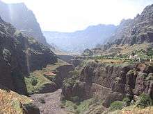 The Garça Valley at Chã da Igreja in 2008, since 2014, the road crosses through and behind the cliff is the Canto de Cagarra Dam | |
| Country | Cape Verde |
| Basin | |
| Main source |
Gudo de Cavaleiro, Santo Antão |
| River mouth |
Atlantic Ocean 17°09′58″N 25°10′12″W / 17.166°N 25.170°WCoordinates: 17°09′58″N 25°10′12″W / 17.166°N 25.170°W |
| Physical characteristics | |
| Length | 8 km (5.0 mi) |
Ribeira da Garça[1] is a river in the northern part of the island of Santo Antão in Cape Verde. Its source is on the north side of the main range of the island. It flows north through the settlements Garça de Cima and Chã de Igreja and the west of the municipality of Ribeira Grande, and drains into the Atlantic Ocean in the north nearly 10 km west of Ribeira Grande. Hamlets located near or by the stream includes Horta da Garça, Cagarra, Manta Velha and Fundo. Parts of the river features some cliffs that are 30 to 40 meters high.
The stream starts in Lombo de Gudo as Cabuco Dragum located north of Gudo dos Moroços (1,604 m) inside Moroços Natural Park, it is also north of Gudo de Cavaleiro (1,810 m).
Midway in the area where the reservoirs stands is a mountain to the east and further east is the source of Ribeira Grande.
Canto de Cagarra Dam
The Canto de Cagarra Dam (Barragem de Canto de Cagarra) has been constructed and was finished on November 16, 2014,[2] the only large dam on the island located roughly in the middle of the stream. The reservoir is predominantly dry and are being the two in Cape Verde, the other is Salineiro on the Ribeira Grande de Santiago north of Cidade Velha on Santiago Island.
Hurricane Fred filled up Canto de Cagarra dam on September 2015 and irrigated drought-stricken lands.[3]
Gallery
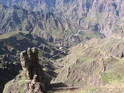 View of the head of the valley
 Mouth of the Ribeira da Garça. The alluvial terrace, 40 meters above sea level, is clearly visible
See also
References
- ↑ http://dialnet.unirioja.es/servlet/fichero_articulo?codigo=2800296&orden=0
- ↑ "Santo Antão: Barragem de Canto de Cagarra foi inaugurada hoje" [Canto de Cagarra Dam to be Completed Today]. Inforpress (in Portuguese). 15 November 2014. Retrieved 16 November 2014.
- ↑ "Chuvas fazem transbordar barragens de Faveta e de Canto de Cagarra" [Rainfall Filled Up the Dams of Faveta and Canto de Cagarra]. A Semana (in Portuguese). Praia. 2015-09-02. Retrieved 2015-09-20.
External links
- Photos of Ribeira da Garça and its valley at ecaboverde.com
- « Nótula sobre aspectos recentes e actuais da erosão fluvial na ilha de Santo Antão » (article by Suzanne Daveau in Finisterra. Revista portuguesa de geografia, vol. XXIV, no. 46, 1988, p. 287-301) (Portuguese)
Further reading
- Carlos Ferrão, Estudos sobre a Ilha de Santo Antão, Imprensa Nacional, Lisbon, 1898, 116 p.
| Parishes | 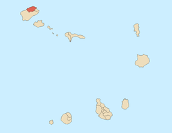 | |
|---|---|---|
| Communities and settlements | ||
| Geographical features |
| |
| Landmarks and points of Interests | ||
| Defunct airport | ||
| Culture |
| |