Gudo de Cavaleiro
| Gudo de Cavaeiro | |
|---|---|
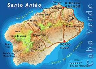 Map of Santo Antão Island, the summit is next to Alto Mira | |
| Highest point | |
| Elevation | 1,811 m (5,942 ft) |
| Prominence | 1,811 m (5,942 ft) |
| Listing | List of mountains in Cape Verde |
| Coordinates | 17°08′0″N 21°57′0″W / 17.13333°N 21.95000°WCoordinates: 17°08′0″N 21°57′0″W / 17.13333°N 21.95000°W |
| Geography | |
 Gudo de Cavaeiro southeastern Santo Antão | |
| Geology | |
| Mountain type | Stratovolcano (extinct) |
| Last eruption | unknown |
| Climbing | |
| First ascent | unknown |
| Easiest route | road and hiking |
Gudo de Caveliro is a mountain in the middle of the island Santo Antão in Cape Verde. It is the island's third highest point elevating 1,811 meters after Monte Tomé and Topo da Coroa. Nearby places includes Alto Mira to the west. It is in the Lagoa area and the Ribeira Grande-Porto Novo municipal boundary runs near the summit and there the western boundary heads northwest. Around the peak to its north, it is the source of Ribeira da Garça, a stream that flows north up to the Atlantic, 6 km west-southwest of Fontainhas.
Rock formations includes that of the Lagoa Group and parts of the Coroa Group consisting of nephelite rocks, it was formed in around 400,000 to 100,000 years ago. [1]
Up above it has panoramic views of much of the island including its nearby valleys and except for Tarrafal de Monte Trigo and the outer parts of the island's northern part, it has a view of Canal de São Vicente along with the island of São Vicente and its adjacent islands and the western part of São Nicolau.
See also
References
- ↑ Holm, Paul Martin (2006). Sampling the Cape Verde Mantle Plume: Evolution of Melt Compositions on Santo Antão, Cape Verde Island. 47. p. 145-18. doi:10.1093/petrology/egi071.
Further reading
- REITMEIER, Pitt e FORTES, Lucete. Goldstadt Hiking Map Santo Antão 1: 50,000. Goldstadt-Verlag 2008. ISBN 3-89550-467-X
External links
| Parishes |  | |
|---|---|---|
| Communities and settlements | ||
| Geographical features |
| |
| Landmarks and points of Interests | ||
| Defunct airport | ||
| Culture |
| |