Pico da Cruz
| Pico da Cruz | |
|---|---|
 Pico da Cruz | |
| Highest point | |
| Elevation | 1,585 m (5,200 ft) |
| Listing | List of mountains in Cape Verde |
| Coordinates | 17°06′11″N 25°01′52″W / 17.10306°N 25.03111°WCoordinates: 17°06′11″N 25°01′52″W / 17.10306°N 25.03111°W |
| Geography | |
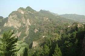
 Pico da Cruz eastern Santo Antão | |
| Geology | |
| Mountain type | Stratovolcano |
| Climbing | |
| Easiest route | climb |
Pico da Cruz (Portuguese meaning "peak of the cross") is a mountain in the eastern part of the island of Santo Antão. Its maximum elevation is 1585 m.[1] It is 5 km southwest of the town Pombas (Paul). The mountain is of volcanic origin. It gives its name to the village of Pico da Cruz is some hundreds of meters to the west and forms a part of the municipality of Paul. The Paul-Porto Novo municipal boundary (also the Pico da Cruz-Ribeirão Frio communal and the natural park boundary) is around the area bordering 300 meters soufh.
Pico da Cruz forms a part of a protected area known as the Cova-Ribeira da Torre-Paul Natural Park.
Much of the area within the peak are forested. Flora includes laurisilva and other pines, some deciduous trees and smaller plants, especially endangered ones including Tornabenea insularis.
The area offers panoramic views incuding the Ribeira do Paul, Ribeira da Janela, the east of Porto Novo and the south of the island and the island of São Vicente and its surrounding islets.
See also
References
| Parish |  | |
|---|---|---|
| Communities and settlements | ||
| Geographical features |
| |
| Landmarks and points of Interests | ||
| Culture | ||