Townsend, Tennessee
| Townsend, Tennessee | |
|---|---|
| City | |
|
Townsend at sunrise | |
| Motto: Gateway to Cades Cove | |
 Location of Townsend, Tennessee | |
| Coordinates: 35°40′32″N 83°45′18″W / 35.67556°N 83.75500°WCoordinates: 35°40′32″N 83°45′18″W / 35.67556°N 83.75500°W | |
| Country | United States |
| State | Tennessee |
| County | Blount |
| Founded | 1901 |
| Incorporated | 1921[1] |
| Named for | Wilson B. Townsend |
| Area | |
| • Total | 2.2 sq mi (5.6 km2) |
| • Land | 2.2 sq mi (5.6 km2) |
| • Water | 0.0 sq mi (0.0 km2) |
| Elevation | 1,070 ft (326 m) |
| Population (2010) | |
| • Total | 448 |
| • Density | 207/sq mi (79.9/km2) |
| Time zone | Eastern (EST) (UTC-5) |
| • Summer (DST) | EDT (UTC-4) |
| ZIP code | 37882 |
| Area code(s) | 865 |
| FIPS code | 47-74860[2] |
| GNIS feature ID | 1272813[3] |
| Website |
www |

Townsend is a city in Blount County, Tennessee, in the southeastern United States. The population was 244 at the 2000 census and 448 at the 2010 census.[4] For thousands of years a site of Native American occupation by varying cultures, Townsend is one of three "gateways" to the Great Smoky Mountains National Park. It has several museums and attractions relating to the natural and human history of the Great Smokies.
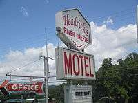
Identifying as "The Peaceful Side of the Smokies," Townsend has the least traffic of the three main entrances to the national park. The park's other two entrances— one just south of Gatlinburg, Tennessee, and the other just north of Cherokee, North Carolina— are home to multiple commercial attractions that draw millions of tourists annually. Townsend is low-key, with a handful of inexpensive restaurants and motels and several businesses geared toward outdoor sports, and a world-renowned horse show.
History
Native Americans were the first inhabitants of Tuckaleechee Cove on the Little River; the oldest archaeological finds in the cove date to 2000 B.C. A number of pottery fragments and ax heads dating to the Woodland period have also been found. By 1200 A.D., Tuckaleechee's Native American inhabitants had built a fortified village near the cove's northern entrance.[5]
The Cherokee arrived in the area around 1600, and built a series of small villages along Little River. The name "Tuckaleechee" is from the Cherokee Tikwalitsi, and its original meaning is unknown.[6] A branch of the Great Indian Warpath forked at this site, with one branch heading west to the Overhill towns along the Little Tennessee River and another heading south to North Carolina.[7] 19th-century anthropologist James Mooney recounted an attempted raid on the Cherokee villages in Tuckaleechee by the Shawano (Shawnee) in the mid-18th century. The raid was thwarted when a Cherokee conjurer named Deadwood Lighter envisioned the position of the Shawano ambush. The Cherokee surprised the raiders from the rear, killing many of them and chasing the rest back over the crest of the Smokies.[8]
By the time the first Euro-American settlers arrived in Tuckaleechee in the late 18th century, the Cherokee had abandoned these villages. They moved south and west to evade encroachment by the colonists.[7]
In 1843, humorist George Washington Harris published an account of a country dance held that year in Tuckaleechee ("Tuck-a-lucky") Cove on the farm of "Capt. Dillon." Moonshine, cornbread, eggs and ham were served, and revelers danced to music provided by a fiddle-and-dulcimer duo. To win dance partners, the men engaged in a display of "feats of strength", while the women quilted.[9]
Logging industry
In the 1880s, the lumber industry experienced a boom, aided by two key innovations— the bandsaw and the logging railroad. Flatland forest resources in the Ohio Valley and along the Mississippi Delta were quickly exhausted by the high demand for wood for fuel for steamboats. Logging firms began turning to the untapped resources of more mountainous areas.[10]
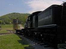
In 1900, hoping to capitalize on the thick virgin forests of the Smokies, Colonel W.B. Townsend of Pennsylvania purchased 86,000 acres (350 km2) of land along the Little River, stretching from Tuckaleechee Cove all the way to Clingmans Dome. The following year, Townsend received a charter for his new firm, the Little River Lumber Company. He had a bandsaw mill erected in Tuckaleechee, and the community that developed around the mill was named after him. The Little River Railroad was constructed shortly thereafter, connecting the sawmill with Walland to the west, and following the Little River upstream to Elkmont to the southeast.[10]
Townsend quickly profited from the forests of the Little River bottomlands. In 1916, he reported that Little River Lumber's consistently-high rate of planks-per-acre was showing no sign of decline. A single giant chestnut tree in the Smokies could yield 18,000 planks of lumber. Townsend's success led to a rapid expansion of logging operations throughout the Smokies.[10] By the time the park was formed in the 1930s, nearly two-thirds of area forests had been cut down, and park managers have worked to restore the forests.[11]
The rapid destruction of the forests of southern Appalachia led to increased efforts by conservationists to slow or halt logging operations. Col. Townsend initially opposed the effort, but after some wavering, sold at base price 76,000 acres (310 km2) of his Little River Lumber tract in 1926 to what would eventually become the Great Smoky Mountains National Park.[12] Although some predicted that the loss of the lumber industry would doom Tuckaleechee, the explosion in tourism as a result of the park's founding has contributed to the area economy, keeping it relatively healthy.[13]
Geography
Townsend is located in eastern Blount County at 35°40′32″N 83°45′18″W / 35.67556°N 83.75500°W (35.675471, -83.755012).[14] It is situated in Tuckaleechee Cove, one of several "limestone windows" that dot the northern base of the Smokies. These windows form when erosional forces carry away the older rocks (mostly sandstone), exposing the younger rock below (i.e., limestone).[15] Limestone windows are normally flatter than other mountainous valleys, and are typically coated with rich, fertile soil.
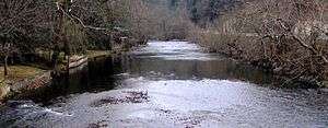
Other limestone windows in the area include Cades Cove, Wear Cove, and Jones Cove. Tuckaleechee Cove is situated between Bates Mountain to the north and Rich Mountain to the south, with the cove's greater population estimated at around 1,500. The Little River, its source high in the mountains on the north slopes of Clingmans Dome,[16] slices east-to-west through Tuckaleechee and drains much of the cove. The city of Townsend dominates the eastern half of Tuckaleechee.
According to the United States Census Bureau, the city has a total area of 2.2 square miles (5.6 km2), all land.[4] As of 2004, annexation had considerably increased the size of the town to its current size. Townsend is included in the Knoxville Metropolitan Statistical Area.
Demographics
| Historical population | |||
|---|---|---|---|
| Census | Pop. | %± | |
| 1930 | 402 | — | |
| 1940 | 378 | −6.0% | |
| 1950 | 328 | −13.2% | |
| 1960 | 283 | −13.7% | |
| 1970 | 267 | −5.7% | |
| 1980 | 351 | 31.5% | |
| 1990 | 329 | −6.3% | |
| 2000 | 244 | −25.8% | |
| 2010 | 448 | 83.6% | |
| Est. 2015 | 452 | [17] | 0.9% |
| Sources:[18][19] | |||
As of the census[2] of 2000, there were 244 people, 124 households, and 80 families residing in the city. The population density was 265.7 people per square mile (102.4/km²). There were 217 housing units at an average density of 236.3 per square mile (91.1/km²). The racial makeup of the city was 97.95% White, 1.23% Native American and 0.82% Asian.
There were 124 households out of which 15.3% had children under the age of 18 living with them, 58.9% were married couples living together, 3.2% had a female householder with no husband present, and 34.7% were non-families. 33.1% of all households were made up of individuals and 23.4% had someone living alone who was 65 years of age or older. The average household size was 1.97 and the average family size was 2.44.
In the city the population was spread out with 12.3% under the age of 18, 2.5% from 18 to 24, 19.3% from 25 to 44, 36.5% from 45 to 64, and 29.5% who were 65 years of age or older. The median age was 56 years. For every 100 females there were 86.3 males. For every 100 females age 18 and over, there were 86.1 males.
The median income for a household in the city was $36,250, and the median income for a family was $50,000. Males had a median income of $41,071 versus $29,375 for females. The per capita income for the city was $21,647. About 5.9% of families and 12.1% of the population were below the poverty line, including 7.7% of those under the age of eighteen and 11.5% of those sixty five or over.
Transportation
U.S. 321, also known as Lamar Alexander Parkway and Wears Valley Road, is the main highway connecting Townsend with Walland (and eventually Maryville) to the northwest and Pigeon Forge (via Wears Valley) to the east-northeast, where it intersects U.S. 441. Near the eastern end of Townsend, U.S. 321 tees north and then curves northeast, while Tennessee 73 continues straight and then turns southeast and heads straight into the national park. This road eventually intersects Little River Road at a popular swimming area known as "The Y". From this intersection, Cades Cove is 7 miles (11 km) to the west, and the Sugarlands and Gatlinburg are roughly 18 miles (29 km) to the east.
Recreation
Townsend is home to the Great Smoky Mountains Heritage Center, which preserves various aspects of the region's history, and the Little River Railroad and Lumber Company Museum, which recounts the area's logging history. Next to the heritage center is the new National Park Service Collections Preservation Center, which archives items from all of the national park units in the area (though not open to the public). Tuckaleechee Caverns – a mile-long cave system that reaches depths of up to 150 feet (46 m) – is also nearby.
Just to the north and west of Townsend, the Foothills Parkway is a national parkway that traverses Chilhowee Mountain and offers multiple scenic overlooks at high elevations, with views of the Smokies to the south and the Tennessee Valley and Cumberland Plateau to the north and west. As of 2016, road construction on the parkway to complete the "missing link" from Walland to Wears Valley can be seen from Townsend during the mid-day and afternoon. It is expected to open in 2017, more than half a century after the first section opened in 1966.
See also
References
- ↑ Tennessee Blue Book, 2005-2006, pp. 618-625.
- 1 2 "American FactFinder". United States Census Bureau. Retrieved 2008-01-31.
- ↑ "US Board on Geographic Names". United States Geological Survey. 2007-10-25. Retrieved 2008-01-31.
- 1 2 "Geographic Identifiers: 2010 Demographic Profile Data (G001): Townsend city, Tennessee". U.S. Census Bureau, American Factfinder. Retrieved April 8, 2014.
- ↑ Iva Butler, "Archaeologists Pack Up Townsend Dig," The Maryville-Alcoa Daily Times, 17 February 2001.
- ↑ James Mooney, Myths of the Cherokee and Sacred Formulas of the Cherokee (Nashville: Charles Elder, 1972), 534.
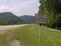
- 1 2 Tennessee Historical Commission marker IE 15 along US-321, Townsend, Tennessee. Information accessed in August, 2007.
- ↑ Mooney, page 374.
- ↑ George Washington Harris, M. Thomas Inge (ed.), "Sporting Epistle From East Tennessee," High Times and Hard Times (Nashville: Vanderbilt University Press, 1967), pp. 28-31. Originally published in the Spirit of the Times, 2 September 1843.
- 1 2 3 Michael Frome, Strangers in High Places: The Story of the Great Smoky Mountains (Knoxville: University of Tennessee Press, 1994), 165-166.
- ↑ "History", Smoky Mountains Visitors Guide
- ↑ Carlos Campbell, Birth of a National Park in the Great Smoky Mountains (Knoxville: University of Tennessee Press, 1969), 33-35.
- ↑ Frome, page 192.
- ↑ "US Gazetteer files: 2010, 2000, and 1990". United States Census Bureau. 2011-02-12. Retrieved 2011-04-23.
- ↑ Harry Moore, A Roadside Guide to the Geology of the Great Smoky Mountains National Park (Knoxville, Tennessee: University of Tennessee Press, 1988), 33.
- ↑ http://www.topozone.com/map.asp?lat=35.57888&lon=-83.48574&size=l&u=4&datum=nad27&layer=DRG
- ↑ "Annual Estimates of the Resident Population for Incorporated Places: April 1, 2010 to July 1, 2015". Retrieved July 2, 2016.
- ↑ "Census of Population and Housing: Decennial Censuses". United States Census Bureau. Retrieved 2012-03-04.
- ↑ "Incorporated Places and Minor Civil Divisions Datasets: Subcounty Resident Population Estimates: April 1, 2010 to July 1, 2012". Population Estimates. U.S. Census Bureau. Retrieved 11 December 2013.
External links
- City of Townsend official website
- Smoky Mountain Convention & Visitors Bureau
- Townsend Chamber of Commerce
- About Townsend
- Great Smoky Mountains Heritage Center
- Little River Railroad and Lumber Company Museum - Site with museum information and photographs from early 20th century
- Great Smoky Mountains Institute at Tremont
- Mary E. Tippitt Memorial Library
Municipalities and communities of Blount County, Tennessee, United States | ||
|---|---|---|
| Cities | ||
| Towns | ||
| CDPs | ||
| Unincorporated communities | ||
| Footnotes | ‡This populated place also has portions in an adjacent county or counties | |