Trambileno
| Trambileno | |
|---|---|
| Comune | |
| Comune di Trambileno | |
 Trambileno Location of Trambileno in Italy | |
| Coordinates: 45°52′N 11°4′E / 45.867°N 11.067°ECoordinates: 45°52′N 11°4′E / 45.867°N 11.067°E | |
| Country | Italy |
| Region | Trentino-Alto Adige/Südtirol |
| Province / Metropolitan city | Trentino (TN) |
| Area | |
| • Total | 50.3 km2 (19.4 sq mi) |
| Elevation | 525 m (1,722 ft) |
| Population (Dec. 2004) | |
| • Total | 1,309 |
| • Density | 26/km2 (67/sq mi) |
| Time zone | CET (UTC+1) |
| • Summer (DST) | CEST (UTC+2) |
| Postal code | 38068 |
| Dialing code | 0464 |
Trambileno (German: Trumbeleis) is a comune (municipality) in Trentino in the northern Italian region Trentino-Alto Adige/Südtirol, located about 25 kilometres (16 mi) south of Trento. As of 31 December 2004, it had a population of 1,309 and an area of 50.3 square kilometres (19.4 sq mi).[1]
Trambileno borders the following municipalities: Rovereto, Terragnolo, Vallarsa, Posina and Valli del Pasubio.
It is known as the location of the Eremo di San Colombano monastery, a picturesque church set on a rock ledge.
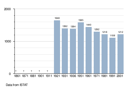
Demographic evolution
References

This article is issued from Wikipedia - version of the 1/31/2015. The text is available under the Creative Commons Attribution/Share Alike but additional terms may apply for the media files.