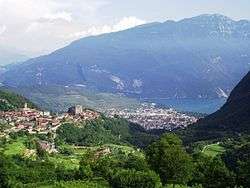
Tenno, Trentino
This article is about the Italian city. For other uses, see Tenno (disambiguation).
| Tenno | |
|---|---|
| Comune | |
| Comune di Tenno | |
 | |
 Tenno Location of Tenno in Italy | |
| Coordinates: 45°55′N 10°50′E / 45.917°N 10.833°ECoordinates: 45°55′N 10°50′E / 45.917°N 10.833°E | |
| Country | Italy |
| Region | Trentino-Alto Adige/Südtirol |
| Province / Metropolitan city | Trentino (TN) |
| Frazioni | Gavazzo, Cologna, Ville del Monte, Pranzo |
| Area | |
| • Total | 28.3 km2 (10.9 sq mi) |
| Elevation | 428 m (1,404 ft) |
| Population (Dec. 2004) | |
| • Total | 1,823 |
| • Density | 64/km2 (170/sq mi) |
| Demonym(s) | Tennesi |
| Time zone | CET (UTC+1) |
| • Summer (DST) | CEST (UTC+2) |
| Postal code | 38060 |
| Dialing code | 0464 |
| Website | Official website |
Tenno (Tem in local dialect, German: Tinnebach or Thenn) is a comune (municipality) in Trentino in the northern Italian region Trentino-Alto Adige/Südtirol, located about 30 kilometres (19 mi) southwest of Trento. As of 31 December 2004, it had a population of 1,823 and an area of 28.3 square kilometres (10.9 sq mi).[1]
The municipality of Tenno contains the frazioni (subdivisions, mainly villages and hamlets) Gavazzo, Cologna, Ville del Monte and Pranzo.
Tenno borders the following municipalities: Comano Terme, Fiavè, Arco, Ledro and Riva del Garda.
Tenno contains the waterfalls of Cascate del Varone.
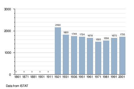
Demographic evolution
See also
- Lomano
- Concei
References
External links
 Media related to Tenno at Wikimedia Commons
- Homepage of the city (Italian)
- Tenno tourist information

This article is issued from Wikipedia - version of the 5/25/2015. The text is available under the Creative Commons Attribution/Share Alike but additional terms may apply for the media files.