Transport in Saudi Arabia
With the arrival of petrodollars, the Kingdom of Saudi Arabia has initiated many mega infrastructure development projects in the country, and the extensive development of the transportation network has followed suit in support of various economic developments. As a result, the country now boasts an extensive transportation network.
Road transportation
Total: 221,372 km (137,554 mi)
Paved: 47,529 km (29,533 mi) (includes 3,891 km (2,418 mi) of expressways)
Unpaved: 173,843 km (108,021 mi) (as of 2006)
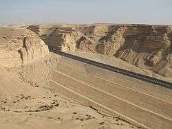
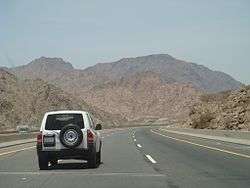
Roads in Saudi Arabia vary from eight-laned roads to small two-lane roads in rural areas. The city highways and other major highways are well maintained, especially the roads in the capital Riyadh. The roads have been constructed to resist the consistently high temperatures and do not reflect the strong sunshine. The other city highways such as the one linking coast to coast are not as great as the inner-city highways but the government is now working on rebuilding those roads. In October 2013, a group of auto enthusiasts drove some 2,000 km (1,200 mi) through Saudi Arabia in search of the best driving road, and named the Jeddah-Taif-Al-Hada highway as "motoring nirvana".[1]
Saudi Arabia encourages road transport as it has maintained one of the lowest petrol prices in the world, at $0.48 per gallon ($0.13 per liter).[2]
Some of the important inter-city highways include the following:[3][4]
- Dammam - Abu Hadriya - Ras Tanura Highway 257 km (160 mi)
- Khaybar - Al Ola Highway 175 km (109 mi)
- Mecca - Madinah Al Munawarah Highway 421 km (262 mi)
- Riyadh - Dammam Highway 383 km (238 mi)
- Riyadh - Sudair - Al Qasim Highway 317 km (197 mi)
- Riyadh - Taif Highway 750 km (470 mi)
- Taif - Abha - Jizan Highway 750 km (470 mi)
- Medina - Tabuk Highway 680 km (420 mi)
- Jeddah - Al Leith - Jizan Highway 775 km (482 mi)
- Jeddah - Mecca Highway 80 km (50 mi)
Sea transportation
Saudi Arabia has a well development sea transport network developed primarily to support the transport of petrochemicals. Saudi Ports Authority is the ports management organization in the country, overseeing the operations.
The major ports in the country are as follows;
Persian Gulf
- King Abdul Aziz Port, Dammam
- Jubail
- Ras Tanura
- Khafji
- Khobar
- Ras Al-Zour (under construction)
Red Sea
Air transportation
There are an estimated 203 airports in Saudi Arabia (2003 est.).
Airports with paved runways
total:
61
over 3,047 m:
32
2,438 to 3,047 m:
13
1,524 to 2,437 m:
12
914 to 1,523 m:
2
under 914 m:
2 (2003 est.)
Airports with unpaved runways
total:
133
over 3047 m:
1
2,438 to 3,047 m:
5
1,524 to 2,437 m:
75
914 to 1,523 m:
38
under 914 m:
14 (2003 est.) (Saudia is the nation's flag carrier airline)
Helicopters
9 (2009 est.)
Rail transport
As a result of over-reliance on road and air travel, the rail transport has not received a similar level of investment in Saudi Arabia. However, there are now plans to add more tracks and develop new railway routes.
There is a large scale railway project Haramain High Speed Rail Project underway in the Western province, connecting Makkah with Jeddah and Madinah city. The primary objective of this railway line is to provide an alternative for the Muslim pilgrims travelling between the three cities.
The Al Mashaaer Al Mugaddassah Metro Southern Line is part of the Makkah Metro rail transit system, which was developed in Makkah city. This is a 18.1 kilometers (11.2 miles) track developed as exclusive shuttle a forecasted 8 million pilgrims between Mecca, Mount Arafat, Muzdalifa and Mina in the annual Hajj pilgrimage.
References
- ↑ http://www.crankandpiston.com/on-the-road/mclaren-12c-saudi-arabia-the-hidden-kingdom/
- ↑ http://www.csmonitor.com/World/Americas/2011/0913/World-s-cheapest-gas-Top-5-countries/Saudi-Arabia-0.48-per-gallon-0.13-per-liter
- ↑ Saoudi inter-city highways
- ↑ http://www.saudia-online.com/newsnov01/news06.shtml
Saudi Arabia articles | |||||||||||||
|---|---|---|---|---|---|---|---|---|---|---|---|---|---|
| History |  | ||||||||||||
| Geography | |||||||||||||
| Politics |
| ||||||||||||
| Economy | |||||||||||||
| Society |
| ||||||||||||
| |||||||||||||
| Lines |
| ||||||||||||||
|---|---|---|---|---|---|---|---|---|---|---|---|---|---|---|---|
| Organizations |
| ||||||||||||||
| Rolling Stock |
| ||||||||||||||