Tur'an
Tur'an
| ||
|---|---|---|
| Hebrew transcription(s) | ||
| • ISO 259 | Ṭurˁan, Turˁan | |
|
Abu Baker Sadic Mosque, Tur'an, 2011 | ||
| ||
 Tur'an | ||
| Coordinates: 32°46′36.97″N 35°22′32.43″E / 32.7769361°N 35.3756750°ECoordinates: 32°46′36.97″N 35°22′32.43″E / 32.7769361°N 35.3756750°E | ||
| Grid position | 185/242 PAL | |
| District | Northern | |
| Government | ||
| • Type | Local council (from 1959) | |
| Population (2015)[1] | ||
| • Total | 13,337 | |
| Name meaning | Possibly from "an outlet of water", Syriac form[2] | |
.JPG)
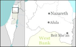
Tur'an (Arabic: طرعان, Hebrew: תֻּרְעָן) is an Arab town in the Northern District of Israel. It is located at the foot of Mount Tur'an and the Tur'an Valley, near the main road from Haifa to Tiberias, and about 7 kilometres (4.3 mi) north of Nazareth.[3] In 2015 it had a population of 13,337.
History
Pottery and building remains from the Iron Age I have been excavated in the village. Apparently Tur'an was at that time (12-11th centuries B.C.E.) surrounded by a city wall.[4]
The Palestine Exploration Fund's Survey of Western Palestine (SWP) found caves and rock-cut cisterns in the village, which they noted appeared to be an ancient site.[5]
The village was known in the Roman and Byzantine periods (Mishnaic and Talmudic times, respectively) as Tir'an. It was a Jewish village whose inhabitants probably converted to Islam by the end of the early Islamic Arab period (7th-10th centuries) in Palestine.[6]
Pottery from the early Islamic (7th century CE), and Mamluk (14th century CE) have also been excavated, together with building remains from the same period.[7]
Ottoman era
In 1517, Tur'an was with the rest of Palestine incorporated into the Ottoman Empire after it was captured from the Mamluks, and by 1596, it appeared in the Ottoman tax registers as being in the nahiya of Tabariyya in the liwa of Safad. It had a population of 48 households, all Muslim. The villagers paid taxes on wheat, barley, olive trees, fruit trees, goats and/or beehives.[8][9]
A map from Napoleon's invasion of 1799 by Pierre Jacotin showed the place, though misplaced, named as Touran.[10]
In 1848, William F. Lynch described Tur'an as "quite a fortification."[11] The French explorer Victor Guérin visited Tur'an in 1870, and estimated it had 350 Muslims and 200 "Greeks".[12] In 1881, the Palestine Exploration Fund's Survey of Western Palestine (SWP) described it as "A stone village, partly built of basalt, containing about 300 inhabitants, half Christian, half Moslem.[..] The village is situated al the foot of the hills, and is surrounded by groves of olives. There is a good spring to the north-west."[13]
British Mandate era
In a census conducted in 1922 by the British Mandate authorities, Tur'an had a population of 768; 542 Muslims and 226 Christians.[14] Of the Christians, 52 were Orthodox and 174 were Melkite.[15] The population had increased in the 1931 census to 961; 693 Muslims and 268 Christians, in a total of 188 occupied houses.[16]
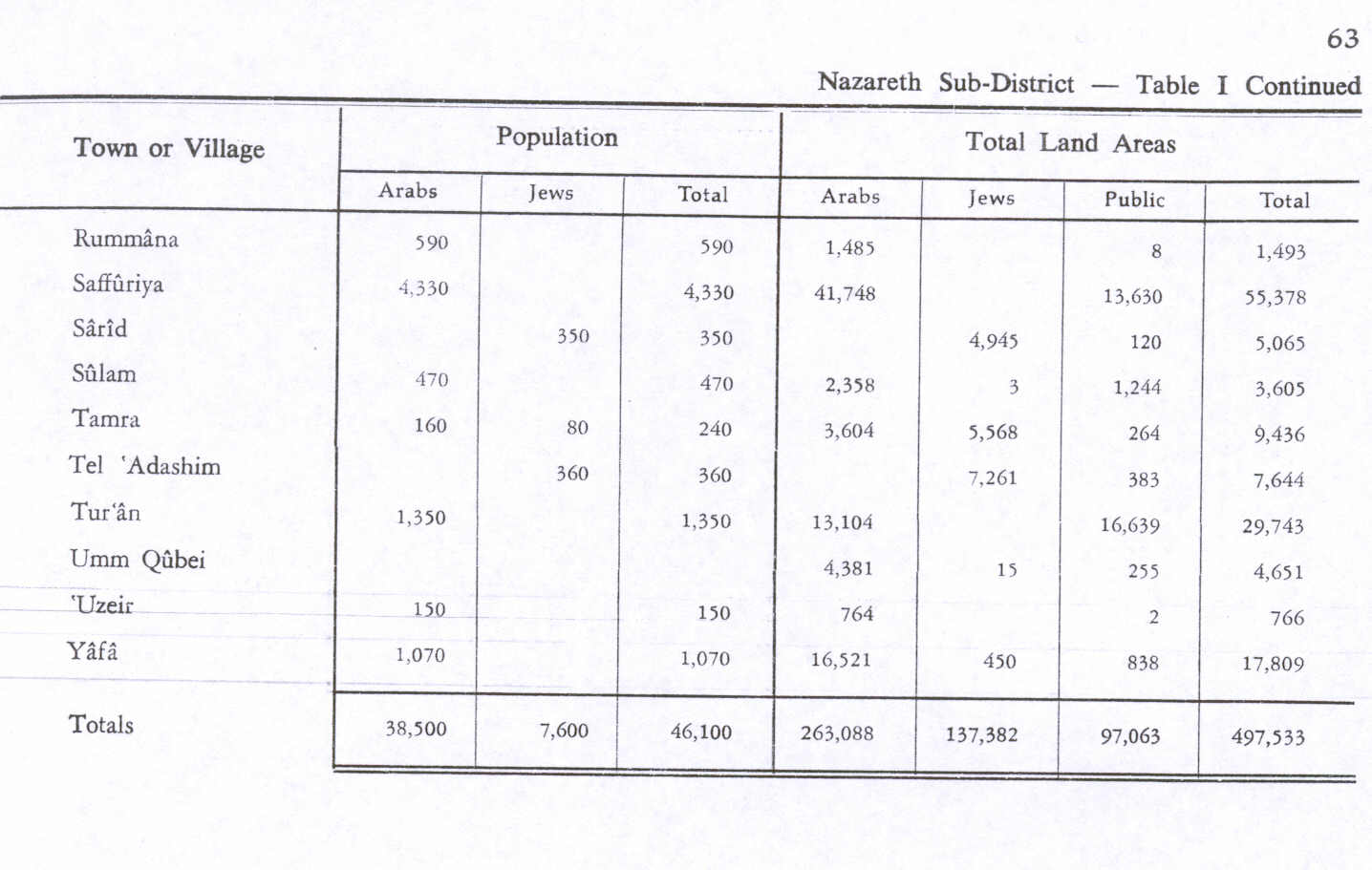
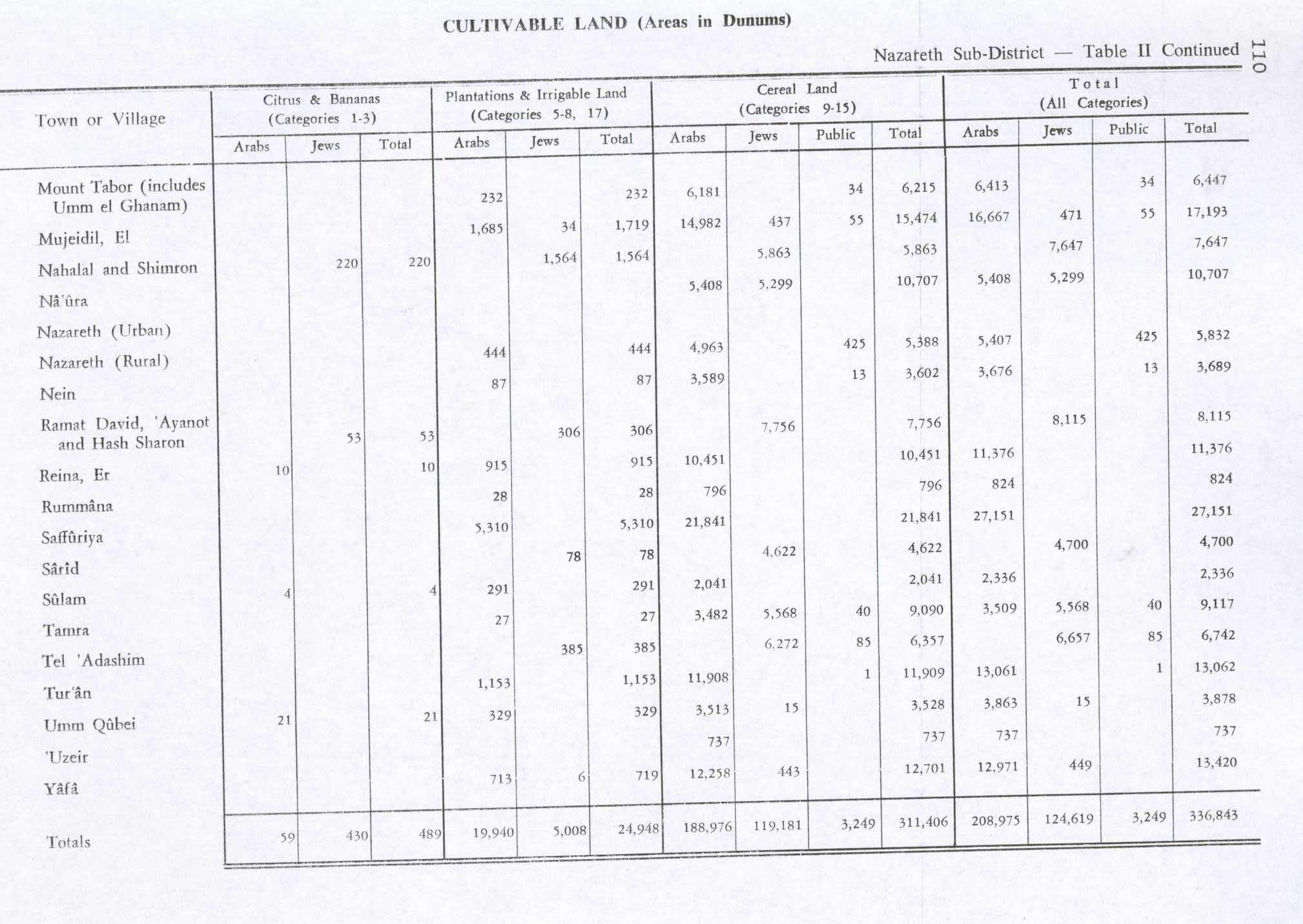
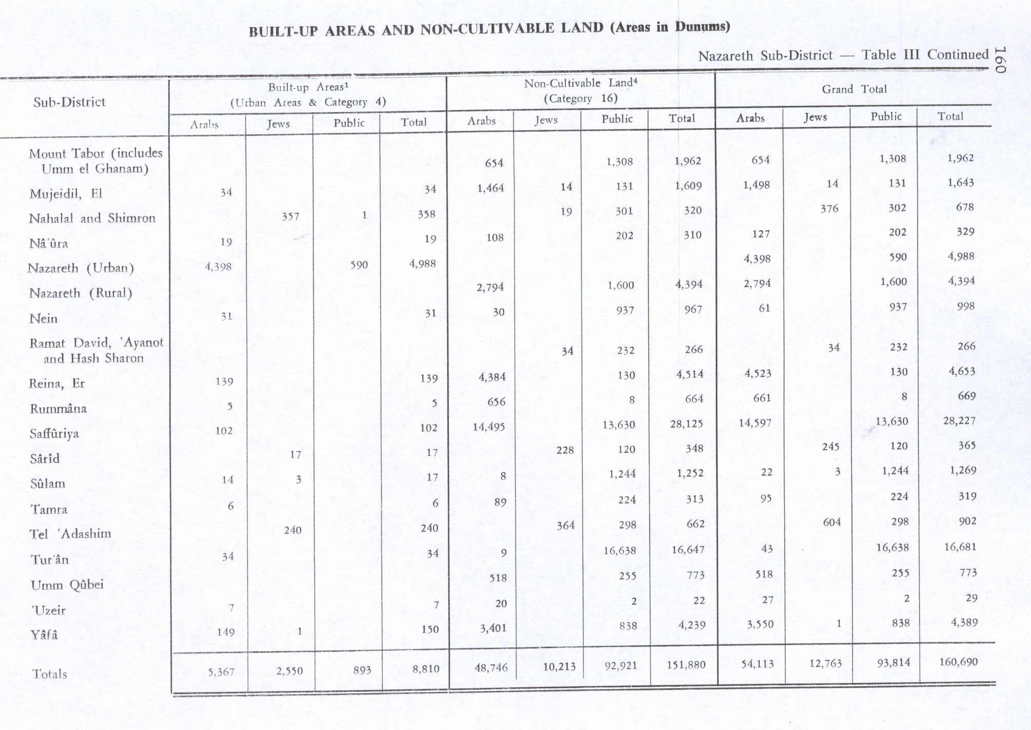
In 1945 the population was 1,350, all Arabs, with 29,743 dunams of land, according to an official land and population survey.[17] Of this, 1,153 dunams were for plantations and irrigable land, 11,909 for cereals,[18] while 34 dunams were built-up land.[19]
State of Israel
On 18 July 1948 the Israeli captured Tur'an during the second part of Operation Dekel. The houses of those villagers who had fled were later used to house Arab refugees from neighbouring villages. The village remained under Martial Law until 1966.[20][21]
See also
References
- ↑ "List of localities, in Alphabetical order" (PDF). Israel Central Bureau of Statistics. Retrieved 16 October 2016.
- ↑ Palmer, 1881, pp. 123, 136
- ↑ Tur'an (Israel)
- ↑ Massarwa, 2010, Tur‘an
- ↑ Conder and Kitchener, 1881, SWP I, p. 418
- ↑ "Tur'an" in Mapa - Israel's Geography Site
- ↑ Mokary, 2009, Tur‘an, Final Report
- ↑ Hütteroth and Abdulfattah, 1977, p. 188.
- ↑ Note that Rhode, 1979, p. 6 writes that the register that Hütteroth and Abdulfattah studied from the Safad-district was not from 1595/6, but from 1548/9
- ↑ Karmon, 1960, p. 166.
- ↑ Lynch, 1849, pp. 140 - 144
- ↑ Guérin, 1880, pp. 182-183
- ↑ Conder and Kitchener, 1881, SWP I, pp. 363-364
- ↑ Barron, 1923, Table XI, Sub-district of Nazareth, p. 38
- ↑ Barron, 1923, Table XVI, p. 51
- ↑ Mills, 1932, p. 76
- ↑ Government of Palestine, Department of Statistics. Village Statistics, April, 1945. Quoted in Hadawi, 1970, p. 63
- ↑ Government of Palestine, Department of Statistics. Village Statistics, April, 1945. Quoted in Hadawi, 1970, p. 110
- ↑ Government of Palestine, Department of Statistics. Village Statistics, April, 1945. Quoted in Hadawi, 1970, p. 160
- ↑ Morris, 1987, pp. 200, 253.
- ↑ O'Ballance, Edgar (1956) The Arab-Israeli War. 1948. Faber & Faber, London. p.160.
Bibliography
| Wikimedia Commons has media related to Tur'an. |
- Barron, J. B., ed. (1923). Palestine: Report and General Abstracts of the Census of 1922. Government of Palestine.
- Conder, Claude Reignier; Kitchener, H. H. (1881). The Survey of Western Palestine: Memoirs of the Topography, Orography, Hydrography, and Archaeology. 1. London: Committee of the Palestine Exploration Fund.
- Guérin, Victor (1880). Description Géographique Historique et Archéologique de la Palestine (in French). 3: Galilee, pt. 1. Paris: L'Imprimerie Nationale.
- Hadawi, Sami (1970). Village Statistics of 1945: A Classification of Land and Area ownership in Palestine. Palestine Liberation Organization Research Center.
- Hütteroth, Wolf-Dieter; Abdulfattah, Kamal (1977). Historical Geography of Palestine, Transjordan and Southern Syria in the Late 16th Century. Erlanger Geographische Arbeiten, Sonderband 5. Erlangen, Germany: Vorstand der Fränkischen Geographischen Gesellschaft. ISBN 3-920405-41-2.
- Karmon, Y. (1960). "An Analysis of Jacotin's Map of Palestine" (PDF). Israel Exploration Journal. 10 (3,4): 155–173; 244–253.
- Lynch, William F. (1849). Narrative of the United States' Expedition to the River Jordan and the Dead Sea. London: Richard Bentley.
- Massarwa, Abdalla (2010-09-26). "Tur'an Final Report" (122). Hadashot Arkheologiyot – Excavations and Surveys in Israel.
- Mills, E., ed. (1932). Census of Palestine 1931. Population of Villages, Towns and Administrative Areas. Jerusalem: Government of Palestine.
- Moktari, Abdalla (2009-12-30). "Tur'an Final Report" (121). Hadashot Arkheologiyot – Excavations and Surveys in Israel.
- Morris (1987). The Birth of the Palestinian Refugee Problem. Cambridge University Press. ISBN 0-521-33028-9.
- Palmer, E. H. (1881). The Survey of Western Palestine: Arabic and English Name Lists Collected During the Survey by Lieutenants Conder and Kitchener, R. E. Transliterated and Explained by E.H. Palmer. Committee of the Palestine Exploration Fund.
- Rhode, Harold (1979). Administration and Population of the Sancak of Safed in the Sixteenth Century. Columbia University.
External links
- Official website (Arabic)
- Welcome To Tur'an
- Survey of Western Palestine, Map 6: IAA, Wikimedia commons