U.S. Route 41 in Wisconsin
| ||||
|---|---|---|---|---|
|
US 41 highlighted in red | ||||
| Route information | ||||
| Maintained by WisDOT | ||||
| Length: | 225 mi (362 km) | |||
| Existed: | 1926 – present | |||
| Major junctions | ||||
| South end: |
| |||
| North end: |
| |||
| Location | ||||
| Counties: | Kenosha, Racine, Milwaukee, Waukesha, Washington, Dodge, Fond du Lac, Winnebago, Outagamie, Brown, Oconto, Marinette | |||
| Highway system | ||||
| ||||

-map.png)
U.S. Highway 41 (US 41) is a north–south highway United States Numbered Highway in eastern Wisconsin. It runs from Pleasant Prairie on the Illinois border north to Marinette on the Michigan border. Most of the route is concurrent with Interstate 41 in the state, with the exception of the portion between Howard and Marinette.
Route description
US 41 is a freeway for nearly 85 percent of its route through Wisconsin, with the exceptions being a 29-mile (55 km) expressway section from the US 141 interchange in Oconto County to Marinette and a 5-mile (8 km) surface arterial section within Marinette. The highway is concurrent with I-94 from Milwaukee to the Illinois border and concurrent with I-41 from Howard to the Illinois border.
US 41 runs northwest from Milwaukee and passes Fond du Lac, Oshkosh, and Appleton before heading to Green Bay. The route is a major access point for Miller Park, home of the Milwaukee Brewers Major League Baseball club, the EAA AirVenture Oshkosh air show in Oshkosh, and for Lambeau Field, the home of the Green Bay Packers NFL football team.
After leaving Green Bay, US 41 continues north to Abrams co-signed with US 141, and then it turns east off the co-signed route toward Marinette and into Michigan.
History
In Milwaukee the original routing of US 41 used Lisbon Avenue east to North 27th Street, then south along that road to the Illinois state line. After the Stadium Freeway was built in the 1960s, US 41 followed that road from Lisbon Avenue south across I-94 to National Avenue and then east to 27th Street, which is known as Layton Boulevard between National Avenue and Lincoln Avenue. WisDOT rerouted US 41 along I-94 from the Stadium Interchange to the Illinois state line, removed Layton Boulevard north of Forest Home Avenue from the state highway system and gave Layton Boulevard and 27th Street south of Forest Home Avenue the designation of WIS 241 in a compromise to avoid expansion of the original route. The old US 41 freeway section south of I-94 to National Avenue (which was realigned to accommodate the construction of Miller Park) was designated WIS 341 but is unsigned. Trailblazer signs label it Miller Park Way.
By 1955, US 41 was relocated from the corridor of today's WIS 175 and its successors to a nearby expressway in Winnebago, Fond du Lac, Dodge, Washington, Waukesha, and Milwaukee Counties.[1]
In Green Bay, the road used to make a curve to the right west of De Pere, going onto Ashland Avenue to the Green Bay city limits. It then turned left onto Highland Avenue (after 1968, Lombardi Avenue), going past Lambeau Field and curving right onto Military Avenue. It then turned left at Velp Avenue. At the time from about 1956 to 1968 this was the outer highway for Green Bay, and the site for Lambeau Field was chosen because of highway access. The area now is urbanized. It then followed present day Velp Avenue north to Suamico where it merged with what is now the US 41 freeway. The original Green Bay bypass was once again bypassed with the present US 41 freeway beginning at Velp, southerly to Lombardi in 1968; Velp north to Suamico in 1971; then from Lombardi south to De Pere in 1974.[1]
Appleton also saw US 41 realignments over the course of time, beginning with the 1937 two-lane bypass (along the present freeway route) from Neenah northerly to a T-intersection with US 10 (today's Wisconsin Avenue, WIS 96). There, US 41 turned east with US 10, back to its original route at the intersection of US 10 (Wisconsin Avenue) and Richmond Street north of downtown Appleton, then north on Richmond to present day Northland Avenue. There it turned east on new alignment back to the original route northeast of Kaukauna. In 1940, US 41 was extended northerly from the T-intersection at US 10 for one mile (1.6 km), before making a large sweeping curve onto present day Northland Avenue to join back up with the previous bypass at Richmond Street. By 1962, the original Appleton bypass had been converted to four-lane divided highway from Oshkosh north to Northland Avenue, then north and east on new alignment bypassing the Northland Avenue bypass with the current freeway easterly to Kaukauna.
Current status
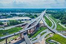
US 41 is being upgraded to Interstate Highway standards between Milwaukee and Green Bay. Interchange upgrades are underway on US 41 near Fond du Lac, Oshkosh and Green Bay. By the end of 2015, US 41 will be converted from the existing four-lane freeway to a six-lane freeway in both Milwaukee and Green Bay. US 41 has also been upgraded to four-lane expressway between Oconto and Peshtigo, which includes freeway bypasses of both cities. The Oconto-to-Peshtigo stretch, which had been the last remaining two-lane segment of US 41 in the state, opened as a four-lane expressway between the two cities in November 2008. The Oconto and Peshtigo bypasses were completed November 19, 2009. At present, US 41 is constructed to freeway standards from the Illinois border to the US 41/US 141 interchange in south-central Oconto County, approximately 19 miles (31 km) north of Green Bay.
Exit list
| County | Location | mi[2] | km | Exit[3] | Destinations | Notes |
|---|---|---|---|---|---|---|
| Kenosha | Pleasant Prairie | 0.00 | 0.00 | Continuation into Illinois | ||
| 2.04 | 3.28 | 347 | ||||
| 3.43 | 5.52 | 345 | ||||
| Kenosha | 5.07 | 8.16 | 344 | |||
| Town of Somers | 6.59 | 10.61 | 342 | |||
| 8.35 | 13.44 | 340 | ||||
| Town of Paris | 10.07 | 16.21 | 339 | |||
| Racine–Kenosha county line | Mount Pleasant–Paris village/town line | 12.08 | 19.44 | 337 | ||
| Racine | Mount Pleasant | 13.95 | 22.45 | 335 | ||
| Town of Yorkville | 15.96– 16.01 | 25.69– 25.77 | 333 | |||
| Caledonia | 19.64 | 31.61 | 329 | |||
| Town of Raymond | 21.67 | 34.87 | 327 | |||
| 23.17 | 37.29 | 326 | Seven Mile Road | |||
| Caledonia | 24.10 | 38.79 | 325 | Northbound exit and southbound entrance | ||
| Milwaukee | Oak Creek | 324 | Elm Road | Future exit, will replace exit 325 | ||
| 26.39 | 42.47 | 322 | ||||
| 28.47 | 45.82 | 321 | Drexel Avenue | |||
| 29.41 | 47.33 | 320 | ||||
| Milwaukee | 30.38 | 48.89 | 319 | |||
| 31.08 | 50.02 | 318 | ||||
| 32.37 | 52.09 | 317 | ||||
| 32.53– 32.69 | 52.35– 52.61 | 10 316 | Mitchell Interchange; northern end of I-94 concurrency; eastern end of I-43 wrong-way concurrency; eastern end of I-894 concurrency | |||
| 33.60 | 54.07 | 9 | No access is allowed from I-94 west or to I-94 east; exit numbers based on I-894's mile markers | |||
| Greenfield | 34.64 | 55.75 | 8 | Signed as exits 8A and 8B | ||
| 35.64 | 57.36 | 7 | South 60th Street | |||
| 36.66 | 59.00 | 5B | Westbound exit and eastbound entrance | |||
| 36.66– 37.14 | 59.00– 59.77 | 5A-B | South 76th Street, South 84th Street | Eastbound exit and westbound entrance | ||
| 36.86 | 59.32 | 5A | Westbound exit and eastbound entrance | |||
| Milwaukee | 38.06 | 61.25 | 4 | Hale Interchange; western end of I-43 concurrency; southern end of the US 45 concurrency | ||
| Greenfield | 39.32 | 63.28 | 3 | |||
| 39.93 | 64.26 | 2B | Oklahoma Avenue | Southbound exit and northbound entrance | ||
| West Allis | 40.67 | 65.45 | 2A | National Avenue | Southbound exit to westbound National Avenue only | |
| 40.93 | 65.87 | 1E | Lincoln Avenue | Southbound exit and northbound entrance | ||
| 41.89 | 67.42 | 1D | ||||
| Milwaukee | 42.61 | 68.57 | 1 38 | Western end of I-894 concurrency; signed as exits 1A (east) and 1B (west) northbound and exits 38A (west) and 38B (east) southbound; Zoo Interchange | ||
| Wauwatosa | 43.36– 43.60 | 69.78– 70.17 | 39 | Northbound exit is not signed for Wisconsin Avenue; exit numbers based on US 45's mile markers | ||
| 44.14– 44.56 | 71.04– 71.71 | 40 | Watertown Plank Road, Swan Boulevard | Soutbound exit not signed for Swan Boulevard | ||
| 44.94 | 72.32 | 42A | Southbound exit not signed for WIS 100 | |||
| 45.54 | 73.29 | 42B | North Avenue west | |||
| 46.59 | 74.98 | 43 | Burleigh Street | |||
| 47.59 | 76.59 | 44 | Three-level diamond interchange; access roads for the adjacent Harley-Davidson and Penzeys Spices plants are also part of the interchange | |||
| Milwaukee | 48.69 | 78.36 | 45 | |||
| 49.52 | 79.69 | 46 | Southern end of WIS 100 concurrency | |||
| 51.05 | 82.16 | 47 | ||||
| 51.85 | 83.44 | 47B | Exit numbers based on US 41's mile markers | |||
| 52.15– 52.94 | 83.93– 85.20 | 48 | ||||
| Waukesha | Menomonee Falls | 54.64– 54.77 | 87.93– 88.14 | 50 | Northern end of WIS 100 concurrency; signed as exits 50A (east) and 50B (west) | |
| 55.45 | 89.24 | 51 | Pilgrim Road | Signed as exits 51A (north) and 51B (south) | ||
| Washington | Germantown | 56.68 | 91.22 | 52 | ||
| 58.63 | 94.36 | 54 | Southern end of WIS 167 concurrency | |||
| 61.64 | 99.20 | 57 | Northern end of WIS 167 concurrency | |||
| Richfield | 63.27 | 101.82 | 59 | Northern end of US 45 concurrency; northbound exit and southbound entrance | ||
| 64.37 | 103.59 | 60 | Signage reads WIS 145; ramp signage reads CTH-FD TO WIS 145 | |||
| Slinger | 68.17 | 109.71 | 64 | Signed as exits 64A (east, Jackson) and 64B (west, Slinger, Hartford) northbound. Commerce Blvd | ||
| Town of Polk | 70.45 | 113.38 | 66 | |||
| Town of Hartford | 72.12 | 116.07 | 68 | |||
| Town of Addison | 76.37 | 122.91 | 72 | |||
| Town of Wayne | 79.59 | 128.09 | 76 | |||
| Dodge | Town of Theresa | 85.22 | 137.15 | 81 | ||
| Lomira | 89.24 | 143.62 | 85 | |||
| Town of Lomira | 91.29 | 146.92 | 87 | |||
| Fond du Lac | Town of Byron | 96.10 | 154.66 | 92 | ||
| Fond du Lac | 99.71– 99.72 | 160.47– 160.48 | 95 | Southern end of US 45 overlap | ||
| 101.01 | 162.56 | 97 | ||||
| 101.84 | 163.90 | 98 | Former US 151 | |||
| 103.74 | 166.95 | 99 | Northern end of US 45 overlap | |||
| North Fond du Lac | 104.24 | 167.76 | 101 | |||
| Winnebago | Town of Eldorado | 110.27 | 177.46 | 106 | ||
| Town of Nekimi | 117.47 | 189.05 | 113 | |||
| Oshkosh | 120.22 | 193.48 | 116 | |||
| Oshkosh | 121.64 | 195.76 | 117 | 9th Avenue | ||
| Oshkosh | 123.14 | 198.17 | 119 | |||
| Oshkosh | 125.05 | 201.25 | 120 | To US 10 west not signed southbound | ||
| Oshkosh | 128.10 | 206.16 | 124 | |||
| Neenah | 133.30 | 214.53 | 129 | Bell Street, Breezewood Lane | ||
| 134.67 | 216.73 | 131 | ||||
| 135.61 | 218.24 | 132 | Main Street, Oak Ridge Road | No entrance ramps | ||
| Town of Menasha | 136.35 | 219.43 | 133 | |||
| 137.81 | 221.78 | 134 | ||||
| 137.86 | 221.86 | Southbound exit and entrance only | ||||
| 139.62 | 224.70 | 136 | ||||
| Outagamie | Town of Grand Chute | 140.88 | 226.72 | 137 | ||
| 141.65 | 227.96 | 138 | ||||
| 142.71 | 229.67 | 139 | To CTH-A not signed southbound | |||
| 145.67 | 234.43 | 142 | ||||
| Appleton | 147.67 | 237.65 | 144 | |||
| 148.59– 148.61 | 239.13– 239.16 | 145 | ||||
| Town of Little Chute | 151.10 | 243.17 | 146 | |||
| Kaukauna | 152.78 | 245.88 | 148 | |||
| 153.99 | 247.82 | 150 | ||||
| Town of Kaukauna | 158.25 | 254.68 | 154 | |||
| Brown | Town of Lawrence | 161.21 | 259.44 | 157 | ||
| 181.87 | 292.69 | 161 | ||||
| Ashwaubenon | 167.12 | 268.95 | 163A | Signed as exit 163 southbound | ||
| 167.40 | 269.40 | 163B | Northbound exit and southbound entrance | |||
| 168.39 | 271.00 | 164 | ||||
| 169.36– 169.46 | 272.56– 272.72 | 165 | To WIS 57 not signed northbound | |||
| 171.14 | 275.42 | 167 | ||||
| Green Bay | 172.18 | 277.10 | 168 | Southern end of WIS 32 concurrency | ||
| Howard | 173.17 | 278.69 | 169 | Northern end of WIS 32 concurrency | ||
| 174.75 | 281.23 | 170 | Southern end of US 141 concurrency | |||
| 175.16– 175.43 | 281.89– 282.33 | 171 | Northern terminus of I-41 and I-43; northern end of I-41 concurrency | |||
| Town of Suamico | 173 | |||||
| 176 | ||||||
| Oconto | Town of Little Suamico | 179 | Brown Road | |||
| 182 | ||||||
| Town of Abrams | 185 | |||||
| 187 | Northern end of US 141 concurrency; northern end of freeway and southern end of expressway | |||||
| Town of Pensaukee | At-grade intersection | |||||
| Oconto | 197 | Northbound exit and southbound entrance only | ||||
| 198 | ||||||
| 200 | Northbound entrance and southbound exit only | |||||
| Lena | Two at-grade intersections; southern intersection is CTH-A east and northern intersection is CTH-A west | |||||
| Marinette | County Line | At-grade intersection | ||||
| Grover | At-grade intersection | |||||
| Peshtigo | 212 | |||||
| 216 | ||||||
| Marinette | 219 | At-grade intersection | ||||
| At-grade intersection | ||||||
| Menominee River | Continuation into Michigan | |||||
1.000 mi = 1.609 km; 1.000 km = 0.621 mi
| ||||||
See also
 U.S. Roads portal
 Wisconsin portal
References
- 1 2 Bessert, Christopher J. (January 31, 2009). "US 41, The Complete History". Wisconsin Highways. Self-published. Retrieved December 14, 2006.
- ↑ Wisconsin State Trunk Highway Logs:
- Southeast Region Staff (December 31, 2008). State Trunk Highway Log for Southeast Region (XLS). Waukesha, WI: Wisconsin Department of Transportation. 041N.
- Southwest Region Staff (December 31, 2008). State Trunk Highway Log for Southwest Region (XLS). Madison, WI: Wisconsin Department of Transportation. 041N.
- Northeast Region Staff (May 14, 2009). State Trunk Highway Log for Region 3. Green Bay, WI: Wisconsin Department of Transportation. pp. 172–200.
- ↑ Staff. "Exit Numbers on US 41". Wisconsin Department of Transportation. Retrieved June 10, 2007.
External links
| Wikimedia Commons has media related to U.S. Route 41 in Wisconsin. |
| Previous state: Illinois |
Wisconsin | Next state: Michigan |