Unimak Island
| Native name: <span class="nickname" ">Unimax[1] | |
|---|---|
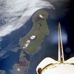 Unimak Island from space, September 1992 (viewed from Shuttle Endeavour on STS-47) | |
 Unimak | |
| Geography | |
| Location | Northern Pacific Ocean |
| Coordinates | 54°46′06″N 164°11′12″W / 54.76833°N 164.18667°W |
| Archipelago | Aleutian Islands |
| Area | 1,571.41 sq mi (4,069.9 km2) |
| Length | 95 km (59 mi) |
| Width | 116 km (72.1 mi) |
| Highest elevation | 9,373 ft (2,856.9 m) |
| Highest point | Mount Shishaldin |
| Administration | |
| State | Alaska |
| Borough | Aleutians East |
| Demographics | |
| Population | 64 (2000) |
| Pop. density | 0.02 /km2 (0.05 /sq mi) |
Unimak Island (Aleut: Unimax[1]) is the largest island in the Aleutian Islands chain of the U.S. state of Alaska.
Geography
It is the easternmost island in the Aleutians and, with an area of 1,571.41 square miles (4,069.93 square kilometres), the ninth largest island in the United States and the 134th largest island in the world. It is home to Mount Shishaldin, one of the ten most active volcanoes in the world. According to the United States Census Bureau, there were 64 people living on Unimak as of the 2000 census, all of them in the city of False Pass at the eastern end of the island. Cape Lutke is a headland on the island.
The Fisher Caldera is a volcanic crater in the west-central part of Unimak. Some characteristics include many volcanic cones and undrained lakes. It is named for Bernard Fisher, a U.S. Geological Survey geologist who was killed in Umnak Pass.
Mount Westdahl, 5,426 feet (1,654 m) in elevation, is a stratovolcano of the Aleutian Range on the island.
Natural history
When the Alaska National Interest Lands Conservation Act was passed on 2 December 1980, 910,000 acres (370,000 ha) of the island was designated as wilderness.[2] This area is managed by the United States Fish and Wildlife Service.
As a faunal extension of the Alaska Peninsula, Unimak has a relatively diverse assemblage of terrestrial mammals, including Alaskan brown bears and caribou. West of Unimak Island, the largest native mammal in the Aleutians is the red fox.
Buildings
Scotch Cap Lighthouse was built in 1903[3] and was manned by the US Coast Guard. On April 1, 1946, during the 1946 Aleutian Islands earthquake, the lighthouse was struck by a tsunami. Even though the lighthouse was 98 feet (30 m) above the sea, the lighthouse slid into the sea, killing five Coast Guard personnel.[4]
Cape Sarichef Lighthouse is also on the island.
- Airports
See also
- Islands of Aleutians East Borough, Alaska
- Extreme points of the United States
References
- Notes
- 1 2 Bergsland, K. (1994). Aleut Dictionary. Fairbanks: Alaska Native Language Center.
- ↑ "Unimak Wilderness". Retrieved 2014-11-17.
- ↑ http://www.titanic-nautical.com/Lighthouses-AK-Scotch-Cap.html
- ↑ DrGeorgePC website with photos
- Further reading
- Titanic and Nautical Resource Center
- Unimak Island: Blocks 1046 thru 1049 and 1055 thru 1065, Census Tract 1, Aleutians East Borough, Alaska United States Census Bureau
External links
| Wikimedia Commons has media related to Unimak Island. |
Coordinates: 54°46′06″N 164°11′12″W / 54.76833°N 164.18667°W