Boulder, Utah
| Boulder, Utah | |
|---|---|
| Town | |
|
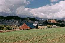
From the Hogsback of Highway 12, the ranching and farming community of Boulder nestles amidst rugged terrain. | |
 Location in Garfield County and state of Utah. | |
| Coordinates: 37°55′28″N 111°25′34″W / 37.92444°N 111.42611°WCoordinates: 37°55′28″N 111°25′34″W / 37.92444°N 111.42611°W | |
| Country | United States |
| State | Utah |
| County | Garfield |
| Settled | c. 1890 |
| Named for | Boulder Mountain |
| Government | |
| • Mayor | Bill Muse |
| • Clerk | Judith Davis |
| Area | |
| • Total | 20.9 sq mi (54.2 km2) |
| • Land | 20.9 sq mi (54.2 km2) |
| • Water | 0.0 sq mi (0.0 km2) |
| Elevation | 6,703 ft (2,043 m) |
| Population (2012) | |
| • Total | 220 |
| • Density | 8.6/sq mi (3.3/km2) |
| Time zone | MST (UTC-7) |
| • Summer (DST) | MDT (UTC-6) |
| ZIP code | 84716 |
| Area code(s) | 435 |
| FIPS code | 49-07470[1] |
| GNIS feature ID | 1437510[2] |

Boulder is a town in Garfield County, Utah, United States, 27 miles (44 km) northeast of Escalante on Utah Scenic Byway 12 at its intersection with the Burr Trail. As of the 2000 census, the town population was 180, a modest increase over the 1990 figure of 126.
Boulder, quite isolated until the Civilian Conservation Corps built a road from Escalante, did not get electric power until 1947. The town marks the western terminus of Burr Trail, a mostly paved road that runs eastward through spectacular red rock country to the Waterpocket Fold in Grand Staircase-Escalante National Monument. Boulder is the home of Anasazi Indian State Park.
Geography
Boulder is located near Grand Staircase-Escalante National Monument and Capitol Reef National Park.
According to the United States Census Bureau, the town has a total area of 20.9 square miles (54.2 km²), none of which is covered with water. Boulder also has many sandstone formations, such as small mountains and slopes.
Climate
According to the Köppen Climate Classification system, Boulder has a semi-arid climate, abbreviated "BSk" on climate maps.[3]
Demographics
| Historical population | |||
|---|---|---|---|
| Census | Pop. | %± | |
| 1900 | 104 | — | |
| 1910 | 91 | −12.5% | |
| 1920 | 177 | 94.5% | |
| 1930 | 192 | 8.5% | |
| 1940 | 216 | 12.5% | |
| 1950 | 197 | −8.8% | |
| 1960 | 108 | −45.2% | |
| 1970 | 93 | −13.9% | |
| 1980 | 113 | 21.5% | |
| 1990 | 126 | 11.5% | |
| 2000 | 180 | 42.9% | |
| 2010 | 226 | 25.6% | |
| Est. 2015 | 223 | [4] | −1.3% |
As of the census[1] of 2000, there were 180 people, 65 households, and 41 families residing in the town. The population density was 8.6 people per square mile (3.3/km²). There were 102 housing units at an average density of 4.9 per square mile (1.9/km²). The racial makeup of the town was 96.67% White, 1.11% Asian, 0% African American, 0% Native American, 0% Pacific Islander, 0% from other races, and 2.22% from two or more races. Hispanic or Latino of any race were 1.11% of the population.
There were 65 households out of which 33.8% had children under the age of 18 living with them, 52.3% were married couples living together, 4.6% had a female householder with no husband present, and 36.9% were non-families. 27.7% of all households were made up of individuals and 9.2% had someone living alone who was 65 years of age or older. The average household size was 2.77 and the average family size was 3.54.
In the town the population was spread out with 30.0% under the age of 18, 11.1% from 18 to 24, 26.7% from 25 to 44, 21.1% from 45 to 64, and 11.1% who were 65 years of age or older. The median age was 34 years. For every 100 females there were 104.5 males. For every 100 females age 18 and over, there were 103.2 males.
The median income for a household in the town was $30,000, and the median income for a family was $31,429. Males had a median income of $20,750 versus $12,083 for females. The per capita income for the town was $9,583. About 15.2% of families and 13.3% of the population were below the poverty line, including 6.5% of those under the age of eighteen and 14.3% of those sixty five or over.
References
- 1 2 "American FactFinder". United States Census Bureau. Archived from the original on 2013-09-11. Retrieved 2008-01-31.
- ↑ "US Board on Geographic Names". United States Geological Survey. 2007-10-25. Retrieved 2008-01-31.
- ↑ Climate Summary for Boulder, Utah
- ↑ "Annual Estimates of the Resident Population for Incorporated Places: April 1, 2010 to July 1, 2015". Retrieved July 2, 2016.
- ↑ "Census of Population and Housing". Census.gov. Archived from the original on May 11, 2015. Retrieved June 4, 2015.
External links
- Official Town Website
- History from a Bureau of Land Management website
- History from the Boulder Business Alliance website
 |
Koosharem | Bicknell, Torrey | Capitol Reef National Park / Hanksville | |
| Antimony | |
Colorado River / Monticello Blanding | ||
| ||||
| | ||||
| Escalante | |
Glen Canyon National Recreation Area |
Municipalities and communities of Garfield County, Utah, United States | ||
|---|---|---|
| Cities | 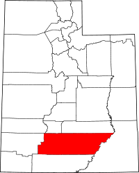 | |
| Towns | ||
| Unincorporated communities | ||
| Ghost towns | ||