Feke
| Feke | |
|---|---|
 Feke | |
| Coordinates: 37°48′54″N 35°54′45″E / 37.81500°N 35.91250°ECoordinates: 37°48′54″N 35°54′45″E / 37.81500°N 35.91250°E | |
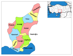
| Country | Turkey |
| Province | Adana |
| Government | |
| • Mayor | Ahmet Sel (MHP) |
| • Kaymakam | Bünyamin Kuş |
| Area[1] | |
| • District | 1,227.13 km2 (473.80 sq mi) |
| Elevation | 620 m (2,030 ft) |
| Population (2012)[2] | |
| • Urban | 4,608 |
| • District | 18,055 |
| • District density | 15/km2 (38/sq mi) |
| Post code | 01660 |
| Website |
www |
Feke (Armenian: Վահկա or Vahka) is a small city and a district in Adana Province of Turkey, 122 km from the city of Adana, 620m above sea-level, a small town on attractive forested mountainside. The current mayor is Ahmet Sel (MHP).
History
The area was settled by the Hittites in the 16th century BC, the Persians in the 6th century BC, conquered by Alexander the Great in 333 BC, and later passed into the hands of the Romans and Byzantines.
Feke commands a pass across the Taurus mountains directly north of Adana, and a castle was first built in the Byzantine period. The name then was Vahka and has since mutated to today's spelling Feke.
Beginning in the 10th century AD the Byzantine government forcibly settled Armenians into Cilicia to act as guards on the frontier with Syria. With the collapse of Byzantine rule in Asia Minor after the Battle of Manzikert it fell upon the Armenians in Cilicia to defend themselves and in 1097/98 they captured this castle and rebuilt most of the Greek fortifications. It became an important stronghold for the Rubenid barons, who later became the rulers of the Armenian Kingdom of Cilicia. It was captured by the Mameluks and then the Ottomans.
Below the castle are the imposing remains of a two-story early Byzantine church and a late antique/medieval town.[3]
The impressive circuit walls, towers, and vaulted chambers of the castle are positioned at the top of an elongated mountainous outcrop, primarily flanking the more accessible western side.[4] Sheer cliffs precluded the need for defenses at the east. The outer gatehouse, which consists of a winding staircase and an elaborate bent entrance, leads to the summit. Here there are cisterns, residential quarters, and embrasured loopholes for archers. Most of the exterior masonry is the typical Armenian rusticated ashlar with finely drafted margins.
References
- ↑ "Area of regions (including lakes), km²". Regional Statistics Database. Turkish Statistical Institute. 2002. Retrieved 2013-03-05.
- ↑ "Population of province/district centers and towns/villages by districts - 2012". Address Based Population Registration System (ABPRS) Database. Turkish Statistical Institute. Retrieved 2013-02-27.
- ↑ Edwards, Robert W., “Settlements and Toponymy in Armenian Cilicia,” Revue des Études Arméniennes 24, 1993, pp.203-04.
- ↑ Edwards, Robert W. (1987). The Fortifications of Armenian Cilicia: Dumbarton Oaks Studies XXIII. Washington, D.C.: Dumbarton Oaks, Trustees for Harvard University. pp. 259–265, 286, pls.260a–269a. ISBN 0-88402-163-7.