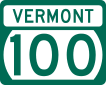
Vermont Route 100
| ||||
|---|---|---|---|---|
| 43rd Infantry Division Memorial Highway | ||||
|
Map of Vermont with VT 100 highlighted in red | ||||
| Route information | ||||
| Maintained by VTrans | ||||
| Length: | 216.666 mi[1] (348.690 km) | |||
| Major junctions | ||||
| South end: |
| |||
| North end: |
| |||
| Location | ||||
| Counties: | Bennington, Windham, Windsor, Rutland, Addison, Washington, Lamoille, Orleans | |||
| Highway system | ||||
| ||||
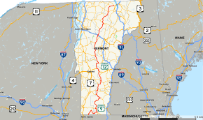
Vermont Route 100 (VT 100) is a north–south state highway in Vermont in the United States. Running through the center of the state, it travels nearly the entire length of Vermont and is 216.59 miles (349 km) long. VT 100 is the state's longest state highway, the longest north-south route in Vermont, and the longest numbered highway in Vermont of any type.
Route description
The southern terminus of the route is at the Massachusetts state line in Stamford, where it continues south as Route 8. Its northern terminus is at VT 105 in the town of Newport, which lies on the Canadian border. VT 100 passes along the eastern edge of the Green Mountain National Forest for much of its length and also passes through the Mad River Valley. It runs parallel to, and lies between, U.S. Route 7 (US 7) to the west and US 5 to the east.
The road is the main thoroughfare for some of Vermont's most well-known resort towns, including Wilmington, Ludlow, Killington, Warren, and Stowe. As such, many of Vermont's ski resorts are located either directly on, or in proximity to, VT 100; these include Okemo Mountain Resort, Mount Snow, Killington, Sugarbush, Mad River Glen, Stowe Mountain Resort and Jay Peak.
VT 100 is a popular tourist route during the fall (for foliage) and winter (for skiing), and can be heavily trafficked during those seasons. Despite this, the road retains a rural feel through most of the towns it traverses and is relatively free of development, except for some of the areas around the ski resorts. The most populous town through which VT 100 passes is Morristown, with a population of just over 5,200.
Several of the most heavily traveled sections of VT 100 (such as the section between Waterbury and Stowe and Warren to Waitsfield) were in very poor condition due to state and local road maintenance budget shortfalls, recent harsh winters and heavy damage by Tropical Storm Irene; since that storm, the state has undertaken the reconstruction of many segments of the road.
Major intersections
| County | Location | mi[1] | km | Destinations | Notes |
|---|---|---|---|---|---|
| Bennington | Stamford | 0.000 | 0.000 | Continuation of Route 8 from Massachusetts Southern terminus of VT 8 and its concurrency with VT 100 | |
| Readsboro | 7.945 | 12.786 | Northern end of concurrency with VT 8 | ||
| Windham | Jacksonville | 21.428 | 34.485 | Northern terminus of VT 112 | |
| Wilmington | 26.989 | 43.435 | Southern end of concurrency with VT 9 | ||
| 28.059 | 45.157 | Northern end of concurrency with VT 9 | |||
| Jamaica | 50.742 | 81.661 | Southern end of concurrency with VT 30 | ||
| 58.878 | 94.755 | Northern end of concurrency with VT 30 | |||
| Londonderry | 65.655 | 105.661 | Southern end of concurrency with VT 11 | ||
| 66.069 | 106.328 | Northern end of concurrency with VT 11 | |||
| Windsor | Weston | 74.455 | 119.824 | Southern terminus of VT 155 | |
| Village of Ludlow | 81.548 | 131.239 | Southern end of concurrency with VT 103 | ||
| Town of Ludlow | 83.382 | 134.190 | Northern end of concurrency with VT 103 | ||
| Plymouth | 92.112 | 148.240 | Southern terminus of VT 100A | ||
| Bridgewater | 97.505 | 156.919 | Southern end of concurrency with US 4 | ||
| Rutland | Killington | 103.942 | 167.278 | Northern end of concurrency with US 4 | |
| Windsor | Stockbridge | 114.655 | 184.519 | Western terminus of VT 107 | |
| Rochester | 122.354 | 196.910 | Eastern terminus of VT 73 | ||
| Addison | Hancock | 127.432 | 205.082 | Eastern terminus of VT 125 | |
| Washington | Waitsfield | 147.370 | 237.169 | Eastern terminus of VT 17 | |
| Moretown | 152.821 | 245.942 | Southern terminus of VT 100B | ||
| 159.827 | 257.217 | Southern end of concurrency with US 2 | |||
| Waterbury | 161.142 | 259.333 | Northern end of concurrency with US 2 | ||
| 161.299– 161.660 | 259.586– 260.167 | Exit 10 on I-89 | |||
| Lamoille | Stowe | 171.212 | 275.539 | Southern terminus of VT 108 | |
| Morrisville | 180.063 | 289.783 | Western terminus of VT 15A | ||
| Morristown | 181.305 | 291.782 | Southern end of concurrency with VT 15 | ||
| Village of Hyde Park | 183.236 | 294.890 | Northern end of concurrency with VT 15 | ||
| Town of Hyde Park | 188.374 | 303.159 | Northern terminus of VT 100C | ||
| Eden | 192.652 | 310.043 | Southern terminus of VT 118 | ||
| Orleans | Lowell | 201.826 | 324.807 | ||
| Troy | 209.797 | 337.636 | Southern terminus of VT 101 | ||
| Town of Newport | 215.828 | 347.341 | Northern terminus of VT 14 | ||
| 216.666 | 348.690 | ||||
1.000 mi = 1.609 km; 1.000 km = 0.621 mi
| |||||
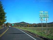
Suffixed routes
VT 100A
| |
|---|---|
| Location: | Plymouth–Bridgewater |
| Length: | 6.971 mi[1] (11.219 km) |
Vermont Route 100A (VT 100A) is a short auxiliary route of VT 100 in Bridgewater. It is about seven miles (11 km) long and it connects VT 100 to U.S. Route 4. The route generally runs in a northeast–southwest direction.
VT 100B
| |
|---|---|
| Location: | Moretown–Middlesex |
| Length: | 7.922 mi[1] (12.749 km) |
Vermont Route 100B (VT 100B) is a spur route that branches off of VT 100 in Moretown. The designation is about eight miles (13 km) long. The route, which runs in a northeast–southwest direction, connects VT 100 to U.S. Route 2 in Middlesex.
VT 100C
| |
|---|---|
| Location: | Johnson–Hyde Park |
| Length: | 4.595 mi[1] (7.395 km) |
Vermont Route 100C (VT 100C) is a spur route of VT 100 that begins in Hyde Park and runs southwest to an intersection with VT 15 in Johnson. It is about 4.6 miles (7.4 km) long.
References
- 1 2 3 4 5 Traffic Research Unit (May 2013). "2012 (Route Log) AADTs for State Highways" (PDF). Policy, Planning and Intermodal Development Division, Vermont Agency of Transportation. Retrieved March 17, 2015.