Walker, Iowa
| Walker, Iowa | |
|---|---|
| City | |
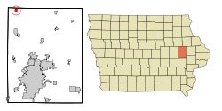 Location of Walker, Iowa | |
| Coordinates: 42°17′14″N 91°46′53″W / 42.28722°N 91.78139°WCoordinates: 42°17′14″N 91°46′53″W / 42.28722°N 91.78139°W | |
| Country |
|
| State |
|
| County | Linn |
| Area[1] | |
| • Total | 0.77 sq mi (1.99 km2) |
| • Land | 0.76 sq mi (1.97 km2) |
| • Water | 0.01 sq mi (0.03 km2) |
| Elevation | 899 ft (274 m) |
| Population (2010)[2] | |
| • Total | 791 |
| • Estimate (2012[3]) | 797 |
| • Density | 1,040.8/sq mi (401.9/km2) |
| Time zone | Central (CST) (UTC-6) |
| • Summer (DST) | CDT (UTC-5) |
| ZIP code | 52352 |
| Area code(s) | 319 |
| FIPS code | 19-81885 |
| GNIS feature ID | 0462608 |
Walker is a city in Linn County, Iowa, United States. The population was 791 at the 2010 census. It is part of the Cedar Rapids Metropolitan Statistical Area.
Near Walker, there are several guy-wired TV towers, all of them nearly 2000 feet tall.
History
Walker began as an outgrowth of the Burlington, Cedar Rapids and Northern Railway. It was named in honor of W. W. Walker, chief engineer of the railroad.[4]
Geography
Walker is located at 42°17′14″N 91°46′53″W / 42.28722°N 91.78139°W (42.287342, -91.781400).[5]
According to the United States Census Bureau, the city has a total area of 0.77 square miles (1.99 km2), of which, 0.76 square miles (1.97 km2) is land and 0.01 square miles (0.03 km2) is water.[1]
Demographics
| Historical populations | ||
|---|---|---|
| Year | Pop. | ±% |
| 1900 | 505 | — |
| 1910 | 517 | +2.4% |
| 1920 | 464 | −10.3% |
| 1930 | 456 | −1.7% |
| 1940 | 462 | +1.3% |
| 1950 | 549 | +18.8% |
| 1960 | 584 | +6.4% |
| 1970 | 622 | +6.5% |
| 1980 | 733 | +17.8% |
| 1990 | 673 | −8.2% |
| 2000 | 750 | +11.4% |
| 2010 | 791 | +5.5% |
| 2014 | 792 | +0.1% |
| 2015 | 792 | +0.0% |
| Source:"American FactFinder". United States Census Bureau. and Iowa Data Center Source: | ||
2010 census
As of the census[2] of 2010, there were 791 people, 289 households, and 215 families residing in the city. The population density was 1,040.8 inhabitants per square mile (401.9/km2). There were 309 housing units at an average density of 406.6 per square mile (157.0/km2). The racial makeup of the city was 98.0% White, 0.3% African American, 0.4% Native American, 0.1% from other races, and 1.3% from two or more races. Hispanic or Latino of any race were 1.0% of the population.
There were 289 households of which 41.5% had children under the age of 18 living with them, 59.9% were married couples living together, 9.7% had a female householder with no husband present, 4.8% had a male householder with no wife present, and 25.6% were non-families. 21.1% of all households were made up of individuals and 12.5% had someone living alone who was 65 years of age or older. The average household size was 2.74 and the average family size was 3.18.
The median age in the city was 34 years. 32.2% of residents were under the age of 18; 6.4% were between the ages of 18 and 24; 26.5% were from 25 to 44; 22.4% were from 45 to 64; and 12.6% were 65 years of age or older. The gender makeup of the city was 48.5% male and 51.5% female.
2000 census
As of the census[7] of 2000, there were 750 people, 273 households, and 197 families residing in the city. The population density was 1,066.1 people per square mile (413.7/km²). There were 286 housing units at an average density of 406.6 per square mile (157.8/km²). The racial makeup of the city was 98.67% White, 0.27% African American, 0.53% Native American, and 0.53% from two or more races.
There were 273 households out of which 40.3% had children under the age of 18 living with them, 62.6% were married couples living together, 7.3% had a female householder with no husband present, and 27.5% were non-families. 22.7% of all households were made up of individuals and 13.2% had someone living alone who was 65 years of age or older. The average household size was 2.75 and the average family size was 3.23.
30.7% were under the age of 18, 8.5% from 18 to 24, 30.3% from 25 to 44, 18.7% from 45 to 64, and 11.9% were 65 years of age or older. The median age was 33 years. For every 100 females there were 94.3 males. For every 100 females age 18 and over, there were 86.4 males.
The median income for a household in the city was $43,438, and the median income for a family was $50,556. Males had a median income of $34,271 versus $23,618 for females. The per capita income for the city was $16,258. About 4.1% of families and 5.2% of the population were below the poverty line, including 6.6% of those under age 18 and 8.5% of those age 65 or over.
Education
Just north of Walker is Cono Christian School, an international boarding school, founded by Max Belz in 1948.
References
- 1 2 "US Gazetteer files 2010". United States Census Bureau. Retrieved 2012-05-11.
- 1 2 "American FactFinder". United States Census Bureau. Retrieved 2012-05-11.
- ↑ "Population Estimates". United States Census Bureau. Retrieved 2013-05-23.
- ↑ The History of Linn County, Iowa: Containing a History of the County, Its Cities, Towns, &c. Western Historical Company. 1878. p. 600.
- ↑ "US Gazetteer files: 2010, 2000, and 1990". United States Census Bureau. 2011-02-12. Retrieved 2011-04-23.
- ↑ "Census of Population and Housing". Census.gov. Retrieved June 4, 2015.
- ↑ "American FactFinder". United States Census Bureau. Retrieved 2008-01-31.
Municipalities and communities of Linn County, Iowa, United States | ||
|---|---|---|
| Cities | ||
| Townships | ||
| Unincorporated communities | ||
| Footnotes | ‡This populated place also has portions in an adjacent county or counties | |