Wasta, South Dakota
| Wasta, South Dakota wašté | |
|---|---|
| Town | |
|
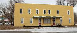
The Wasta Hotel, located at Ash and B streets in Wasta. The hotel is listed on the National Register of Historic Places. | |
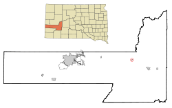 Location in Pennington County and the state of South Dakota | |
| Coordinates: 44°4′7″N 102°26′42″W / 44.06861°N 102.44500°WCoordinates: 44°4′7″N 102°26′42″W / 44.06861°N 102.44500°W | |
| Country | United States |
| State | South Dakota |
| County | Pennington |
| Incorporated | 1930[1] |
| Area[2] | |
| • Total | 0.19 sq mi (0.49 km2) |
| • Land | 0.19 sq mi (0.49 km2) |
| • Water | 0 sq mi (0 km2) |
| Elevation | 2,320 ft (707 m) |
| Population (2010)[3] | |
| • Total | 80 |
| • Estimate (2012[4]) | 81 |
| • Density | 421.1/sq mi (162.6/km2) |
| Time zone | Mountain (MST) (UTC-7) |
| • Summer (DST) | MDT (UTC-6) |
| ZIP codes | 57767, 57791 |
| Area code(s) | 605 |
| FIPS code | 46-69140[5] |
| GNIS feature ID | 1258837[6] |
Wasta (Lakota: 'wašté') is a town in Pennington County, South Dakota, United States along the Cheyenne River. The population was 80 at the 2010 census.
History
A post office called Wasta has been in operation since 1907.[7] Wasta is a name derived from the Dakota word "wašté", meaning "good".[8][9]
Geography
Wasta is located at 44°4′7″N 102°26′42″W / 44.06861°N 102.44500°W (44.068638, -102.445108).[10]
According to the United States Census Bureau, the town has a total area of 0.19 square miles (0.49 km2), all of it land.[2]
Wasta has been assigned the ZIP code 57791 and the FIPS place code 69140.
Climate
| Month | Jan | Feb | Mar | Apr | May | Jun | Jul | Aug | Sep | Oct | Nov | Dec | Year |
|---|---|---|---|---|---|---|---|---|---|---|---|---|---|
| Record high °F (°C) | 73 (23) |
77 (25) |
86 (30) |
97 (36) |
102 (39) |
111 (44) |
111 (44) |
109 (43) |
107 (42) |
98 (37) |
86 (30) |
72 (22) |
111 (44) |
| Average high °F (°C) | 36 (2) |
40 (4) |
50 (10) |
61 (16) |
71 (22) |
81 (27) |
89 (32) |
88 (31) |
78 (26) |
63 (17) |
48 (9) |
36 (2) |
61.8 (16.5) |
| Daily mean °F (°C) | 23 (−5) |
27 (−3) |
37 (3) |
47 (8) |
58 (14) |
68 (20) |
75 (24) |
74 (23) |
63 (17) |
49 (9) |
35 (2) |
23 (−5) |
48.3 (8.9) |
| Average low °F (°C) | 10 (−12) |
14 (−10) |
23 (−5) |
33 (1) |
45 (7) |
54 (12) |
61 (16) |
59 (15) |
47 (8) |
34 (1) |
21 (−6) |
10 (−12) |
34.3 (1.3) |
| Record low °F (°C) | −33 (−36) |
−38 (−39) |
−29 (−34) |
5 (−15) |
15 (−9) |
32 (0) |
38 (3) |
35 (2) |
19 (−7) |
−4 (−20) |
−25 (−32) |
−33 (−36) |
−38 (−39) |
| Average precipitation inches (mm) | 0.23 (5.8) |
0.50 (12.7) |
1.02 (25.9) |
1.77 (45) |
3.41 (86.6) |
2.66 (67.6) |
1.91 (48.5) |
1.61 (40.9) |
1.34 (34) |
1.58 (40.1) |
0.67 (17) |
0.39 (9.9) |
17.09 (434) |
| Source: The Weather Channel[11] | |||||||||||||
Demographics
| Historical population | |||
|---|---|---|---|
| Census | Pop. | %± | |
| 1940 | 153 | — | |
| 1950 | 144 | −5.9% | |
| 1960 | 196 | 36.1% | |
| 1970 | 127 | −35.2% | |
| 1980 | 99 | −22.0% | |
| 1990 | 82 | −17.2% | |
| 2000 | 75 | −8.5% | |
| 2010 | 80 | 6.7% | |
| Est. 2015 | 82 | [12] | 2.5% |
2010 census
As of the census[3] of 2010, there were 80 people, 36 households, and 20 families residing in the town. The population density was 421.1 inhabitants per square mile (162.6/km2). There were 46 housing units at an average density of 242.1 per square mile (93.5/km2). The racial makeup of the town was 100.0% White. Hispanic or Latino of any race were 1.3% of the population.
There were 36 households of which 25.0% had children under the age of 18 living with them, 44.4% were married couples living together, 11.1% had a female householder with no husband present, and 44.4% were non-families. 33.3% of all households were made up of individuals and 11.1% had someone living alone who was 65 years of age or older. The average household size was 2.22 and the average family size was 2.90.
The median age in the town was 40.5 years. 22.5% of residents were under the age of 18; 11.3% were between the ages of 18 and 24; 22.6% were from 25 to 44; 22.6% were from 45 to 64; and 21.3% were 65 years of age or older. The gender makeup of the town was 52.5% male and 47.5% female.
2000 census
As of the census[5] of 2000, there were 75 people, 35 households, and 19 families residing in the town. The population density was 390.7 people per square mile (152.4/km²). There were 46 housing units at an average density of 239.6 per square mile (93.5/km²). The racial makeup of the town was 98.67% White and 1.33% Asian. Hispanic or Latino of any race were 1.33% of the population.
There were 35 households out of which 25.7% had children under the age of 18 living with them, 42.9% were married couples living together, 2.9% had a female householder with no husband present, and 45.7% were non-families. 37.1% of all households were made up of individuals and 17.1% had someone living alone who was 65 years of age or older. The average household size was 2.14 and the average family size was 2.63.
In the town the population was spread out with 22.7% under the age of 18, 5.3% from 18 to 24, 28.0% from 25 to 44, 21.3% from 45 to 64, and 22.7% who were 65 years of age or older. The median age was 38 years. For every 100 females there were 108.3 males. For every 100 females age 18 and over, there were 123.1 males.
The median income for a household in the town was $26,375, and the median income for a family was $26,250. Males had a median income of $30,000 versus $25,000 for females. The per capita income for the town was $13,888. There were 17.6% of families and 15.7% of the population living below the poverty line, including 38.1% of under eighteens and none of those over 64.
Filming Location
The Redwood Motel in Wasta was used extensively as a filming site for the movie Thunderheart .
References
- ↑ "SD Towns" (PDF). South Dakota State Historical Society. Retrieved 2010-02-17.
- 1 2 "US Gazetteer files 2010". United States Census Bureau. Retrieved 2012-06-21.
- 1 2 "American FactFinder". United States Census Bureau. Retrieved 2012-06-21.
- ↑ "Population Estimates". United States Census Bureau. Retrieved 2013-05-29.
- 1 2 "American FactFinder". United States Census Bureau. Retrieved 2008-01-31.
- ↑ "US Board on Geographic Names". United States Geological Survey. 2007-10-25. Retrieved 2008-01-31.
- ↑ "Pennington County". Jim Forte Postal History. Retrieved 31 March 2015.
- ↑ Chicago and North Western Railway Company (1908). A History of the Origin of the Place Names Connected with the Chicago & North Western and Chicago, St. Paul, Minneapolis & Omaha Railways. p. 135.
- ↑ Ullrich, Jan F. (2014). New Lakota Dictionary (2nd ed.). Bloomington, IN: Lakota Language Consortium. ISBN 978-0-9761082-9-0.
- ↑ "US Gazetteer files: 2010, 2000, and 1990". United States Census Bureau. 2011-02-12. Retrieved 2011-04-23.
- ↑ "Monthly Averages for Wasta, SD". The Weather Channel. Retrieved June 4, 2014.
- ↑ "Annual Estimates of the Resident Population for Incorporated Places: April 1, 2010 to July 1, 2015". Retrieved July 2, 2016.
- ↑ "Census of Population and Housing". Census.gov. Retrieved June 4, 2015.
Municipalities and communities of Pennington County, South Dakota, United States | ||
|---|---|---|
| Cities |  | |
| Towns | ||
| CDPs | ||
| Other unincorporated communities | ||
| Ghost towns | ||
| Footnotes | ‡This populated place also has portions in an adjacent county or counties | |