Watkins Glen, New York
| Watkins Glen, New York | |
|---|---|
| Village | |
 Watkins Glen, New York Location within the state of New York | |
| Coordinates: 42°22′52″N 76°52′16″W / 42.38111°N 76.87111°WCoordinates: 42°22′52″N 76°52′16″W / 42.38111°N 76.87111°W | |
| Country | United States |
| State | New York |
| County | Schuyler |
| Area | |
| • Total | 2.2 sq mi (5.8 km2) |
| • Land | 1.9 sq mi (4.8 km2) |
| • Water | 0.4 sq mi (1.0 km2) |
| Elevation | 463 ft (141 m) |
| Population (2000) | |
| • Total | 1,859 |
| • Density | 845/sq mi (326.25/km2) |
| Time zone | Eastern (EST) (UTC-5) |
| • Summer (DST) | EDT (UTC-4) |
| ZIP code | 14891 |
| Area code(s) | 607 |
| FIPS code | 36-78696[1] |
| GNIS feature ID | 0974082[2] |
Watkins Glen is a village in Schuyler County, New York, United States. The population was 1,859 at the 2010 census. It is the county seat of Schuyler County.[3] The Village of Watkins Glen lies within the towns of Dix and Reading.
History
The first settlement of European peoples in the area began circa 1800. Watkins Glen was the northern terminus of the Chemung Canal, started in 1830 and completed in 1833, connecting Seneca Lake to the Chemung River. Catharine Creek, flowing into the lake through the village, was used to help create the canal. The village was incorporated in 1842 as Salubria, then Jefferson, but was renamed Watkins after Dr. Samuel Watkins, for his contributions to the community. The current name Watkins Glen was adopted in 1926.
For the first half of the 20th century, the village was primarily known as the site of Glen Springs Sanitarium, one of the leading spas in the United States.
In 2006 Charles R. Mitchell and Kirk W. House produced a historic photo book, Around Watkins Glen, in the Arcadia Publishing "Images of America" series.
The A. F. Chapman House, First Baptist Church of Watkins Glen, Schuyler County Courthouse Complex, St. James Episcopal Church, United States Post Office, Watkins Glen Commercial Historic District, Watkins Glen Grand Prix Course, 1948-1952, and Watkins Glen High School are listed on the National Register of Historic Places.[4][5][6]
Geography
Watkins Glen is located at 42°22′52″N 76°52′16″W / 42.38111°N 76.87111°W (42.380984, -76.871079).[7]
According to the United States Census Bureau, the village has a total area of 2.2 square miles (5.7 km2). 1.9 square miles (4.9 km2) of the village is land and 0.4 square miles (1.0 km2) of it (17.41%) is water.
New York State Route 14 joins New York State Route 79 and New York State Route 414 by Watkins Glen. NY-14 is one of the principal streets in Watkins Glen village. New York State Route 329 and New York State Route 409 lead into Watkins Glen from the west.
Demographics
| Historical population | |||
|---|---|---|---|
| Census | Pop. | %± | |
| 1870 | 2,039 | — | |
| 1880 | 2,716 | 33.2% | |
| 1890 | 2,604 | −4.1% | |
| 1900 | 2,943 | 13.0% | |
| 1910 | 2,817 | −4.3% | |
| 1920 | 2,785 | −1.1% | |
| 1930 | 2,956 | 6.1% | |
| 1940 | 2,913 | −1.5% | |
| 1950 | 3,052 | 4.8% | |
| 1960 | 2,813 | −7.8% | |
| 1970 | 2,716 | −3.4% | |
| 1980 | 2,440 | −10.2% | |
| 1990 | 2,207 | −9.5% | |
| 2000 | 2,149 | −2.6% | |
| 2010 | 1,859 | −13.5% | |
| Est. 2015 | 1,859 | [8] | 0.0% |
As of the census[1] of 2010, there were 1,859 people, 873 households, and 442 families residing in the village. The population density was 845 per square mile (326.25/km²). There were 977 housing units at an average density of 444 per square mile (168.4/km²). The racial makeup of the village was 96.2% White, 0.50% African American, 0.40% Native American, 0.50% Asian, 0.70% from other races, and 1.70% from two or more races. Hispanic or Latino of any race were 1.40% of the population.
There were 873 households out of which 22.60% had children under the age of 18 living with them, 33.70% were married couples living together, 12.7% had a female householder with no husband present, and 49.40% were non-families. 42.40% of all households were made up of individuals. The average household size was 2.09 and the average family size was 2.86.
In the village the age distribution of the population was spread out with 22.70% under the age of 20, 5.40% from 20 to 24, and 31.80% from 25 to 50 and 17.50% who were 65 years of age or older. The median age was 43.20 years old. The Village of Watkins Glen had 866 male residents, and 993 female residents.
The median income for a household in the village was $34,969 and the median income for a family was $55,357. Males had a median income of $37,885 versus $29,000 for females. The per capita income for the village was $24,116. 5.0% of the population and 1.70% of families were living below the poverty line. 3.6% of those under the age of 18 and 6.80% of those 65 and older were living below the poverty line.
Notable events and attractions
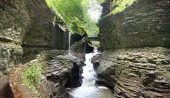
Located on the southern tip of Seneca Lake, one of western New York's deep, glacial Finger Lakes, Watkins Glen is the site of scenic Watkins Glen State Park. The town is noted for its role in auto racing, being the home of a street course used in road racing, a famous racetrack, Watkins Glen International, which has hosted the NASCAR Cup Series Cheez-It 355 at The Glen, IndyCar Series Grand Prix at The Glen, and the IMSA SportsCar Championship 6 Hours of Watkins Glen.
The racetrack was also the scene of the 1973 Summer Jam at Watkins Glen rock festival attended by an estimated 600,000 people, nearly twice the crowd at 1969's historic Woodstock Festival and a world record for the largest number of people at a pop music festival. The concert featured The Allman Brothers Band, the The Grateful Dead, and The Band. On July 1–3 of 2011, the band Phish hosted Superball IX, a three-day music festival on the same grounds of the Summer Jam of '73.
Watkins Glen is also the home port for True Love, an 84-plus-year-old schooner that has been featured in several Hollywood movies, including High Society (1956) and The Philadelphia Story (1940).
The International Motor Racing Research Center,[10] an annex to the village library, is located in Watkins Glen.
Auto racing at Watkins Glen
Watkins Glen is home to Watkins Glen International, one of the premier automobile road racing tracks in the United States. The first Watkins Glen Sports Car Grand Prix, however, was held in 1948 on public streets in and near the village. Organized by local resident Cameron Argetsinger, it was the first post-WWII road race held in the United States and it marked the revival of American road racing.
The original course ran for 6.6 miles (10.6 km) and passed through the center of the village. The streets used for the original course remain intact today and a checkered flag marks the original start-finish line on the village's main street.
A permanent racing facility, the Watkins Glen Grand Prix Race Course opened in 1956. It has hosted nearly every type of road racing, from the Sahlen's 6 Hours of Watkins Glen (1948-current), the Formula One United States Grand Prix (1961–1980), and the Cheez-It 355 at The Glen (1957-current), one of the few races on the NASCAR Sprint Cup Series schedule not conducted on an oval speedway, the other being Sonoma Raceway.
References
Notes
- 1 2 "American FactFinder". United States Census Bureau. Retrieved 2008-01-31.
- ↑ "US Board on Geographic Names". United States Geological Survey. 2007-10-25. Retrieved 2008-01-31.
- ↑ "Find a County". National Association of Counties. Retrieved 2011-06-07.
- ↑ National Park Service (2009-03-13). "National Register Information System". National Register of Historic Places. National Park Service.
- ↑ "National Register of Historic Places". Weekly List of Actions Taken on Properties: 11/19/12 through 11/23/12. National Park Service. 2012-11-30.
- ↑ "National Register of Historic Places". Weekly List of Actions Taken on Properties: 2/09/15 through 2/13/15. National Park Service. 2015-02-20.
- ↑ "US Gazetteer files: 2010, 2000, and 1990". United States Census Bureau. 2011-02-12. Retrieved 2011-04-23.
- ↑ "Annual Estimates of the Resident Population for Incorporated Places: April 1, 2010 to July 1, 2015". Retrieved July 2, 2016.
- ↑ "Census of Population and Housing". Census.gov. Retrieved June 4, 2015.
- ↑ http://www.racingarchives.org/ International Motor Racing Research Center
External links
- Village of Watkins Glen
- Watkins Glen State Park
- Book excerpt on the 1973 Summer Jam Rock Festival from "AQUARIUS RISING" by Robert Santelli
- 1884 Guidebook to Watkins Glen with Illustrations at Internet Archive
- Google Earth overlay of original circuit
Municipalities and communities of Schuyler County, New York, United States | ||
|---|---|---|
| Towns | 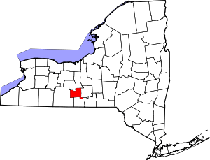 | |
| Villages | ||