Wayra Wasi
For the mountain at the border of the Potosí Municipality and the Yocalla Municipality, Tomás Frías Province, Potosí Department, Bolivia, see Wayra Wasi (Potosí-Yocalla).
| Wayra Wasi | |
|---|---|
 Wayra Wasi Location in Bolivia | |
| Highest point | |
| Elevation | 4,416 m (14,488 ft) [1] |
| Coordinates | 19°23′33″S 65°38′45″W / 19.39250°S 65.64583°WCoordinates: 19°23′33″S 65°38′45″W / 19.39250°S 65.64583°W |
| Geography | |
| Location |
Bolivia, Potosí Department |
| Parent range | Andes |
Wayra Wasi (Quechua wayra wind, wasi house, [2] "wind house", hispanicized spelling Huayra Huasi) is a 4,416-metre (14,488 ft) high mountain in the Bolivian Andes. It is situated in the Potosí Department, Tomás Frías Province, Potosí Municipality. Wayra Wasi lies west of Jatun Q'asa and the Ch'aki Mayu (Quechua for "dry river", Chaqui Mayu). The river originates southeast of the mountain. It flows to the north.[1][3]
References
Capital: Potosí | ||
| Provinces | 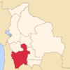 | |
| Municipalities (and seats) |
| |
This article is issued from Wikipedia - version of the 5/5/2016. The text is available under the Creative Commons Attribution/Share Alike but additional terms may apply for the media files.