Wedowee, Alabama
| Wedowee, Alabama | |
|---|---|
| Town | |
 | |
 Location in Randolph County and the state of Alabama | |
| Coordinates: 33°18′31″N 85°29′8″W / 33.30861°N 85.48556°W | |
| Country | United States |
| State | Alabama |
| County | Randolph |
| Area | |
| • Total | 3.5 sq mi (9.2 km2) |
| • Land | 3.5 sq mi (9.1 km2) |
| • Water | 0 sq mi (0.1 km2) |
| Elevation | 856 ft (261 m) |
| Population (2010) | |
| • Total | 823 |
| • Density | 233.7/sq mi (88.9/km2) |
| Time zone | Central (CST) (UTC-6) |
| • Summer (DST) | CDT (UTC-5) |
| ZIP code | 36278 |
| Area code(s) | 256 |
| FIPS code | 01-80496 |
| GNIS feature ID | 0153913 |
Wedowee is a town in Randolph County, Alabama, United States. At the 2010 census the population was 823, up from 818 in 2000. The city is the county seat of Randolph County.[1] It was initially incorporated in 1836, but its charter lapsed by the late 19th century. It was reincorporated in 1901.[2]
Randolph County High School is located in Wedowee.
History
Wedowee, which means "old water" in the Creek language, was named after a Muscogee Creek Indian chief. This area was historically occupied by the Muscogee Creek people.
Following Indian Removal of the Creek in the 1830s to Indian Territory in a relocation forced by the US government, this area was settled by European Americans. It became the county seat of Randolph County in 1835. The county was developed for the cultivation of cotton as a commodity crop, with labor primarily done by enslaved African Americans, many of whom were sold to the Deep South from the Upper South.
Since the late 20th century, Lake Wedowee was created by the impoundment of the Tallapoosa River. This has enhanced the tourist drawing power of the town. Also known as the R. L. Harris Reservoir, the lake draws thousands of visitors to Wedowee every year. [3]
Geography
Wedowee is located on the Piedmont Plateau and considered part of the Appalachians foothills.
Wedowee is located at 33°18′31″N 85°29′8″W / 33.30861°N 85.48556°W (33.308603, -85.485447).[4]
According to the U.S. Census Bureau, the town has a total area of 3.5 square miles (9.1 km2), of which 3.5 square miles (9.1 km2) is land and 0.04 square miles (0.10 km2) (0.85%) is water.
Demographics
| Historical population | |||
|---|---|---|---|
| Census | Pop. | %± | |
| 1870 | 130 | — | |
| 1910 | 435 | — | |
| 1920 | 510 | 17.2% | |
| 1930 | 396 | −22.4% | |
| 1940 | 525 | 32.6% | |
| 1950 | 559 | 6.5% | |
| 1960 | 917 | 64.0% | |
| 1970 | 842 | −8.2% | |
| 1980 | 908 | 7.8% | |
| 1990 | 796 | −12.3% | |
| 2000 | 818 | 2.8% | |
| 2010 | 823 | 0.6% | |
| Est. 2015 | 809 | [5] | −1.7% |
| U.S. Decennial Census[6] 2013 Estimate[7] | |||
As of the census[8] of 2000, there were 818 people, 337 households, and 200 families residing in the town. The population density was 233.4 people per square mile (90.0/km²). There were 378 housing units at an average density of 107.8 per square mile (41.6/km²). The racial makeup of the town was 68.70% White, 30.20% Black or African American, 0.12% Native American, 0.49% Asian, 0.24% from other races, and 0.24% from two or more races. 0.12% of the population were Hispanic or Latino of any race.
There were 337 households out of which 26.1% had children under the age of 18 living with them, 43.0% were married couples living together, 13.6% had a female householder with no husband present, and 40.4% were non-families. 36.5% of all households were made up of individuals and 22.0% had someone living alone who was 65 years of age or older. The average household size was 2.23 and the average family size was 2.95.
In the town the population was spread out with 21.8% under the age of 18, 8.9% from 18 to 24, 27.4% from 25 to 44, 21.6% from 45 to 64, and 20.3% who were 65 years of age or older. The median age was 39 years. For every 100 females there were 97.6 males. For every 100 females age 18 and over, there were 95.1 males.
The median income for a household in the town was $26,136, and the median income for a family was $37,292. Males had a median income of $24,250 versus $22,250 for females. The per capita income for the town was $12,638. About 17.1% of families and 20.9% of the population were below the poverty line, including 25.7% of those under age 18 and 21.4% of those age 65 or over.
Notable people
- Hulond Humphries - A part-time hog farmer, former high-school principal and district superintendent who caused a number of controversies in the 1990s as a result of his opposition to interracial dating.
- T. Jack Lee, sixth Director of the NASA Marshall Space Flight Center in Huntsville, Alabama, from July 6, 1989 to January 6, 1994
- Stanley O'Neal - A former CEO of Merrill Lynch and currently on the board of Alcoa.
- William Hugh Smith - 21st Governor of Alabama (In office: 1868-1870). Serving during the Reconstruction era, Smith was the first Republican Governor of Alabama. Smith moved with his parents to Wedowee in 1839, at the age of 13. He read law under John T. Heflin of Wedowee.[9] A historic marker now stands on the site of his family's home along N. Main Street (U.S. Route 431) in Wedowee.
- Alvin Wright - former NFL defensive lineman
Gallery
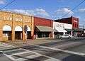 Downtown Wedowee
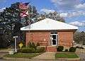 Wedowee City Hall
 The Randolph County Courthouse is located in Wedowee.
 A historic marker which describes the early history of Randolph County is located on the grounds of the Randolph County Courthouse in Wedowee.
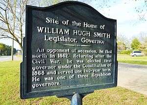 This historic marker marks the site of the home of William Hugh Smith, 21st Governor of Alabama (1868-1870).
References
- ↑ "Find a County". National Association of Counties. Retrieved 2011-06-07.
- ↑ http://www2.census.gov/prod2/decennial/documents/41033935v1-8ch1.pdf
- ↑ Small Town Historic Markers, Alabama Tourism Department, retrieved 2011-02-02
- ↑ "US Gazetteer files: 2010, 2000, and 1990". United States Census Bureau. 2011-02-12. Retrieved 2011-04-23.
- ↑ "Annual Estimates of the Resident Population for Incorporated Places: April 1, 2010 to July 1, 2015". Retrieved July 2, 2016.
- ↑ "U.S. Decennial Census". Census.gov. Retrieved June 6, 2013.
- ↑ "Annual Estimates of the Resident Population: April 1, 2010 to July 1, 2013". Retrieved June 3, 2014.
- ↑ "American FactFinder". United States Census Bureau. Retrieved 2008-01-31.
- ↑ Alabama Governors -- William Hugh Smith, Alabama Department of Archives and History, retrieved 2011-03-24
External links
Coordinates: 33°18′31″N 85°29′08″W / 33.308603°N 85.485447°W
Municipalities and communities of Randolph County, Alabama, United States | ||
|---|---|---|
| City |  | |
| Towns | ||
| CDPs | ||
| Unincorporated communities | ||