Welshfield, Ohio
| Welshfield, Ohio | |
|---|---|
| Unincorporated community | |
 Location of Welshfield, Ohio | |
| Coordinates: 41°23′13″N 81°8′32″W / 41.38694°N 81.14222°WCoordinates: 41°23′13″N 81°8′32″W / 41.38694°N 81.14222°W | |
| Country | United States |
| State | Ohio |
| County | Geauga |
| Township | Troy |
| Elevation | 1,234 ft (376 m) |
| Time zone | Eastern (EST) (UTC-5) |
| • Summer (DST) | EDT (UTC-4) |
| GNIS feature ID | 1061727[1] |
Welshfield (also Troy, Troy Center, Troy Centre, or Wellsfield) is an unincorporated community in central Troy Township, Geauga County, Ohio, United States. It lies at the intersection of U.S. Route 422 and State Route 700, 1 mi (1½ km) east of the Cuyahoga River and 3 mi (5 km) east of the LaDue Reservoir.[2] Its elevation is 1,234 feet (376 m).[1] The community once had a post office that was established on 23 February 1838. When it was discontinued on 30 December 1958, the Burton office began to handle mail for Welshfield addresses.[3] Welshfield was named for Jacob Welsh, a pioneer settler.[4] Jacob Welsh helped build a local church and school in exchange for the naming rights.[5]
References
- 1 2 "Welshfield, Ohio". Geographic Names Information System. United States Geological Survey. Retrieved 2008-03-24.
- ↑ DeLorme. Ohio Atlas & Gazetteer. 7th ed. Yarmouth: DeLorme, 2004, p. 42. ISBN 0-89933-281-1.
- ↑ Geographic Names Information System Feature Detail Report, Geographic Names Information System, 1992-08-17. Accessed 2008-03-24.
- ↑ History of Geauga and Lake Counties, Ohio: With Illustrations and Biographical Sketches of Its Pioneers and Most Prominent Men. Williams Brothers. 1878. p. 186.
- ↑ Overman, William Daniel (1958). Ohio Town Names. Akron, OH: Atlantic Press. p. 140.
Municipalities and communities of Geauga County, Ohio, United States | ||
|---|---|---|
| City | 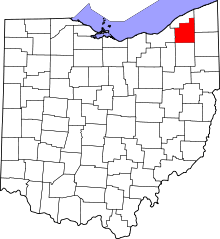 | |
| Villages | ||
| Townships | ||
| CDPs | ||
| Unincorporated communities | ||
| Footnotes | ‡This populated place also has portions in an adjacent county or counties | |
This article is issued from Wikipedia - version of the 10/29/2016. The text is available under the Creative Commons Attribution/Share Alike but additional terms may apply for the media files.