West Tyson County Park
| West Tyson County Park | |
| St. Louis County Park | |
| Country | United States |
|---|---|
| State | Missouri |
| County | St. Louis County |
| Coordinates | 38°31′07″N 90°35′04″W / 38.518573°N 90.584357°WCoordinates: 38°31′07″N 90°35′04″W / 38.518573°N 90.584357°W |
| Area | 1.05 sq mi (2.72 km2) |
| Founded | 1955 |
 | |
| Website: West Tyson County Park | |
West Tyson County Park is a county park in the U.S. state of Missouri consisting of 673 acres (2.72 km2) located in St. Louis County east of the town of Eureka.[1] The park is located north of Interstate 44, west of Tyson Research Center, east of Route 66 State Park, and south and east of the Meramec River.
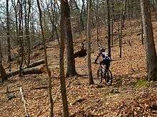
Mountain biker on the Rock Quarry Trail in West Tyson County Park
West Tyson County Park was originally part of the Tyson Valley Powder Plant during World War II. After the war 210 acres (0.85 km2) were acquired by St. Louis County in 1955. In 1979 an additional 410 acres (1.7 km2) were acquired. The Chubb Trail was developed in 1985. The William Epstein Memorial Prairie creation project was begun in 1988.[1]
References
- 1 2 "West Tyson". St. Louis County. Archived from the original on February 23, 2013. Retrieved July 22, 2012.
This article is issued from Wikipedia - version of the 11/9/2015. The text is available under the Creative Commons Attribution/Share Alike but additional terms may apply for the media files.