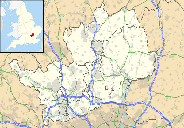
Widford, Hertfordshire
| Widford | |
 St John the Baptist Church |
|
 Widford |
|
| Population | 534 (2011)[1] |
|---|---|
| OS grid reference | TOL4215 |
| Civil parish | Widford |
| District | East Hertfordshire |
| Shire county | Hertfordshire |
| Region | East |
| Country | England |
| Sovereign state | United Kingdom |
| Post town | WARE |
| Postcode district | SG12 |
| Dialling code | 01279 |
| Police | Hertfordshire |
| Fire | Hertfordshire |
| Ambulance | East of England |
| EU Parliament | East of England |
| UK Parliament | Hertford and Stortford |
|
|
Coordinates: 51°49′19″N 0°03′36″E / 51.822°N 0.060°E
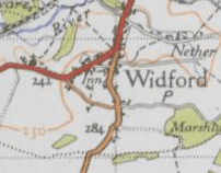
Widford is a village and civil parish located between Ware and Much Hadlam in the East Hertfordshire district of Hertfordshire in England. It covers an area of approximately 1,167 acres[2] and is made up of some 220 houses.[3] Widford is located South of the River Ash. Widford had a population of 534 people in the 2011 census.[4] The name Widford comes from the old English word 'wid' meaning willow tree and the word 'ford'[5]
Between the years of 1870 and 1872, John Marius Wilson described Widford as:
"a parish, with a village, in Ware district, Herts; near the Buntingford railway, 4 miles E by N of Ware. It has a post-office under Ware, and a r. station."[6]
History of Widford
The Widford commons were extensive and were enclosed under an award of 1856. There was a wood called Lily Wood located to the West of the village which was cut down in the late 19th century.[2]
Buildings in Widford
St John the Baptist Church
There is one church in Widford called St John the Baptist.[7] The oldest parts of the Church were built in the early parts of the 13th century and large amounts of work to the church were done later on in the 13th century and in the 14th century. Since then there have been numerous works of repair and renovation. The Church registers from 1558, access to these records is available at Hertfordshire County Record Office. There is a graveyard surrounding the church which was closed for burials in 1903 as a new graveyard on the other side of Ware Road became available. The Church is supported by an independent, non-religious charity called The Friends of Widford Church. The purpose of the charity is to support the Parochial Church council and to care for the management and maintenance of the church.[8]
Widford School
Widford School is a combination of a Primary school and a Pre-School. There are approximately 60 pupils in the school with a capacity for a maximum of 8 children per year group.[3] Widford School has been open since 1875.[9]
Village Hall
The Village Hall in Widford is located on Bell Lane in the South of the civil parish.[3] It was built more than 100 years ago in 1910 by George S Pawle. The primary use of the hall when it was first built was to be used as a drill hall for the Hertfordshire Regiment TA, in the 1st World War it was then used by a Regiment from Staffordshire. It was used as a village hall for village activities and events before it was bought in 1956 when volunteers raised money to buy the building and then renovate it. Since this occurred, volunteers have helped to care for the hall to maintain it, a new kitchen was implemented in 2009. The Village Hall has two main rooms, these are a large function room and then a smaller room. The large room has a removable stage and can hold an audience of 100 people. The smaller room is more of a committee room and can hold approximately 30 people. The village hall is available for hire by individuals and also local organisations.[10]
Demography

The population of Widford was first recorded in 1801 at 361. The population peaked in 1841 at 539.[11] In the most recent census in 2011 the population was measured as 534.[4]
Sport and Recreation
Widford Playing Field
Widford is home to Widford Playing Field, the leisure purposes of the playing field include a children's play area, a football pitch and also a cricket strip. The playing field has green areas as trees and hedges have been planted since its opening. The development of the playing field came after Askey's Field was purchased in 1979 by volunteers from the Village Hall Community who raised the money to allow them to purchase it.[3]
Ware Cricket Club
There is a cricket club in Widford named Ware Cricket Club. The ground is one of the few privately owned cricket grounds in the country.[3] The club has two teams that compete in the Saracens Hertfordshire Premier Cricket League.[12]
Public Houses

There was a point when there was five public houses in Widford, there is now just one. This is called the Green Man, this public house once experienced a scare that it would be closed but after a successful campaign by the local community it has remained open.[3]
People with links to Widford
- John Eliot was born in Widford. He was a Puritan missionary to the American Indians.[3] He developed an interest in Indian language and translated the Bible into Algonkian which is an American Indian, Algonquian language.[13]
- Arthur Ernest Percival who lived in Widford following the end of the Second World War, he was a British Army Officer who is best known for his involvement in the Second World War. He commanded the forces of the British Commonwealth during the Battle of Malaya and the subsequent Battle of Singapore.[3]
- The village also influenced writer Charles Lamb whose grandmother is buried on the parish. As children Lamb and his sister Mary often stayed at Blakesware (demolished 1830, replaced 1870's), near Widford, where Mary Field, their grandmother, was housekeeper to the Plumer family. Lamb recalled these visits in his essays 'Blakesmoor in H—shire' and 'Dream Children'.
Railway Station
There is a disused single platformed railway station in Widford, it was used between 1873 and 1963 as part of the Ware to Buntingford Branch Line. Construction of the railway began in 1859, four years later the line was complete and was nearly fourteen miles long. A coal and garden product distribution centre uses the site of the railway station. The railway line itself is used by walkers and cyclists.[14]
Employment

The data included in the graph shows that in 1881 there was one sector of employment that was significantly more popular than any others. This sector was the agriculture sector which had a total of 81 people working in.[11]
Allotment Gardens
There are allotment gardens in Widford with more than 20 plots available, these were created in 1978 after the land was purchased by Widford Parish Council.[3]
References
- ↑ "Civil Parish population 2011". Neighbourhood Statistics. Office for National Statistics. Retrieved 3 November 2016.
- 1 2 "British History Online". Parishes: Widford. University of London. Retrieved 17 March 2016.
- 1 2 3 4 5 6 7 8 9 "Widford Parish Council". Widford Village. Widford Parish Council. Retrieved 10 March 2016.
- 1 2 "Key Figures for 2011 Data: Widford". Neighbourhood Statistics. Office for National Statistics. Retrieved 28 January 2016.
- ↑ "University of Nottingham". Key to English Place-Names. University of Nottingham. Retrieved 24 April 2016.
- ↑ Wilson, John Marius (1870–72). Imperial Gazetteer of England and Wales. Edinburgh: A. Fullerton & Co.
- ↑ "A Church Near You". St John the Baptist, Widford. Archbishops' Council. Retrieved 10 March 2016.
- ↑ "Hunsdon with Widford and Wareside". The Church of St John the Baptist Widford, Hertfordshire. Retrieved 10 March 2016.
- ↑ "Widford School". Welcome to Widford School Website!. Retrieved 10 March 2016.
- ↑ "Widford Parish Council". Widford Village Hall. Widford Parish Council 2011–2015. Retrieved 17 March 2016.
- 1 2 "Vision of Britain". Widford AP/CP. Retrieved 24 April 2016.
- ↑ "Saracens Hertfordshire Premier Cricket League". Ware. Saracens Hertfordshire Premier Cricket League. Retrieved 10 March 2016.
- ↑ "Biographic sketches of memorable Christians of the Past". John Eliot, Missionary To the American Indians. Retrieved 19 March 2016.
- ↑ "Disused Stations". Station Name: WIDFORD. Disused Stations. Retrieved 17 March 2016.
External links
![]() Media related to Widford, Hertfordshire at Wikimedia Commons
Media related to Widford, Hertfordshire at Wikimedia Commons