Williams, Minnesota
| Williams, Minnesota | |
|---|---|
| City | |
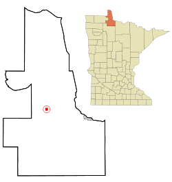 Location of Williams, Minnesota | |
| Coordinates: 48°46′7″N 94°57′16″W / 48.76861°N 94.95444°W | |
| Country | United States |
| State | Minnesota |
| County | Lake of the Woods |
| Area[1] | |
| • Total | 0.97 sq mi (2.51 km2) |
| • Land | 0.97 sq mi (2.51 km2) |
| • Water | 0 sq mi (0 km2) |
| Elevation | 1,152 ft (351 m) |
| Population (2010)[2] | |
| • Total | 191 |
| • Estimate (2012[3]) | 188 |
| • Density | 196.9/sq mi (76.0/km2) |
| Time zone | Central (CST) (UTC-6) |
| • Summer (DST) | CDT (UTC-5) |
| ZIP code | 56686 |
| Area code(s) | 218 |
| FIPS code | 27-70402[4] |
| GNIS feature ID | 0654165[5] |
Williams is a city in Lake of the Woods County, Minnesota, United States. The population was 191 at the 2010 census.[6]
History
Williams was incorporated in 1922. It developed with the Minnesota and Manitoba Railroad as a shipping center for timber products. It was named for William Mason and George Williams, who had followed the track roadbed in 1901 to stake claims at the site. Its post office began in 1903 with William H. Dure as postmaster.[7]
Williams was burned in the Baudette Fire of 1910. It was rebuilt after.[8]
Geography
According to the United States Census Bureau, the city has a total area of 0.97 square miles (2.51 km2), all of it land.[1]
Williams is located along Minnesota State Highway 11 and County Road 2. Williams is a gateway to nearby Zippel Bay State Park on the South Shore of Lake of the Woods.
Demographics
| Historical population | |||
|---|---|---|---|
| Census | Pop. | %± | |
| 1930 | 262 | — | |
| 1940 | 376 | 43.5% | |
| 1950 | 414 | 10.1% | |
| 1960 | 317 | −23.4% | |
| 1970 | 220 | −30.6% | |
| 1980 | 217 | −1.4% | |
| 1990 | 212 | −2.3% | |
| 2000 | 210 | −0.9% | |
| 2010 | 191 | −9.0% | |
| Est. 2015 | 185 | [9] | −3.1% |
2010 census
As of the census[2] of 2010, there were 191 people, 86 households, and 46 families residing in the city. The population density was 196.9 inhabitants per square mile (76.0/km2). There were 110 housing units at an average density of 113.4 per square mile (43.8/km2). The racial makeup of the city was 95.3% White, 1.0% African American, 0.5% Native American, 2.6% Asian, and 0.5% from other races. Hispanic or Latino of any race were 0.5% of the population.
There were 86 households of which 27.9% had children under the age of 18 living with them, 33.7% were married couples living together, 11.6% had a female householder with no husband present, 8.1% had a male householder with no wife present, and 46.5% were non-families. 38.4% of all households were made up of individuals and 16.3% had someone living alone who was 65 years of age or older. The average household size was 2.22 and the average family size was 2.93.
The median age in the city was 42.5 years. 27.7% of residents were under the age of 18; 6.8% were between the ages of 18 and 24; 19.4% were from 25 to 44; 27.8% were from 45 to 64; and 18.3% were 65 years of age or older. The gender makeup of the city was 50.3% male and 49.7% female.
2000 census
As of the census[4] of 2000, there were 210 people, 92 households, and 57 families residing in the city. The population density was 214.6 people per square mile (82.7/km²). There were 115 housing units at an average density of 117.5 per square mile (45.3/km²). The racial makeup of the city was 97.62% White, 1.43% African American, and 0.95% from two or more races. Hispanic or Latino of any race were 1.90% of the population.
There were 92 households out of which 26.1% had children under the age of 18 living with them, 40.2% were married couples living together, 14.1% had a female householder with no husband present, and 38.0% were non-families. 34.8% of all households were made up of individuals and 15.2% had someone living alone who was 65 years of age or older. The average household size was 2.28 and the average family size was 2.89.
In the city the population was spread out with 26.7% under the age of 18, 8.1% from 18 to 24, 21.4% from 25 to 44, 21.4% from 45 to 64, and 22.4% who were 65 years of age or older. The median age was 40 years. For every 100 females there were 92.7 males. For every 100 females age 18 and over, there were 94.9 males.
The median income for a household in the city was $26,364, and the median income for a family was $28,958. Males had a median income of $25,375 versus $24,063 for females. The per capita income for the city was $11,888. About 11.3% of families and 19.3% of the population were below the poverty line, including 27.3% of those under the age of eighteen and 20.0% of those sixty five or over.
Arts and Culture
Festival
The annual Potato Day Festival takes place at Williams in October. The tradition began when potato farmers would gather and have a celebration that harvest was over. The festivities include a parade, dance, and the naming of the Potato Day Queen.
References
- 1 2 "US Gazetteer files 2010". United States Census Bureau. Retrieved 2012-11-13.
- 1 2 "American FactFinder". United States Census Bureau. Retrieved 2012-11-13.
- ↑ "Population Estimates". United States Census Bureau. Retrieved 2013-05-28.
- 1 2 "American FactFinder". United States Census Bureau. Retrieved 2008-01-31.
- ↑ "US Board on Geographic Names". United States Geological Survey. 2007-10-25. Retrieved 2008-01-31.
- ↑ "2010 Census Redistricting Data (Public Law 94-171) Summary File". American FactFinder. U.S. Census Bureau, 2010 Census. Retrieved 23 April 2011.
- ↑ Upham, Warren (2001). Minnesota Place Names: A Geographical Encyclopedia. Minnesota Historical Society Press. p. 321. ISBN 978-0-87351-396-8.
- ↑ "The Fire of 1910". Lake of the Woods County Historical Society. Retrieved 2009-06-08.
- ↑ "Annual Estimates of the Resident Population for Incorporated Places: April 1, 2010 to July 1, 2015". Retrieved July 2, 2016.
- ↑ "Census of Population and Housing". Census.gov. Retrieved June 4, 2015.
Municipalities and communities of Lake of the Woods County, Minnesota, United States | ||
|---|---|---|
| Cities | 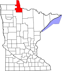 | |
| Townships | ||
| CDP | ||
| Unincorporated communities |
| |
| Indian reservations | ||
| Ghost towns | ||
| Footnotes | ‡This populated place also has portions in an adjacent county or counties | |
Coordinates: 48°46′06″N 94°57′19″W / 48.76833°N 94.95528°W