Williamsport, Maryland
| Town of Williamsport, Maryland | |
|---|---|
| Town | |
|
Conococheague Street in Williamsport in 2007 | |
 Location of Williamsport, Maryland | |
| Coordinates: 39°35′55″N 77°49′6″W / 39.59861°N 77.81833°WCoordinates: 39°35′55″N 77°49′6″W / 39.59861°N 77.81833°W | |
| Country | United States |
| State | Maryland |
| County | Washington |
| Government[1] | |
| • Mayor | James G. McCleaf II |
| • Assistant Mayor | Anthony T. Drury |
| Area[2] | |
| • Total | 1.04 sq mi (2.69 km2) |
| • Land | 1.04 sq mi (2.69 km2) |
| • Water | 0 sq mi (0 km2) |
| Elevation | 407 ft (124 m) |
| Population (2010)[3] | |
| • Total | 2,137 |
| • Estimate (2012[4]) | 2,138 |
| • Density | 2,054.8/sq mi (793.4/km2) |
| Time zone | Eastern (EST) (UTC-5) |
| • Summer (DST) | EDT (UTC-4) |
| ZIP code | 21795 |
| Area code(s) | 301 |
| FIPS code | 24-85100 |
| GNIS feature ID | 0591561 |
| Website | http://williamsportmd.gov/ |

Williamsport is a town in Washington County, Maryland, United States. It has a rich history and almost became the capital for the state of Maryland. The population was 1,868 at the 2000 census and 2,137 at the 2010 census.[5]
Geography
Williamsport is located at 39°35′55″N 77°49′6″W / 39.59861°N 77.81833°W (39.598496, −77.818464).[6]
According to the United States Census Bureau, the town has a total area of 1.04 square miles (2.69 km2), all of it land.[2]
Williamsport is located 7.69 miles driving distance SW of Hagerstown, Maryland[7] and 16.23 miles driving distance N of Martinsburg, West Virginia.[8]
Climate
The climate in this area is characterized by hot, humid summers and generally mild to cool winters. According to the Köppen Climate Classification system, Williamsport has a humid subtropical climate, abbreviated "Cfa" on climate maps.[9]
Demographics
| Historical population | |||
|---|---|---|---|
| Census | Pop. | %± | |
| 1850 | 1,091 | — | |
| 1860 | 1,016 | −6.9% | |
| 1870 | 1,283 | 26.3% | |
| 1880 | 1,503 | 17.1% | |
| 1890 | 1,277 | −15.0% | |
| 1900 | 1,472 | 15.3% | |
| 1910 | 1,571 | 6.7% | |
| 1920 | 1,615 | 2.8% | |
| 1930 | 1,775 | 9.9% | |
| 1940 | 1,772 | −0.2% | |
| 1950 | 1,890 | 6.7% | |
| 1960 | 1,853 | −2.0% | |
| 1970 | 2,270 | 22.5% | |
| 1980 | 2,153 | −5.2% | |
| 1990 | 2,103 | −2.3% | |
| 2000 | 1,868 | −11.2% | |
| 2010 | 2,137 | 14.4% | |
| Est. 2015 | 2,162 | [10] | 1.2% |
2010 census
As of the census[3] of 2010, there were 2,137 people, 960 households, and 543 families residing in the town. The population density was 2,054.8 inhabitants per square mile (793.4/km2). There were 1,080 housing units at an average density of 1,038.5 per square mile (401.0/km2). The racial makeup of the town was 95.6% White, 2.5% African American, 0.1% Native American, 0.3% Asian, 0.3% from other races, and 1.1% from two or more races. Hispanic or Latino of any race were 1.1% of the population.
There were 960 households of which 25.9% had children under the age of 18 living with them, 36.7% were married couples living together, 12.9% had a female householder with no husband present, 7.0% had a male householder with no wife present, and 43.4% were non-families. 38.5% of all households were made up of individuals and 19.8% had someone living alone who was 65 years of age or older. The average household size was 2.12 and the average family size was 2.73.
The median age in the town was 44.9 years. 19% of residents were under the age of 18; 7.8% were between the ages of 18 and 24; 23.3% were from 25 to 44; 26.4% were from 45 to 64; and 23.4% were 65 years of age or older. The gender makeup of the town was 46.0% male and 54.0% female.
2000 census
As of the census[12] of 2000, there were 1,868 people, 785 households, and 471 families residing in the town. The population density was 1,725.6 people per square mile (667.8/km²). There were 836 housing units at an average density of 772.3 per square mile (298.9/km²). The racial makeup of the town was 98.29% White, 0.80% African American, 0.05% Native American, 0.16% Asian, 0.27% from other races, and 0.43% from two or more races. Hispanic or Latino of any race were 0.27% of the population.
There were 785 households out of which 27.0% had children under the age of 18 living with them, 43.7% were married couples living together, 12.0% had a female householder with no husband present, and 40.0% were non-families. 35.7% of all households were made up of individuals and 17.6% had someone living alone who was 65 years of age or older. The average household size was 2.21 and the average family size was 2.84.
In the town the population was spread out with 20.0% under the age of 18, 7.2% from 18 to 24, 26.3% from 25 to 44, 22.8% from 45 to 64, and 23.7% who were 65 years of age or older. The median age was 43 years. For every 100 females there were 80.7 males. For every 100 females age 18 and over, there were 76.5 males.
The median income for a household in the town was $34,243, and the median income for a family was $41,115. Males had a median income of $30,833 versus $21,708 for females. The per capita income for the town was $16,179. About 7.4% of families and 8.5% of the population were below the poverty line, including 4.8% of those under age 18 and 14.8% of those age 65 or over.
Notable people
- Nick Adenhart, former MLB pitcher
- Dave Cole, former MLB pitcher
- Gina Marie Groh, United States District Court Judge
History
The town lies on one of the early Native American trails between New York and the Carolinas. In the mid-18th century, tens of thousands of European settlers and pioneer families with their wagons followed the same route on the Great Wagon Road from Pennsylvania to Virginia and points south and west. In 1744, a ferry was established at the present site of Williamsport to carry the traffic across the Potomac River. Today’s travelers make the crossing on Interstate 81 a mile downriver from the town.
The land of present-day Williamsport was previously owned by Otho Holland Williams, a Continental Army officer in the American Revolutionary War, and for whom the town is named.
Cedar Grove, Daniel Donnelly House, Elmwood, Rose Hill, Sprechers Mill House, Springfield Farm, Tammany, and the Williamsport Historic District are listed on the National Register of Historic Places.[13][14]
Economic growth
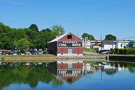
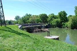
In 1834, boats using a portion of the newly built Chesapeake and Ohio Canal were able to reach Williamsport from Washington, D.C. The canal itself was extended to Williamsport in 1835.[15]:96 The canal became an important commercial route which connected the area with the lower Potomac River region and the Chesapeake Bay, and later with the Cumberland, Maryland region as the canal construction continued westward. Williamsport became a very popular waterfront town which benefited the economy. In 1873, the Western Maryland Railway extended its line from Hagerstown to Williamsport, in order to gain access to canal traffic. Coal from Cumberland area mines was one of the principal commodities transferred from canal barges to rail cars at Williamsport.[16]
Flooding
In 1863, during the Civil War, the overflowing flooding waters of the river prevented General Robert E. Lee's army, on its retreat from Gettysburg, from crossing and making it safely into Virginia for several days.[15]:94 A large flood in 1924 caused extensive damage to the canal, which was then permanently shut down.[17]
Recent developments
The town's historic core was added to the National Register of Historic Places as the Williamsport Historic District in 2001.[18]
The town in May 2010 secured Michael Sparks, a previous town consultant and writer of a revitalization feasibility study, as Director of Economic and Community Development to revitalize downtown and attract tourism.[19][20] Mr. Sparks outlined a revitalization initiative with the acronym of C.A.R.E.
- C-Connecting the various assets of the Town both physically and aesthetically.
- A-Align and inform the merchants with the needs and demographics of tourists.
- R-Rebuild through improving building conditions with Code Enforcement and Ordinance changes.
- E-Entertainment and how to create excitement to pull tourist activity into the town so that it can be built upon and capitalized on by a revitalized Town Center.[21]
Over a one-year experiment with having a full-time economic development employee[22] hundreds of thousands of grant dollars were secured for projects including handicap accessibility for town buildings,[23] reconstruction of sewage pump stations,[24] a possible bike-and-boat rental facility,[25] and the town was approved as a Heart of the Civil War Heritage Area Target Investment Zone.[26] Bike lanes,[27] bike racks[26] and directional signage were installed to better direct tourists and connect the town with the Chesapeake and Ohio Canal National Historical Park.[23] A new permit process was set up with the Washington County, Maryland permit office, building code enforcement[26] and heavy truck traffic were addressed.[28] Events were coordinated that emphasized revitalization and the downtown merchants.[29][30][31] Additionally local youth were honored for community involvement,[32] events were coordinated for town youth[33] and a Boys and Girls Club was created.[34] The changes increased business in Williamsport.[35][36] The town is part of a regional initiative known as the Canal Towns Partnership.[37]
FirstEnergy corporation closed the R. Paul Smith Power Station in Williamsport on September 1, 2012.[38]
Highways
References
- ↑ McCleaf re-elected Williamsport mayor, Heather Keels, March 3, 2009, The Herald-Mail
- 1 2 "US Gazetteer files 2010". United States Census Bureau. Retrieved 2013-01-25.
- 1 2 "American FactFinder". United States Census Bureau. Retrieved 2013-01-25.
- ↑ "Population Estimates". United States Census Bureau. Retrieved 2013-06-26.
- ↑ Table 4: Annual Estimates of the Resident Population for Incorporated Places in Maryland, Listed Alphabetically: April 1, 2000 to July 1, 2008, U.S. Census Bureau, 2008. Released July 1, 2009. Retrieved July 1, 2009.
- ↑ "US Gazetteer files: 2010, 2000, and 1990". United States Census Bureau. 2011-02-12. Retrieved 2011-04-23.
- ↑ Driving Directions from Williamsport, MD to Hagerstown, MD, Mapquest. Accessed February 22, 2009.
- ↑ Driving Directions from Williamsport, MD to Martinsburg, WV, Mapquest. Accessed February 22, 2009.
- ↑ Climate Summary for Williamsport, Maryland
- ↑ "Annual Estimates of the Resident Population for Incorporated Places: April 1, 2010 to July 1, 2015". Retrieved July 2, 2016.
- ↑ "Census of Population and Housing". Census.gov. Retrieved June 4, 2015.
- ↑ "American FactFinder". United States Census Bureau. Retrieved 2008-01-31.
- ↑ National Park Service (2010-07-09). "National Register Information System". National Register of Historic Places. National Park Service.
- ↑ "National Register of Historic Places Listings". Weekly List of Actions Taken on Properties: 12/26/12 through 12/28/12. National Park Service. 2013-01-04.
- 1 2 Chesapeake and Ohio Canal. Washington, D.C.: National Park Service. 1991. ISBN 0-912627-43-3. Handbook No. 142.
- ↑ Cook, Roger; Zimmermann, Karl (1992). The Western Maryland Railway: Fireballs and Black Diamonds (2nd ed.). Laurys Station, Pennsylvania: Garrigues House. pp. 33–34. ISBN 0-9620844-4-1.
- ↑ National Park Service. "Canal Operation". Chesapeake and Ohio Canal National Historic Park. Retrieved 2012-10-22.
- ↑ National Park Service (2008-04-15). "National Register Information System". National Register of Historic Places. National Park Service.
- ↑ Williamsport Budget, Andrew Schotz June 14, 2010.
- ↑ http://www.williamsportmd.gov/docs/minutes/minutes030110.pdf
- ↑ http://www.williamsportmd.gov/docs/minutes/minutes080910.pdf
- ↑ "$3.91 million budget proposed for Williamsport". herald-mail.com. June 5, 2011. Retrieved October 17, 2011.
- 1 2 "Williamsport briefs". herald-mail.com. March 15, 2011. Retrieved October 17, 2011.
- ↑ "Town Gets Grant to Help Update Sewer System". Your4State.com. March 10, 2011. Retrieved October 17, 2011.
- ↑ "Bike-and-boat rental facility in Williamsport tops list of federal grant requests". herald-mail.com. May 4, 2011. Retrieved October 17, 2011.
- 1 2 3 http://www.williamsportmd.gov/docs/minutes/minutes071210.pdf
- ↑ "Canal Trust". Canal Trust. June 15, 2010. Retrieved October 17, 2011.
- ↑ "Williamsport considers restricting truck weight". herald-mail.com. March 7, 2011. Retrieved October 17, 2011.
- ↑ "Williamsport Overtaken by Pirates". Your4State.com. September 19, 2010. Retrieved October 17, 2011.
- ↑ "Pirates Set to Take Over Williamsport". Your4State.com. September 17, 2010. Retrieved October 17, 2011.
- ↑ "Pirates plunder Williamsport – Herald-Mail". Articles.herald-mail.com. September 19, 2010. Retrieved October 17, 2011.
- ↑ "Williamsport students honored for International Youth Day – Herald-Mail". Articles.herald-mail.com. August 12, 2010. Retrieved October 17, 2011.
- ↑ "Williamsport gives youths Last Blast of summer – Herald-Mail". Articles.herald-mail.com. August 15, 2010. Retrieved October 17, 2011.
- ↑ http://www.bgcwc.com/Images/Images/williamsport%20gets%20a%20boys%20&%20girls%20club.pdf
- ↑ "Business owners: Williamsport's plan to attract tourists is working". herald-mail.com. February 15, 2011. Retrieved October 17, 2011.
- ↑ "Small Change Creates Big Boom in Business for Cafe Owner". Your4State.com. August 3, 2010. Retrieved October 17, 2011.
- ↑ "Williamsport, MD – Potomac Heritage Explorer". Potomacheritage.net. April 11, 2011. Retrieved October 17, 2011.
- ↑ Maryland Department of the Environment, Baltimore, MD (2013-04-05). "Notice of Proposed Action: 26.11.27 Emission Limitations for Power Plants." Maryland Register, Vol. 40, Issue 7. pp. 626-7.
External links
| Wikimedia Commons has media related to Williamsport, Maryland. |
- Welcome to Williamsport, Maryland
- The C&O Canal in Washington County - Western Maryland Regional Library
Municipalities and communities of Washington County, Maryland, United States | ||
|---|---|---|
| City | 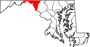 | |
| Towns | ||
| CDPs |
| |
| Other communities | ||