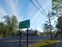
Williamsville, New York
| Williamsville, New York | |
|---|---|
| Village | |
 | |
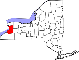
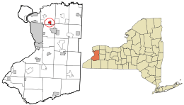 Location in Erie County and the state of New York | |
| Coordinates: 42°57′45″N 78°44′33″W / 42.96250°N 78.74250°W | |
| Country | United States |
| State | New York |
| County | Erie |
| Towns | Amherst, Cheektowaga |
| Government | |
| • Mayor | Brian J. Kulpa |
| Area | |
| • Total | 1.2 sq mi (3.2 km2) |
| • Land | 1.2 sq mi (3.2 km2) |
| • Water | 0.0 sq mi (0.0 km2) |
| Elevation | 676 ft (206 m) |
| Population (2010) | |
| • Total | 5,300 |
| • Density | 4,300/sq mi (1,700/km2) |
| Time zone | Eastern (EST) (UTC-5) |
| • Summer (DST) | EDT (UTC-4) |
| ZIP codes | 14221, 14231 |
| Area code(s) | 716 |
| FIPS code | 36-82084[1] |
| GNIS feature ID | 0971319[2] |
| Website |
www |
Williamsville is a village in Erie County, New York, in the United States. The population was 5,300 at the 2010 census. The village is named after Jonas Williams, an early settler. It is part of the Buffalo–Niagara Falls Metropolitan Statistical Area.
Williamsville is located mostly within the town of Amherst, but Creek Road and Creek Heights in the south part of the village (near the Wehrle Drive underpass of the New York State Thruway) are in the town of Cheektowaga. The village is in the northeastern quadrant of Erie County.
Williamsville is also a postal ZIP code: 14221 (14231 for post office boxes); however, that ZIP code contains large sections of the town outside of the village and also includes significant commercial areas within Clarence.
The Williamsville Central School District is a school system covering Williamsville, most of the eastern part of Amherst, and a small portion of the western end of Clarence.
History
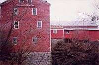
The community developed where the major road between Batavia and Buffalo crossed Ellicott Creek just above Glen Falls. The water power offered by the waterfall attracted millers. The first mill was built by Jonas Williams in 1811, giving the village its first name, "Williams Mills". It still stands today, next to Glen Park, and is known as the Williamsville Water Mill. Several other mills were built near Glen Falls during the 19th century. In 1841, a raceway was constructed to divert water from Ellicott Creek to the mills, creating an island known today as Island Park. A stagecoach stop, tavern, and inn was built along the main road near Ellicott Creek by Oziel Smith in 1832. Today it is known as the Eagle House. The close crossing of the main road and Ellicott Creek's Glen Falls was the initial attraction, around which Williamsville grew. The village was incorporated in 1850.
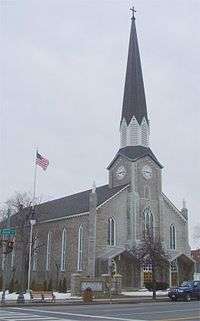
St. John Neumann served as founder and first pastor of SS Peter and Paul Roman Catholic Church from 1836 to 1840.
During the War of 1812, American troops were stationed in Williamsville in the area between Garrison Road and Ellicott Creek. American soldiers and British prisoners were treated in a field hospital and log barracks that lined Garrison Road. A small cemetery, located on Aero Drive between Wehrle and Youngs Road, was used to bury the men who did not survive. General Winfield Scott used the Evans House as his headquarters in the Spring of 1813 when his entire army of 5,000–6,000 men were stationed in Williamsville. In 1813, when the British burned Buffalo, people fled to the safety of Williamsville and nearby Harris Hill.
In 1850, the village of Williamsville was one of the 500+ incorporated villages by New York State
In 1983, Williamsville passed an Historic Preservation Code to conserve its old buildings.
Every summer in Williamsville, Old Home Days[3] is held in Island Park, located directly on Main Street in the village. The Carnival begins with a parade on the opening Tuesday, and for four days, thousands of people ride the rides, enjoy the food, and see the people Williamsville has to offer. The festival is in remembrance of several women who in the mid-19th century would come to the park once a summer to drink tea and catch up on the years past.
In 2010, government downsizing activist Kevin Gaughan campaigned to dissolve the village government. After a highly contentious campaign, a dissolution referendum was held on August 17, 2010, where voters rejected dissolution by a 5–1 margin.[4]
Landmarks

Williamsville has several parks. Glen Park, 10 acres (4.0 ha) (the site of an amusement park in the 1940s and 1950s), offers views of Ellicott Creek as it falls over the Onondaga Escarpment, forming the 27-foot-high (8.2 m) Glen Falls; Island Park has a large pavilion and is the site of Old Home Days and the Taste of Williamsville events during the summer.
SS Peter and Paul Roman Catholic Church is located on Main Street.
Williamsville boasts 11 sites that have been designated as historical sites.
The following are listed on the National Register of Historic Places: Former Reformed Mennonite Church, St. Mary of the Angels Motherhouse Complex, Williamsville Junior and Senior High School, Williamsville Christian Church, Village Meeting House, and Williamsville Water Mill Complex.[5]
Recreation
As stated above the big festival in Williamsville is Old Home Days and there also is the taste of Williamsville. During the summer there is also a musical festival on Main Street where local bands play on street corners during various days.
Other recreational facilities in town include a rollerskating rink and the 1.5-mile (2.4 km) Lehigh Valley Railroad Path.
Other events, places, and recreation nearby Williamsville, Ny. include: Duffs and Anchor Bar's famous chicken wings, Wing-fest, Darien Lake, The Buffalo Zoo, Albright Knox Art Gallery, The City of Buffalo, and Niagara Falls.
Geography
According to the United States Census Bureau, the village has a total area of 1.2 square miles (3.1 km2), all land.
Ellicott Creek flows through the village from south to north. The Onondaga Escarpment runs through the village east-west. Glen Falls marks the place where Ellicott Creek falls over the escarpment. An early name for Ellicott Creek was "Eleven Mile Creek".
Main Street is part of the east–west New York State Route 5 (NY 5). Joseph Ellicott had the "Great Iroquois Trail", an ancient path from the Hudson River to Lake Erie, improved. It was known as the "Buffalo Road" and, later, "Main Street". North Union Road, part of NY 277, is a major north-south road through the west end of the village. Transit Road, surveyed by Joseph Ellicott, was named for an important surveying instrument. Transit Road marks the boundary between townships (Amherst and Clarence, Cheektowaga and Lancaster, inter alia. Joseph Ellicott's surveys of western New York divided the Holland Purchase land into a grid of more or less square of townships with boundaries aligned north-south and east-west, a system related to the Public Land Survey System (PLSS) used in most of the rest of post-colonial America. In western New York, strict accordance to the PLSS was not required or followed, since the land was not federally owned, but had passed directly from the Seneca Indians to land speculators such as the Holland Land Company.
The New York State Thruway (Interstate 90 or I-90) passes through the south part of the village and connects to I-290. A Thruway toll plaza located near the village has been a matter of controversy for years and recent proposals suggest it may be moved farther east.
Demographics
| Historical population | |||
|---|---|---|---|
| Census | Pop. | %± | |
| 1870 | 912 | — | |
| 1880 | 880 | −3.5% | |
| 1900 | 905 | — | |
| 1910 | 1,105 | 22.1% | |
| 1920 | 1,667 | 50.9% | |
| 1930 | 3,119 | 87.1% | |
| 1940 | 3,614 | 15.9% | |
| 1950 | 4,649 | 28.6% | |
| 1960 | 6,316 | 35.9% | |
| 1970 | 6,878 | 8.9% | |
| 1980 | 6,017 | −12.5% | |
| 1990 | 5,583 | −7.2% | |
| 2000 | 5,573 | −0.2% | |
| 2010 | 5,300 | −4.9% | |
| Est. 2015 | 5,254 | [6] | −0.9% |
As of the census[1] of 2010, there were 5,300 people, 2,534 households, 1,252 families residing in the village, 523 With own children under 18 years. The population density was 4,206.3 people per square mile (1,721.4/km²). There were 2,695 housing units at an average density of 2,107.0 per square mile (815.4/km²). The racial makeup of the village was 91.6% White, 4.2% Asian, 2.2% African American, 0.11% Native American, 0.6% from other races, and 1.3% from two or more races. Hispanic or Latino of any race were 1.7% of the population.
There were 2,534 households out of which 14.6% had children under the age of 18 living with them, 36.7% were married couples living together, 9.9% had a female householder with no husband present, and 50.6% were non-families. 44.4% of all households were made up of individuals and 20.5% had someone living alone who was 65 years of age or older. The average household size was 2.01 and the average family size was 2.87.
In the village, the population was spread out with 19.6% under the age of 19, 5.8% from 20 to 24, 26.6% from 25 to 44, 28.2% from 45 to 64, and 23.4% who were 65 years of age or older. The median age range was 45–49 years. The population is 43.7% male and 56.3% female.
According to the 2000 census, The median income for a household in the village was $47,557, and the median income for a family was $65,300. Males had a median income of $43,500 versus $32,172 for females. The per capita income for the village was $27,177. About 2.5% of families and 4.5% of the population were below the poverty line, including 2.7% of those under age 18 and 4.7% of those age 65 or over.
In 2007 it was found that the violent crimes per 1,000 residents were measured at 1.13, where as the national median was 4.0, property crimes (per 1000) were at 16.98, the national average was 29.4, and crimes per square mile were at 13, the national average was at 39.3.
School districts
Children of school age may attend public schools within the Williamsville Central School District, which is composed of six elementary schools, Country Parkway Elementary, Dodge Elementary, Forest Elementary, Heim Elementary, Maple East and Maple West Elementary (grades K–4); four middle schools including Casey Middle, Heim Middle, Mill Middle, Transit Middle (5–8); and three high schools, Williamsville East, North and South (9–12).
The Williamsville Central School District is one of the better public school systems in the nation. Students in this school system when compared to the nation in 2007 tested better than 81% of students in the United States, and 77% better than students in the United States in Reading.
Williamsville was ranked top district out of 97 public school districts in western NY, 2012.[8] Williamsville East, South, North High schools awarded gold, silver medals in 2012 U.S. News Best High Schools, ranking 57th, 86th, 88th out of 1165 in the state respectively. These 3 high schools rank among the top 2-3% out of 21,776 public high schools nationally; 2012.[9]
The private schools of Williamsville include Saints Peter and Paul and Christian Central Academy. Other private schools nearby include St. Gregory the Great, St. Mary's of Swormville, Nichols, the Buffalo Academy of the Sacred Heart, and Buffalo Seminary.
Notable people
- Marty Angelo, minister and author
- Jacob Artist, actor on FOX's Glee
- Justin Bailey, minor league hockey player
- Alfred F. Beiter, former US congressman
- Charles F. Bishop, former mayor of Buffalo, New York
- W. H. Clatworthy, University at Buffalo professor, World War II veteran
- Thomas Dao (1921–2009), physician who developed breast cancer treatment alternatives[10]
- Jim Dombrowski, former pro football player
- Ryan Dunn, actor
- Benjamin Ellicott, former US congressman
- Jeff Farkas, former NHL player
- Paul Fix II, racecar driver
- Shelby Fix, media personality
- Charles V. Fornes, former US congressman
- Glenn Gronkowski, American football player
- Rob Gronkowski, American football player for the New England Patriots
- Robert Guthrie, developed the bacterial inhibition assay used to screen infants for phenylketonuria at birth
- Robert Kinkel, Trans-Siberian Orchestra composer and keyboardist
- Rob Lalonde, professional ice hockey player
- David Leggio, minor league hockey player
- Dan Macaulay, singer, songwriter
- Todd Marchant, retired professional ice hockey player
- Kendell McFayden, professional soccer player
- Robert Moog (1934–2005), inventor of the Moog synthesizer and founder of Moog Music
- John Neumann (1811–1860), canonized Roman Catholic priest and bishop who was the founder and first pastor of SS Peter and Paul Catholic Church in Williamsville
- Lyman C. Pettit, founder and first president of the Pentecostal Collegiate Institute (now Eastern Nazarene College)
- Mary Lou Rath, former New York state senator
- Mario J. Rossetti, New York Supreme Court justice
- Alex Sahlen, professional soccer player
- Peter Scamurra, retired NHL player
- John B. Sheffer II, former village mayor, New York assemblyman and state senator
- Faith Whittlesey, former White House senior staff member
References
- 1 2 "American FactFinder". United States Census Bureau. Retrieved 2008-01-31.
- ↑ "US Board on Geographic Names". United States Geological Survey. 2007-10-25. Retrieved 2008-01-31.
- ↑ Welcome to OldHomeDays.org!
- ↑ http://www.publicbroadcasting.net/wbfo/news.newsmain/article/1/0/1689487/WBFO.News/Village.dissolution.rejected.in.Williamsville.and.Sloan
- ↑ National Park Service (2010-07-09). "National Register Information System". National Register of Historic Places. National Park Service.
- ↑ "Annual Estimates of the Resident Population for Incorporated Places: April 1, 2010 to July 1, 2015". Retrieved July 2, 2016.
- ↑ "Census of Population and Housing". Census.gov. Retrieved June 4, 2015.
- ↑ Thomas, Scott. "2012 School district rankings for western new york.". Retrieved 2 January 2013.
- ↑ "US News Best High Schools, 2012.". Retrieved 2 January 2013.
- ↑ Hevesi, Dennis. "Dr. Thomas Dao, Expert on Treatment of Breast Cancer, Dies at 88", The New York Times, July 25, 2009. Accessed July 26, 2009.
- http://www.neighborhoodscout.com/ny/williamsville/crime/
- http://www.wivb.com/dpp/news/local/WNY_School_district_rankings_20090604
- http://quickfacts.census.gov/qfd/states/36/3682084.html
- http://factfinder2.census.gov/faces/tableservices/jsf/pages/productview.xhtml?pid=DEC_10_DP_DPDP1&prodType=table
- http://village.williamsville.ny.us/history.html
External links
- Village of Williamsville official website
- A History of the Town of Amherst, New York — Sue Miller Young, 1965
Coordinates: 42°57′49″N 78°44′24″W / 42.96365°N 78.73994°W