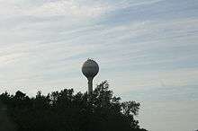
Wittenberg, Wisconsin
| Wittenberg, Wisconsin | |
|---|---|
| Village | |
|
Wittenberg | |
 Location of Wittenberg, Wisconsin | |
| Coordinates: 44°49′24″N 89°9′25″W / 44.82333°N 89.15694°WCoordinates: 44°49′24″N 89°9′25″W / 44.82333°N 89.15694°W | |
| Country | United States |
| State | Wisconsin |
| County | Shawano |
| Area[1] | |
| • Total | 1.79 sq mi (4.64 km2) |
| • Land | 1.79 sq mi (4.64 km2) |
| • Water | 0 sq mi (0 km2) |
| Elevation[2] | 873 ft (266 m) |
| Population (2010)[3] | |
| • Total | 1,081 |
| • Estimate (2012[4]) | 1,069 |
| • Density | 603.9/sq mi (233.2/km2) |
| Time zone | Central (CST) (UTC-6) |
| • Summer (DST) | CDT (UTC-5) |
| ZIP code | 54499-9033 |
| Area code(s) | 715 & 534 |
| FIPS code | 55-88350[5] |
| GNIS feature ID | 1584467[2] |
| Website | http://www.villageofwittenberg.com |
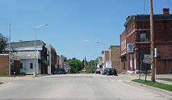
Wittenberg is a village in Shawano County, Wisconsin, Wisconsin, United States. The population was 1,081 at the 2010 census. The village is located within the Town of Wittenberg.
History
A post office called Wittenberg has been in operation since 1880.[6] The village was named after Wittenberg, in Germany.[7]
Geography
Wittenberg is located at 44°49′25″N 89°10′2″W / 44.82361°N 89.16722°W (44.823795, -89.167328).[8]
According to the United States Census Bureau, the village has a total area of 1.79 square miles (4.64 km2), all of it land.[1]
Demographics
| Historical population | |||
|---|---|---|---|
| Census | Pop. | %± | |
| 1890 | 726 | — | |
| 1900 | 798 | 9.9% | |
| 1910 | 1,090 | 36.6% | |
| 1920 | 854 | −21.7% | |
| 1930 | 863 | 1.1% | |
| 1940 | 900 | 4.3% | |
| 1950 | 874 | −2.9% | |
| 1960 | 892 | 2.1% | |
| 1970 | 895 | 0.3% | |
| 1980 | 997 | 11.4% | |
| 1990 | 1,145 | 14.8% | |
| 2000 | 1,177 | 2.8% | |
| 2010 | 1,081 | −8.2% | |
| Est. 2015 | 1,022 | [9] | −5.5% |
2010 census
As of the census[3] of 2010, there were 1,081 people, 427 households, and 231 families residing in the village. The population density was 603.9 inhabitants per square mile (233.2/km2). There were 495 housing units at an average density of 276.5 per square mile (106.8/km2). The racial makeup of the village was 89.3% White, 3.8% Native American, 0.2% Asian, 5.1% from other races, and 1.7% from two or more races. Hispanic or Latino of any race were 7.1% of the population.
There were 427 households of which 29.0% had children under the age of 18 living with them, 35.6% were married couples living together, 13.3% had a female householder with no husband present, 5.2% had a male householder with no wife present, and 45.9% were non-families. 40.5% of all households were made up of individuals and 18.5% had someone living alone who was 65 years of age or older. The average household size was 2.19 and the average family size was 2.94.
The median age in the village was 42.2 years. 22.7% of residents were under the age of 18; 8% were between the ages of 18 and 24; 22.6% were from 25 to 44; 21% were from 45 to 64; and 25.6% were 65 years of age or older. The gender makeup of the village was 46.6% male and 53.4% female.
2000 census
As of the census[5] of 2000, there were 1,177 people, 436 households, and 272 families residing in the village. The population density was 718.2 people per square mile (277.1/km²). There were 471 housing units at an average density of 287.4 per square mile (110.9/km²). The racial makeup of the village was 96.52% White, 0.17% Black or African American, 2.21% Native American, 0.08% Asian, and 1.02% from two or more races. 0.25% of the population were Hispanic or Latino of any race.
There were 436 households out of which 32.3% had children under the age of 18 living with them, 47.5% were married couples living together, 11.0% had a female householder with no husband present, and 37.6% were non-families. 33.3% of all households were made up of individuals and 17.9% had someone living alone who was 65 years of age or older. The average household size was 2.37 and the average family size was 3.02.
In the village the population was spread out with 24.8% under the age of 18, 6.5% from 18 to 24, 24.7% from 25 to 44, 15.3% from 45 to 64, and 28.7% who were 65 years of age or older. The median age was 40 years. For every 100 females there were 87.7 males. For every 100 females age 18 and over, there were 78.8 males.
The median income for a household in the village was $29,926, and the median income for a family was $40,074. Males had a median income of $28,571 versus $21,202 for females. The per capita income for the village was $17,695. About 9.2% of families and 12.9% of the population were below the poverty line, including 14.4% of those under age 18 and 10.4% of those age 65 or over.
Economy
Notable people
- John Englund, Wisconsin State Senator and newspaper editor, lived in Wittenberg.[11]
- Helmer Swenholt, United States Army officer, was born in Wittenberg.[12]
- Jonas Swenholt, Wisconsin State Assemblyman and businessman, lived in Wittenberg.[13]
References
- 1 2 "US Gazetteer files 2010". United States Census Bureau. Retrieved 2012-11-18.
- 1 2 "US Board on Geographic Names". United States Geological Survey. 2007-10-25. Retrieved 2008-01-31.
- 1 2 "American FactFinder". United States Census Bureau. Retrieved 2012-11-18.
- ↑ "Population Estimates". United States Census Bureau. Retrieved 2013-06-24.
- 1 2 "American FactFinder". United States Census Bureau. Retrieved 2008-01-31.
- ↑ "Shawano County". Jim Forte Postal History. Retrieved 1 April 2015.
- ↑ Chicago and North Western Railway Company (1908). A History of the Origin of the Place Names Connected with the Chicago & North Western and Chicago, St. Paul, Minneapolis & Omaha Railways. p. 140.
- ↑ "US Gazetteer files: 2010, 2000, and 1990". United States Census Bureau. 2011-02-12. Retrieved 2011-04-23.
- ↑ "Annual Estimates of the Resident Population for Incorporated Places: April 1, 2010 to July 1, 2015". Retrieved July 2, 2016.
- ↑ "Census of Population and Housing". Census.gov. Retrieved June 4, 2015.
- ↑ 'Wisconsin Blue Book 1927,' Biographical Sketch of John Englund, pg. 679-680
- ↑ 'History of Dane County: Biographical and Genealogical,' volume 1, Elisha Williams Keyes' Western Historical Association: 1906, Hon. Jonas Swenholt, pg. 870-871
- ↑ 'Wisconsin Blue Book 1905,' Biographical Sketch of Joan Swenholt, pg. 1117
External links
- Wittenberg official website
- Wittenberg Chamber of Commerce
- Wittenberg-Birnamwood School District
- Wausau Daily Record-Herald. "Wittenberg pioneer recalls early days when railroad came"
- Fire insurance maps: 1894 1901 1909 1919
Municipalities and communities of Shawano County, Wisconsin, United States | ||
|---|---|---|
| Cities | 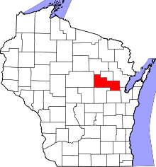 | |
| Villages | ||
| Towns | ||
| CDPs | ||
| Unincorporated communities | ||
| Indian reservations | ||
| Footnotes | ‡This populated place also has portions in an adjacent county or counties | |