Yongshun County
For the Beijing suburb, see Yongshun, Beijing.
| Yongshun County 永顺县 | |
|---|---|
| County | |
|
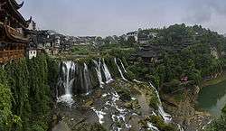
Panorama of Furong, a Tujia ancient town in Yongshun County | |
 Yongshun Location in Hunan | |
| Coordinates: 29°00′04″N 109°51′04″E / 29.001°N 109.851°ECoordinates: 29°00′04″N 109°51′04″E / 29.001°N 109.851°E[1] | |
| Country | People's Republic of China |
| Province | Hunan |
| Autonomous prefecture | Xiangxi |
| Area[2] | |
| • Total | 3,809.69 km2 (1,470.93 sq mi) |
| Elevation | 256 m (840 ft) |
| Population (2010)[3] | |
| • Total | 428,373 |
| • Density | 110/km2 (290/sq mi) |
| Time zone | China Standard (UTC+8) |
| Postal code | 4167XX |
Yongshun County (simplified Chinese: 永顺县; traditional Chinese: 永順縣; pinyin: Yǒngshùn Xiàn) is under the administration of Xiangxi Tujia and Miao Autonomous Prefecture, Hunan province, China. It borders the prefecture-level cities of Zhangjiajie to the northeast and Huaihua to the southeast.
Settlements
Settlements in Yongshun county include:
References
- www.xzqh.org (Chinese)
- ↑ Google (2014-07-02). "Yongshun" (Map). Google Maps. Google. Retrieved 2014-07-02.
- ↑ Xiangxi Tujia and Miao Autonomous Prefecture Land Use Plan (2006–20)/《湘西土家族苗族自治州土地利用总体规划(2006-2020年)》.(Chinese) Accessed 8 July 2014.
- ↑ 湘西自治州2010年第六次全国人口普查主要数据公报 (in Chinese). Xiangxi Prefecture People's Government. Retrieved 9 July 2014.
External links
This article is issued from Wikipedia - version of the 10/28/2016. The text is available under the Creative Commons Attribution/Share Alike but additional terms may apply for the media files.