Zuni Pueblo, New Mexico
| Zuni Pueblo, New Mexico | |
|---|---|
| CDP | |
|
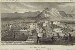
Zuni Pueblo, 1850 illustration | |
 Location of Zuni Pueblo, New Mexico | |
 Zuni Pueblo, New Mexico Location in the United States | |
| Coordinates: 35°4′10″N 108°50′48″W / 35.06944°N 108.84667°WCoordinates: 35°4′10″N 108°50′48″W / 35.06944°N 108.84667°W | |
| Country | United States |
| State | New Mexico |
| County | McKinley |
| Area | |
| • Total | 8.8 sq mi (22.9 km2) |
| • Land | 8.8 sq mi (22.9 km2) |
| • Water | 0.0 sq mi (0.0 km2) |
| Elevation | 6,293 ft (1,918 m) |
| Population (2000) | |
| • Total | 6,367 |
| • Density | 720.0/sq mi (278.0/km2) |
| Time zone | Mountain (MST) (UTC-7) |
| • Summer (DST) | MDT (UTC-6) |
| ZIP code | 87327 |
| Area code(s) | 505 |
| FIPS code | 35-86595 |
| GNIS feature ID | 1867391 |
Zuni Pueblo (Zuni: Shiwinna, also Zuñi Pueblo and Pueblo de Zuñi) is a census-designated place (CDP) in McKinley County, New Mexico, United States. The population was 6,302 as of the 2010 Census.[1] It is inhabited largely by members of the Zuni people.
The first contact with Europeans occurred in 1539 in the ancient village of Hawikku when Esteban, an Arab/Berber of Moroccan origin, entered Zuni territory seeking the fabled "Seven Cities of Cibola."[2]
It is on the Trails of the Ancients Byway, one of the designated New Mexico Scenic Byways.[3]
Geography
Zuni Pueblo is located at 35°4′10″N 108°50′48″W / 35.06944°N 108.84667°W (35.069327, -108.846716).[4]
According to the United States Census Bureau, the CDP has a total area of 8.8 square miles (23 km2), all land.
Demographics
As of the census[5] of 2000, there were 6,367 people, 1,488 households, and 1,334 families residing in the CDP. The population density was 720.0 people per square mile (278.1/km²). There were 1,622 housing units at an average density of 183.4 per square mile (70.8/km²). The racial makeup of the CDP was 97.03% Native American, 2.12% White, 2.01% Hispanic or Latino, 0.03% African American, 0.03% Asian, 0.30% from other races, and 0.49% from two or more races.
There were 1,488 households out of which 42.1% had children under the age of 18 living with them, 51.1% were married couples living together, 31.7% had a female householder with no husband present, and 10.3% were non-families. 9.0% of all households were made up of individuals and 1.5% had someone living alone who was 65 years of age or older. The average household size was 4.26 and the average family size was 4.54.
In the CDP the population was spread out with 34.7% under the age of 18, 9.8% from 18 to 24, 32.3% from 25 to 44, 16.8% from 45 to 64, and 6.3% who were 65 years of age or older. The median age was 29 years. For every 100 females there were 92.7 males. For every 100 females age 18 and over, there were 89.2 males.
The median income for a household in the CDP was $22,559, and the median income for a family was $22,067. Males had a median income of $18,345 versus $18,635 for females. The per capita income for the CDP was $6,908. About 40.0% of families and 43.0% of the population were below the poverty line, including 49.7% of those under age 18 and 41.7% of those age 65 or over.
Transport
The area is served by the nearby Black Rock Airport.
Education
Zuni Public Schools operates schools serving the community.
The Zuni Public Library is located at 27 East Chavez Circle. In 1974 Dr. Lotsee Patterson and Ben Wakashige started a project to help tribal areas establish libraries. The Zuni library opened in 1975.[6]
See also
 First terrace of Zuni in 1879
 Zuni Pueblo, 1873. Timothy H. O'Sullivan, photographer
References
- ↑ "Population estimates, July 1, 2015, (V2015)". www.census.gov. Retrieved 2016-05-05.
- ↑ Ferguson, T.J. (1985). A Zuni Atlas. Norman, OK: University of Oklahoma Press.
- ↑ Trail of the Ancients. New Mexico Tourism Department. Retrieved August 14, 2014.
- ↑ "US Gazetteer files: 2010, 2000, and 1990". United States Census Bureau. 2011-02-12. Retrieved 2011-04-23.
- ↑ "American FactFinder". United States Census Bureau. Archived from the original on September 11, 2013. Retrieved 2008-01-31.
- ↑ "Zuni Public Library." Pueblo of Zuni. Retrieved on April 22, 2009.
External links
- Pueblo of the Zuni - official site
- Zuni Department of Tourism
- Historic photos of Zuni Pueblo, Timothy H. O'Sullivan, photographer
- American Southwest, a National Park Service Discover Our Shared Heritage Travel Itinerary
| Reservations | |
|---|---|
| Pueblos | |
Municipalities and communities of McKinley County, New Mexico, United States | ||
|---|---|---|
| City |  | |
| CDPs | ||
| Unincorporated communities | ||
| Indian reservation |
| |
| Footnotes | ‡This populated place also has portions in an adjacent county or counties | |